Rust Family Foundation: Archaeology Grants Program
Archaeological Excavations at Gird-i Rostam (Kurdistan Region of Iraq)
Principal Investigators:
D.T. Potts, Professor of Ancient Near Eastern Archaeology and History
Institute for the Study of the Ancient World, New York University
Karen Radner, Alexander von Humboldt Professor for the Ancient History of the Near and Middle East
Ludwig-Maximilians-University Munich
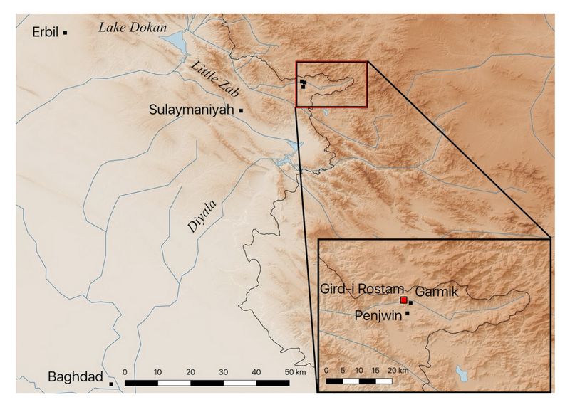
Located close to the Shalr River near Penjwin in the Kurdistan Region of Iraq, Gird-i Rostam is the largest site in the area of the far eastern part of the Sulaimaniyah Governate (fig.1). Preliminary exc
 avations in Gird-i
Rostam show
that this specific area of eastern Kurdistan, like the
better known areas to the north and west, affords an opportunity to
explore both local, indigenous development and the external relations
of an area at the crossroads of the Mesopotamian and Zagrosian worlds.
avations in Gird-i
Rostam show
that this specific area of eastern Kurdistan, like the
better known areas to the north and west, affords an opportunity to
explore both local, indigenous development and the external relations
of an area at the crossroads of the Mesopotamian and Zagrosian worlds.Fig.1: Map showing location of Gird-i-Rostam in the Sulaimaniyah region.
Previous work at the site::
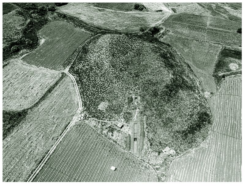
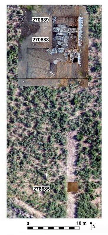
In 1959, the Directorate of Antiquities in Baghdad visited Gird-i Rostam and, on the basis of surface finds, attributed occupation at the site to the Uruk and Old Babylonian or Isin-Larsa periods. In 2016, Gird-i Rostam was first investigated by the Directorate of Antiquities in Sulaimaniyah. The next year (2017) the site was mapped by drone, and a 2 x 60 m step-trench was laid out from the bottom of the central mound (fig.2).
 In 2018, an initial season of excavations at Gird-i Rostam demonstrated the potential of the site. A large quantity of diagnostic pottery was recovered
from two relatively small soundings, suggesting that the site was
occupied in the Sasanian and Late Chalcolithic periods (figs.2,4). A C14 date in
the late third millennium BC implies Bronze Age occupation, and a short cuneiform inscription (described below) shows Neo-Assyrian ties.
In 2018, an initial season of excavations at Gird-i Rostam demonstrated the potential of the site. A large quantity of diagnostic pottery was recovered
from two relatively small soundings, suggesting that the site was
occupied in the Sasanian and Late Chalcolithic periods (figs.2,4). A C14 date in
the late third millennium BC implies Bronze Age occupation, and a short cuneiform inscription (described below) shows Neo-Assyrian ties.Fig.2: Drone photo of Gird-i Rostam showing the trenches opened in 2018 (A. Squitieri).
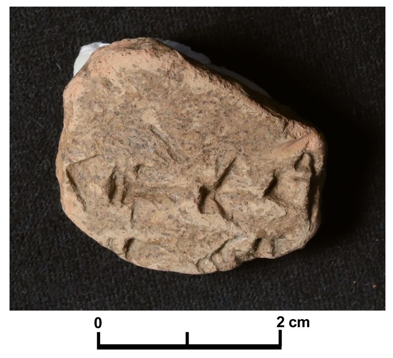
In 2018 a small sherd, originally part of a ceramic bowl, was discovered which turned out to have several cuneiform signs, belonging to two lines, impressed into its surface (fig.3). The text of which this forms a small part was written in clear, Neo-Assyrian signs (Radner 2021). Part of the term for a ‘wine-drinking bowl’ is clear in the first l
 ine, as is the name
of the weather god Adad (dIM) in the second line. Other Assyrian
drinking bowls, inscribed with short dedicatory texts are known, but
rather than a curse or a votive text mentioning Adad, it is more likely
that the divine name, here, is part of a longer placename. As it
happens, a ‘Fort Adad-remanni’ is known from Assyrian accounts of
campaigns against their eastern neighbors, the Manneans, in precisely
the region of Gird-i Rostam, raising the possibility that Fort
Adad-remanni may have stood on the site or even been the name of the
community itself.
ine, as is the name
of the weather god Adad (dIM) in the second line. Other Assyrian
drinking bowls, inscribed with short dedicatory texts are known, but
rather than a curse or a votive text mentioning Adad, it is more likely
that the divine name, here, is part of a longer placename. As it
happens, a ‘Fort Adad-remanni’ is known from Assyrian accounts of
campaigns against their eastern neighbors, the Manneans, in precisely
the region of Gird-i Rostam, raising the possibility that Fort
Adad-remanni may have stood on the site or even been the name of the
community itself.Fig.3: Fragmentary cuneiform inscription on the pottery sherd GiR 278688.10.5
photo: Karen Radner)
Current project (RFF-2019-88)
From 2-30 July 2019 the Joint Kurdish-German-American team from the Directorate of Antiquities in Sulaymaniyah, the Ludwig-Maximilians-University in Munich (LMU), and New York University conducted a second season of excavations at Gird-i Rostam. Excavations were concentrated in two areas which are described separately below. The discovery of a double wall with gateways, dated ceramically to the Iron Age, as well as an impressive Sasanian structure above it, increased the site's interest as a multi-component location.
Goals of the 2019 project:
1. Reaching virgin soil and determining whether the site was occupied during the Neolithic and Early and Middle Chalcolithic.
2. The refinement of the chronology of the Late Chalcolithic in northern Mesopotamia. The imprecise nature of the existing chronology shows dates for LC1-2 deposits between about 4800 BC and 3800 BC.
Fig.4: Late Chacolithic installations above virgin soil in the 2018 trench.
3. Defining the Assyrian impact on eastern Kurdistan — Despite a wealth of epigraphic evidence (principally the annals of the Neo-Assyrian kings and a few random finds like the texts from Qalat-i Dinka) — the archaeological signature of that impact is poorly known.
4. Improved focus on Gird-i Rostam and the Nestorian ecclesiastical province of Beth Garmai —The latest strata at Gird-i Rostam yielded several die-stamped sherds (fig.10 C,D) showing Christian crosses with close parallels in northern Iraq (e.g. Nineveh, Tell Sitak, Khirbet Deir Situn).
Methodology: Excavation
Square 278685
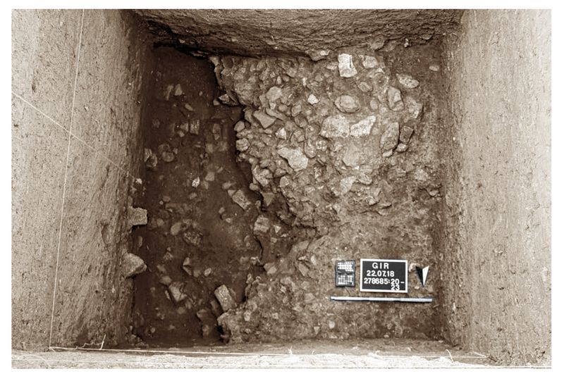
The aim of the second season of excavations in this square was to reach virgin soil and thereby complete the occupational sequence of Gird-i Rostam in the southernmost trench of the 2018 season (figs.4,5). Excavations reached virgin soil 2 m below the elevation of the nearby cultivated plain, and the oldest occupational phases of the site was documented as Late Chalcolithic (LC) 1-2, judging by the pottery recovered and a single radiocarbon date of 4446 – 4336 cal BC).
West of the wall-like stone installations at the highest elevation a deposit (Locus:278685:027 and Locus:278685:029) of clayey soil with fewer sherds and pebbles and some gravel marks the transition from virgin soil to the first LC settlement phase. At the bottom, on the east side, were stones and sherds (L.26 and L.31), representing the pebble floor (L.23) excavated in 2018. This may have functioned as a basin to hold water or to drain water to this point. This is the oldest LC installation excavated at Gird-i Rostam.
Fig.5: Excavation units in 2019.
Squares 278688 and 278689: Iron Age constructions
Excavations on the southern slope of Gird-i Rostam commenced on the 6th of July in
squares 278689 (5 x 8 m) and 278688 (10 x 10 m). However, most of the work this
season focused on the southern edge of square 278689 (2 x 5 m) and in the northeastern and southwestern parts of square 278688 (figs.4&6).
In the middle of the space 3, we found two rows of stone which might be the remains of an older drystone wall belonging to an earlier architectural level (L.37). These might bond at right angles with a north-south oriented wall running underneath both.
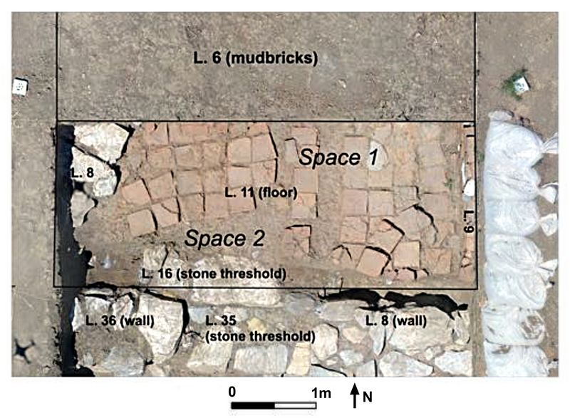
The oldest occupation investigated yielded a stone threshold (L.16 and L.35), which perhaps was part of an entrance to access the upper part of the settlement (fig.6). This entrance was bordered on both sides by two large, drystone stone walls (L.36 and L8), each about 1 m thick, oriented E-W (fig.6). The area to the north of the wall L.36 is part of an area (Space 2) located beneath the dark-brown fill L.14..
Fig.6: Plan view of Spaces 1 and 2 in Square 278689.
The stone entrance/threshold stepped down (3 steps) to another “space 3” at least 2.5 m wide (fig.7). It is delimited to the north by both drystone walls L.36 and L.8, with only two courses of stones preserved, and to the south by L.40 and L.48 and the threshold (L,41).
The space is paved with large slabs of local marble in irregular shapes and dimensions
(L.47 and L.12, 48, 49, 50, 51, 52) and with a beaten floor. Some stones are missing and no direct connections have been recovered between the floor and the northern walls (L.8 and L.036). The deposit L.32 above the floor yielded some clearly diagnostic Iron Age pottery types (burnished carinated bowls) and a large, broken ceramic tray, and a pot set between some dressed stones next to the southern stone entrance threshold. Some charcoal was found in this deposit, several samples of which were taken for radiocarbon dating.
On the last day of excavation, we found underneath an incurved rim bowl set on three dressed stones (L.55) above a door socket (L.54) belonging to the threshold L.041.
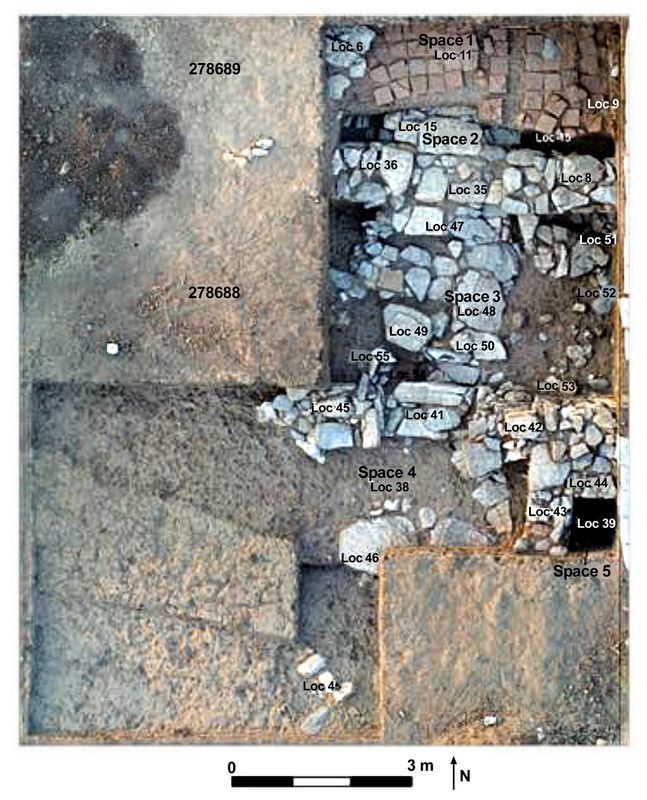
Square 278688: Space 4
Space 4, directly south of Space 3 (fig.7), is bounded on the north by the E-W running wall L.40 / L.42 with its stepped threshold L.41. To the east the N-S running wall L.43 borders this space. The edges of Space 4 to the south and east were not excavated.
Fig.7: Overhead view of Squares 278689 and 278688, showing spaces 1-5.
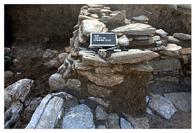
The northern wall separates the Space 4 from Space 3. Space 3 is accessible from Space 4 via the stepped threshold L.41. Three steps about 0.85 m wide lead upwards into Space 3, scaling a height difference of about 0.4 m. The door panels were built precisely with the flat façades of the stones on each side. The western part of the wall (L.40) is preserved up to 4 courses in height, while the eastern part (L.42) is preserved up to 7 courses (about 1.1 m) (fig.8). Their width is similar (0.80-0.85 m). Both parts of the wall lean towards the south, particularly the eastern part of the wall. Post-depositional processes caused this after Space 4 was already covered .
 Further east, wall L.43 is
perpendicular to the wall L.42 and preserved up to 7 courses. Both form the northeastern corner of Space 4. Inside Space 4 several stone slabs mark the floor-level (L.38) consisting of these stones and a beaten mud-floor. This mud-floor abuts the western wall as well as the northern wall except in the entrance, where the floor does not abut the lowest step. Further south, the westernmost slab (L.46) is both the floor-level and a step to a lower level, forming part of the entire stairs from here up to Space 2, passing into Space 3.
Fig.8: Space 3 and 4: Wall Locus:278688:042 leaning towards the south.
Space 5
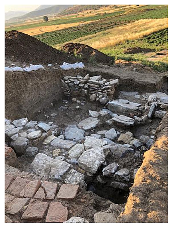 Space 5 is situated East of Space 4. It is limited in the North by the E-W running wall L.44.
This wall binds with wall L.43, running N-S.
Their eastern and southern boundaries should be in the balk. No access
to this space has yet been identified. It is striking that this space
is constructed with a separate wall towards the north. Therefore, a
structural sequence can also be assumed between Spaces 3 and 5. The
walls are preserved to a height of 6 or 7 courses. The width of both
walls is about 0.75 m, thus smaller than the northern wall of Space 4.
Space 5 is situated East of Space 4. It is limited in the North by the E-W running wall L.44.
This wall binds with wall L.43, running N-S.
Their eastern and southern boundaries should be in the balk. No access
to this space has yet been identified. It is striking that this space
is constructed with a separate wall towards the north. Therefore, a
structural sequence can also be assumed between Spaces 3 and 5. The
walls are preserved to a height of 6 or 7 courses. The width of both
walls is about 0.75 m, thus smaller than the northern wall of Space 4.Fig.9: View downslope (facing southeast) of Iron Age stone constructions revealed in Square 278689 and 278688.
Inside Space 5 a floor of stones and beaten mud abuts the two walls, but did not show any specific feature which might suggest its function. Although Space 5 was only partially exposed, its location near the entrance to Space 3 shows a strong relation to the entrance area. In Space 3, a door socket was found, which proves the lockability of the room. The width of the passage allows this passage to be regarded as a gateway. Space 4 may be an outdoor area. Space 5 could therefore have had a guard or control function.
Sasanian occupation
Space 1
A more recent occupation is represented by a floor (Locus:278689:011) composed of
regular, square and trapezoidal baked bricks measuring 28 x 28 x 7 cm. These dimensions fall well within the known range of baked Sasanian bricks from other sites in Iran and Iraq.
This floor lies directly on the brown-yellowish deposit L.13 which is bounded to the west by the stone wall L.8, to the east by the baked brick installation/wall (L.9) and to the south by the mudbrick wall/structure L.15 and L.17 South of this room, the wall is part of a larger structure (LGR:0002) for which no limit have been found so far even in the south western extension of square 278688.
The orientation of the section of the mudbrick structure recovered is NW/SE. Between some courses of mudbricks a kind of mortar was observed, made of large sherds lying flat, embedded in a yellowish sediment, and many small angular fragments of schist. The mudbricks are difficult to identify on plan. They consist of brown sediment tempered with schist and sherds. They are generally square (30-40 cm long x 8 cm thick). This mudbrick structure was set on two fill deposits (2788688:028 and 278688:025) covering the Space 3 stone structures and fill (278688:027).
To summarize, we can discern three occupation phases: 1) An occupation with a west-east wall, not excavated yet; 2) an occupation period that can be dated to the Early Iron Age, based on the pottery; and 3) a Sasanian occupation. It seems that during the Early Iron Age, a stone threshold bordered by two large drystone walls on both sides was part of an entrance giving access to the top of the mound. During the Sasanian period, there was an area (Space 4) measuring 2 x 5 m that may be part of a room or an open space on the southern slope of the mound.
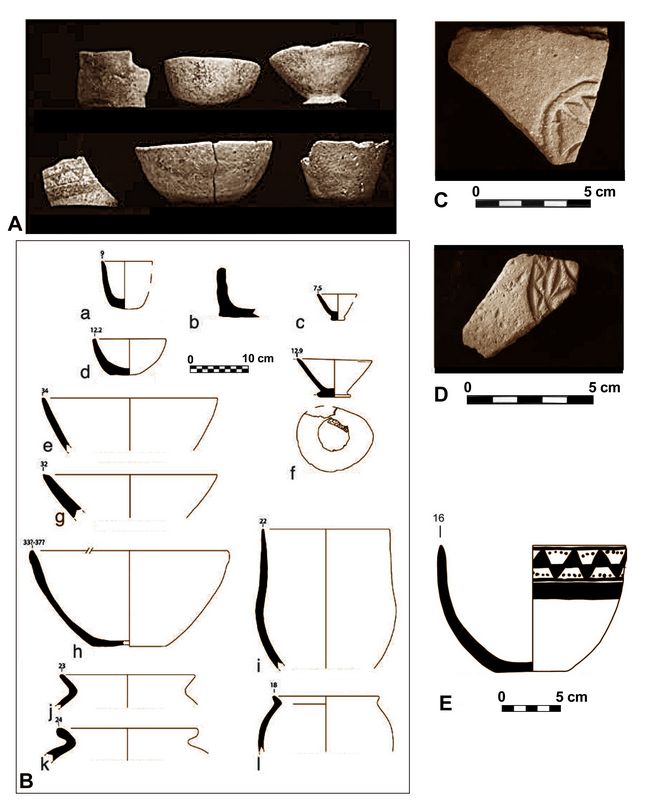 Pottery at Gird-E-Rostam
 In 2019, 517 sherds from the 2018 season were registered. As in 2018, every sherd found during excavation was kept. In 2019 we recovered 8025 sherds (1225 diagnostic sherds + 6800 non- diagnostic, c. 266 kg).
The 2019 season yielded the same types and fabric groups as 2018 in the deep sounding in square 278685 and in the squares 278688 and 278689 (fig.10).
Fig.10: Pottery types found at Gird-E-Rostam in 2018: A: Late Chalcolithic 1-2 vessels; B: a-l: Profiles of Late Chalcolithic 1-2 vessels; C & D: Die-stamped Sasanian pottery; E: Drawing of nearly complete, Ubaid-related Black on Buff bowl from locus 278685:-19/020 (after Potts et al., 2018, figs. 35,36,38,41).
Mid-5th millennium BC (LC1-2)
In the deep sounding in square 278685 we found the same types as last year with the
same fabrics. These included flaring rim jars for cooking pots, bowls with thinned rim
and “s” shape profile deep bowls, large flower pots and incurved rim bowls made with flattened coils (this last type may be residual from an as yet unidentified Neolithic occupation at the site, based on parallels at Neolithic Tol-e Nurabad in Iran, according to D.T Potts). A complete, inverted bowl was found at the very bottom of the sounding (Find:278685:026:006).
Late 2nd-early 1st millennium BC
In the fill L.27 and the deposit above the floor L.32, associated with the drystone wall architecture, pottery was found which has good parallels in the Dinka Settlement Complex Main Occupation Period (DSCMOP). Among the finds with parallels at Dinka may be mentioned a large broken tray belonging to the second phase of occupation in Space 3, made with large mineral inclusions and 2 cm thick coils; a flat lid with handle (Find:278688:027:004); and a burnished, carinated bowl (Find:278688:27:003) which shows the same technique as found in DSCMOP pottery (horizontal and vertical burnishing, wheel coiling technique). Other types with parallels in Western Iran, e.g. at Baba Jan, include an incurved rim pot with horizontal handles, thus far not recovered in DSC. We await more radiocarbon dates in order to confirm or modify this preliminary assessment of the chronology.
Sasanian period pottery
In the fill deposits beneath the mudbrick structure and within the mudbricks and mortar between the courses (LGR:0002) was a large quantity of Sasanian pottery. These include types already found in the 2018 season. Fabric groups A1 and A2 (schist based) were represented as well as double rim jar types, thick triangular rims and large-rimmed vats. A few turquoise-green glazed sherds with a light-colored fabric were also recovered in these contexts.
Geological fieldwork around Gird-i Rostam and in the district of Penjwin
Geological fieldwork was undertaken from July 16-23. The aim of the fieldwork was to work out more detailed information on the lithology and geological situation of the
surroundings of Gird-i Rostam than the existing geological maps provide. This is
necessary in order to bring the geological information on the region to a point where it
can aid in contextualizing the archaeological finds from Gird-i Rostam in their natural
environment and in ascertaining the availability of exploitable natural resources in
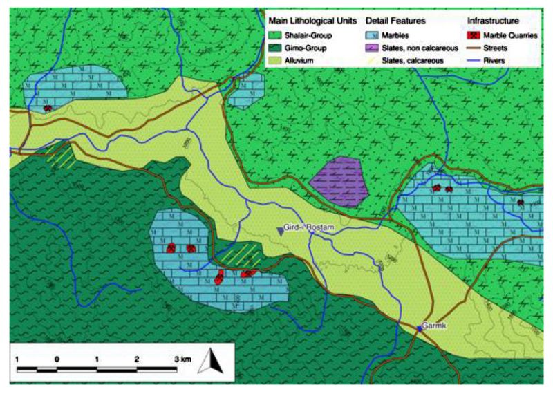 direct vicinity of the site. The work consisted mainly in field
survey, the differentiation and description of lithological units, and
the drawing of a geological map (fig.11). Secondly an extensive
field survey was undertaken to survey and, where possible, sample
mineral deposits around Penjwin for further analysis and in order to
estimate their possible value for ancient miners
direct vicinity of the site. The work consisted mainly in field
survey, the differentiation and description of lithological units, and
the drawing of a geological map (fig.11). Secondly an extensive
field survey was undertaken to survey and, where possible, sample
mineral deposits around Penjwin for further analysis and in order to
estimate their possible value for ancient minersFig.11. Preliminary sketch of the geology of Gird-i Rostam. Unless otherwise marked, the main units consist predominantly of phyllites and phyllitic schists.
References:
Adams, R.McC. 1981. Heartland of cities. Chicago: University of Chicago Press.
Bivar, A.D.H. and Fehévári, G. 1966. The walls of Tammīsha. Iran 4: 35-50.
Northedge, A. 2007. The historical topography of Samarra. London: British School of Archaeology in Iraq and Fondation Max van Berchem [= Samarra Studies 1].
Oates, D. 1968. Studies in the ancient history of northern Iraq. London: Oxford
University Press.
Potts, D.T. et al.. Gird-i Rostam 2018. Preliminary report on the first season of
excavations by the Joint Kurdish-German-American Team. Jaarbericht Ex Oriente
Lux 47: 91-127.
Radner, Karen 2021. A Bit of Assyrian Imperial Culture: The Fragment of an Inscribed Pottery Bowl from Gird-e Rustam (Iraqi Kurdistan). Altorientalische Forschungen 48(1): 119-124.
Rante, R. 2015. Rayy: From its origins to the Mongol invasion. An archaeological and historiographical study. Leiden/Boston: Brill.
Rekavandi, H.O. et al. 2007. An imperial frontier of the Sasanian empire: Further
fieldwork at the Great Wall of Gorgan. Iran 45: 95-136.
Shokoohy, M. 2011. Dayr-e Gačīn. Encyclopaedia Iranica Online Edition.
Unvala, J.M. 1928. Ancient sites in Susiana. Revue d’Assyriologie 25: 83-93.
.
Recent Foundation grants: general Archaeology Grants Program w/map
Copyright © 2022 Rust Family Foundation