Rust Family Foundation: Archaeology Grants Program
Tacora Archaeological Survey Project 2018
[RFF-2018-81]Principal Investigator: Dr. Noa Corcoran-Tadd
Faculty of Archaeology, Leiden University, Netherlands.
The great silver mining centres of Potosí, Porco, and Oruro in the Bolivian altiplano have long formed an important focus for understanding the Spanish colonial world, both within the colonial imagination and for the contemporary historian. As one of the primary sources of the tremendous mineral wealth extracted from the Americas during the colonial period, the mines of Bolivia provided silver to the rest of the Spanish colonial world via the Pacific port of Arica and a network of shifting routes known collectively as ‘the silver road’ or Ruta de la Plata (Glave 1989, López Beltrán 2016). However, the Ruta de la Plata remains little studied from an archaeological perspective with the result that this important and complex rural landscape is understood almost entirely from the urban colonial archive (Corcoran-Tadd 2019).
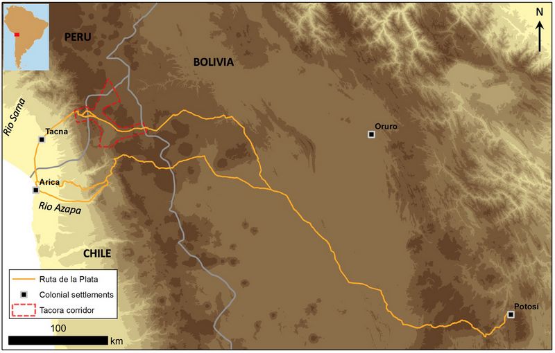
Fig.1: Map of the colonial Ruta de la Plata (silver road) and the location of the Tacora corridor project area.
The Tacora Archaeological Survey Project seeks to redress this imbalance by exploring the history of caravan-based mobility during the late prehispanic (c. AD 1000-1532) and historic (c. AD 1532-1920) periods in the south-central Andes. The project focuses on a strategic high-altitude (3800-4500m) corridor in the northern Chilean region of Arica y Parinacota that straddled the Ruta de la Plata. Centered around the contemporary indigenous settlement of Tacora and the headwaters of the Lluta drainage, the survey area forms a crossroads between the highland altiplano of modern-day Bolivia and the coastal valleys of northern Chile and southern Peru (fig.1). In 2018, the project used a combination of remote sensing, pedestrian survey, and GIS to explore this area as an archaeological landscape and to better understand the roles played by local pastoralist communities in the long-distance networks of the Inca and Spanish empires.
The project also emphasized the recording of a landscape under current threat from expanding mining operations in the region. Despite the important oversight provided by national heritage bodies, archaeological sites in the wider region of southern Peru and northern Chile continue to be severely affected by unchecked urbanization, infrastructure and mining projects, and looting, with sites in the remote highlands being particularly difficult to monitor. Given that many of the sites targeted by the project lie along several tightly bounded transport corridors connecting Chile with Peru and Bolivia, there is a clear threat from an expanding road network and several planned mining projects. Working in advance of these transformations of the landscape, the project aimed to record threatened sites through survey and photogrammetry of standing architecture.
Previous Work in the Region:
Several bodies of archaeological and historical research provide the background for the project. Over the past five decades, archaeologists based at the Universidad de Tarapacá in Arica (Chile) have conducted important archaeological research on the lower Lluta and Azapa drainages, providing a detailed baseline for understanding the pre-Inca and Inca settlement of the coastal and piedmont regions (Santoro 1983, Santoro et al. 2004, Santoro, Romero, and Standen 2009, Muñoz and Chacama 2006).
This work is complemented by unpublished cultural resource management reports on the archaeology of the neighboring highlands in Chile (Servicio de Evaluación Ambiental 2017), the project director’s previous survey (Proyecto Arqueológico Tambos de Palca) just to the west on the Peruvian side of the international border (Corcoran-Tadd 2017, 2019), and archival research on colonial settlement and trade routes through the area (Dagnino 1909, Rivera 1995, Pereira 2013). However, up until now, almost all of the archaeological research in the region has focused on the prehispanic period to the detriment of furthering our understanding many of the transformations of the colonial period.
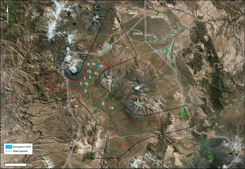
Fig.2: Map of the survey blocks completed during the 2018 field season
Current Funded Project (RFF-2018-81):
Goals:
The 2018 project had five primary goals:
• Goal 1: Intensive pedestrian archaeological survey will seek to locate road segments, waystations (tambos), caravan campsites, and local settlements in the area around the modern settlement of Tacora in the Arica highlands.
• Goal 2: Sites found during the survey will be recorded with GPS, tape and compass mapping, and photogrammetry where appropriate. Sites with clear and immediate threats from modern settlement, road expansion etc. will be prioritized for photogrammetric mapping.
• Goal 3: Sites and isolated finds identified in the survey will be dated in the field. Ceramics and other material cultural remains recorded on the surface provide an important basis for the relative dating of archaeological sites and road segments. Given that the survey is non-invasive, all remains will be photographed in situ for later analysis.
• Goal 4: Drawing on the analysis of the survey data (site distributions, site plans, onsite and offsite surface cultural remains), the project will explore evidence for continuities and transformations in settlement and mobility patterns in the regional landscape
• Goal 5: The project also aims to identify several sites for planned future excavation with an emphasis on locating stratified midden deposits.
Methodology:
Preparations for the project included a combination of remote sensing (systematic inspection of satellite imagery in Google Earth) and spatial analysis of the project area. Inspection of satellite imagery of the area located potential archaeological sites and abandoned road segments in the region. This work was being complemented by an GIS-driven analysis of the transport corridors in the wider Tripartito region (the area formed by the intersection of the borders of modern-day Chile, Bolivia, and Peru). Together these approaches provided a key baseline in locating specific blocks for targeted archaeological survey.
The survey blocks were surveyed with closely spaced pedestrian transects (15m spacing between surveyors) and with a handheld GPS and hand compass used to maintain transect spacing and bearing. Counts of offsite non-diagnostic artefacts (in the categories of ceramic, botija [ceramic transport jar], metal, and lithic) were recorded by surveyors every 50m and were input into the survey database using an iPad. Isolated surface finds were recorded separately including their GPS location, location photos, and photos of the artefacts themselves.
Sites were defined minimally as built features and/or diagnostic scatters from two or more artefacts, and with an apparent pre-1950 date. Identified sites were recorded using GPS, tape and compass mapping on millimeter graph paper, topographic context and built feature photos, photos for photogrammetry (if appropriate), and photos of surface artefacts. Sites also were evaluated for risk of disturbance or destruction.
Following a non-invasive methodology, no artefacts or samples were collected in the field. Archaeological sites and road segments encountered in the project were dated based on diagnostic artefact identifications made in the field. At larger sites, multiple locations across the surface scatter were sampled to provide a spatial control over the distribution of different activities and/or periods of occupation over the site. Photography of the artefact samples enabled the subsequent checking and refinement of stylistic identifications and dating.
Results:
During the July and August 2018 field season funded by the Rust Family Foundation grant, the project began the process of ground-truthing a series of potential archaeological sites and road segments across the Tacora corridor. During the field season, a total of twelve survey blocks (seven road segment blocks and five site blocks) were completed. The survey recorded a total of 22 archaeological sites and 14 isolated finds. Through this process, the survey provided a verification of some of the initial remote sensing results. While several of the sites were known from previous publications and reconnaissance visits, most of the sites (including the tambos at sites 017 and 020) were previously unknown. The ground-truthing also revealed one false positive identification, with site 023 turning out to be an entirely post-1950 settlement based on its surface scatter and architectural remains.
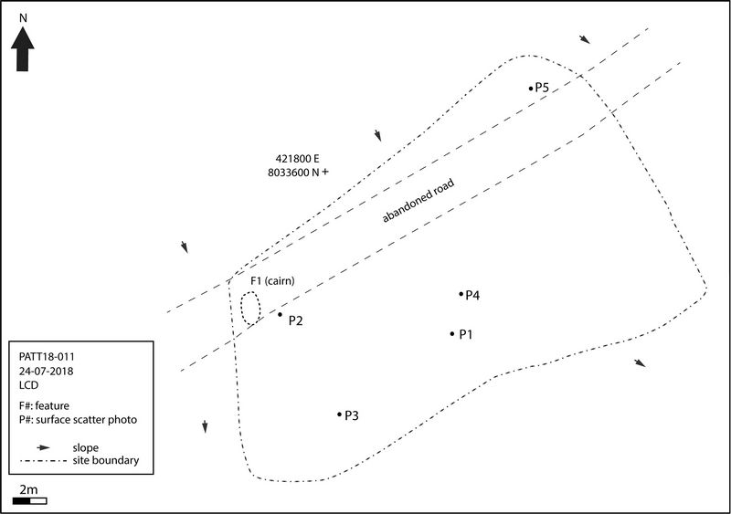
Fig.3: Map of colonial artifact scatter (site 011, block 2)
The abandoned road segments identified in the remote sensing were often entirely invisible from the ground, suggesting the importance of feedback between remote and on-the-ground methods in a survey of this kind. At the same time, the surface results from many of the survey blocks provided clear confirmation and dating for the road segments.
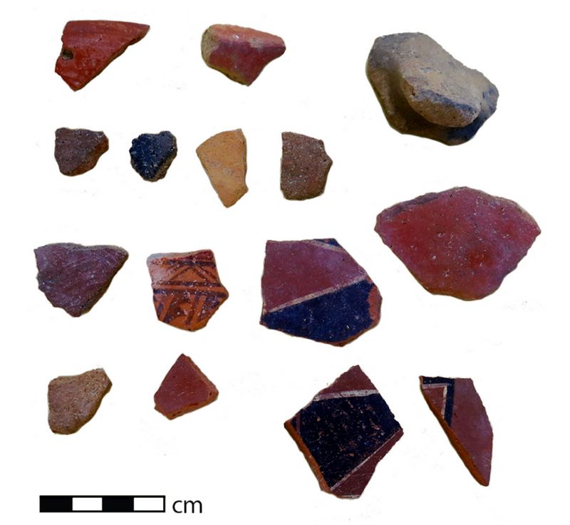
Diagnostic surface scatters were recorded to enable the initial dating of these sites and road segments, providing information on the changing patterns of landscape use and networks of mobility over the past millennium. Sites and finds were recorded dating primarily to the Late Intermediate Period (LIP; AD 1000-1400), the Inca Empire (AD 1400-1532; figs 4 and 6), the Colonial period (AD 1532-1824; fig.3), and the early Republican period (AD 1824-1920).
Broadly speaking, the project revealed se
 veral underlying patterns of long-term continuity and change
in landscape use and networks of mobility. First, many of the sites
showed evidence for multiple occupations, suggesting the long-term
emergence of ‘persistent places’ in the landscape. These were
likely the product of a mixture of both natural and anthropogenic
features of the harsh altiplano landscape.
veral underlying patterns of long-term continuity and change
in landscape use and networks of mobility. First, many of the sites
showed evidence for multiple occupations, suggesting the long-term
emergence of ‘persistent places’ in the landscape. These were
likely the product of a mixture of both natural and anthropogenic
features of the harsh altiplano landscape. Fig.4: Inca ceramics from site 015 (block 11)
Second, there appear have been important changes in settlement density in the project area across the long term. While estimating population change is difficult, given the non-random location and low number of the survey blocks, the survey results currently suggest a local decline in settlement during the colonial period with little investment in formal architecture. This was followed by major growth in the second half of the 19th century and the first half of the 20th century.
Third, the road segment survey blocks suggest overall continuities between the Inca and Colonial-period routes, with a strong emphasis on northeast-southwest c
 onnectivity. This route appears to have been
formalized with a chain of tambos initially in the Inca period. The
route also linked to the LIP settlement center of Tacora with its
evidence for pre-Inca ties with the coast, suggesting that the Inca
were able to capitalize on and formalize preexisting patterns of
coastal-highland mobility.
onnectivity. This route appears to have been
formalized with a chain of tambos initially in the Inca period. The
route also linked to the LIP settlement center of Tacora with its
evidence for pre-Inca ties with the coast, suggesting that the Inca
were able to capitalize on and formalize preexisting patterns of
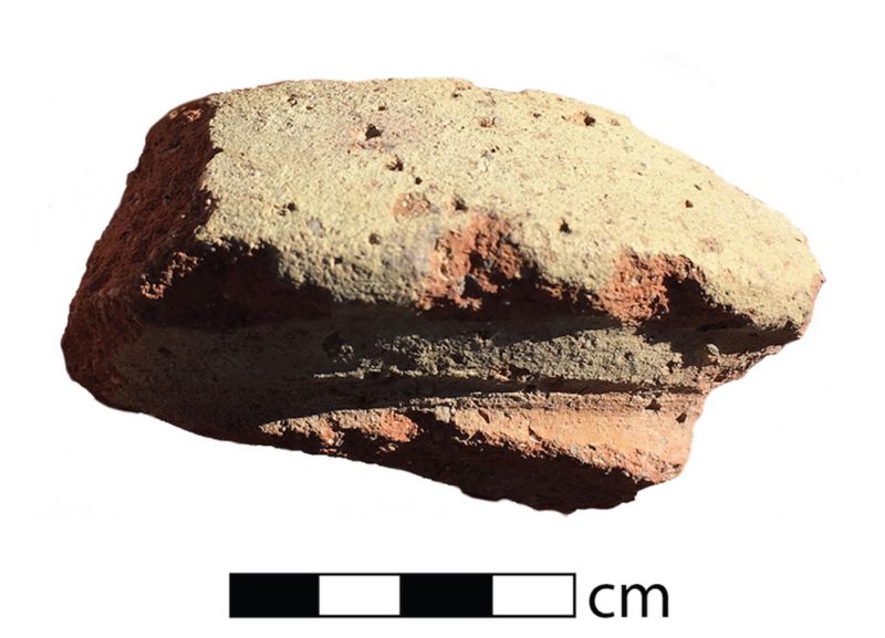
coastal-highland mobility. Fig.5: Botija jar rim from site 015 (block 11)
Low quantities of colonial material culture (primarily botija transport jars for wine and oil; fig.5) were recorded at abandoned Inca sites (fig.6) suggesting important continuities in the patterns of mobility through the region and providing material support for the view that the Ruta de la Plata caravans drew on a much longer legacy of mobility and infrastructure. The major discontinuities in the region cluster in the 19th century with important changes including the emergence of a second route branching near Tacora and extending to the southeast towards the Bolivian mining center of Oruro. Multiple new sites were constructed along both routes through the Tacora corridor including four new tambos, suggesting important growth in the volume of traffic in the late 19th and early 20th centuries.
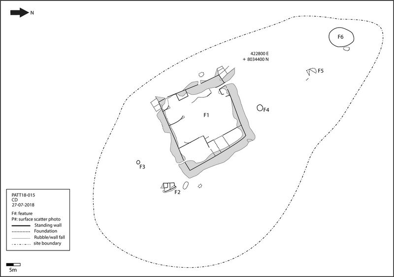
Fig.6: Map of Inca way station, site 015 (block 11)
Overall, the 2018 field season was largely successful in achieving its stated objectives. While the analysis of survey data is still ongoing, results have provided important initial insights into patterns of long-term settlement and mobility in the region. In addition, the survey project identified new locations for future study as well as initiated a new collaborative relationship with the indigenous communities and a regional NGO with the aim to highlight (and hopefully mitigate) current threats to the region’s archaeological heritage.
References:
Corcoran-Tadd, Noa. 2017. "Tambos and the Andean Longue Durée: Landscapes of Mobility in Far Southern Peru." Ph.D. thesis, Department of Anthropology, Harvard University.
Corcoran-Tadd, Noa. 2019. "Life beyond the city: historical and archaeological perspectives on colonial Andean mobility." In Power, Political Economy, and Historical Landscapes of the Modern World: Interdisciplinary Perspectives, edited by Christopher DeCorse. Albany, NY: SUNY Press.
Dagnino, Vicente. 1909. El correjimiento de Arica, 1535-1784. Arica: Imprenta La Época.
Glave, Luis Miguel. 1989. Trajinantes: caminos indígenas en la sociedad colonial. Siglos XVI-XVII. Lima: Instituto de Apoyo Agrario.
López Beltrán, Clara. 2016. La Ruta de la Plata de Potosí al Pacífico: Caminos, comercio y caravanas en el os siglos XVI y XIX. La Paz, Bolivia: Plural de Ediciones.
Muñoz, Iván, and Juan M Chacama. 2006. Complejidad social en las alturas de Arica: territorio, etnicidad y vinculación con el estado inca. Arica, Chile: Universidad de Tarapacá.
Pereira, Magadalena. 2013. "La evangelización en la Ruta de La Plata, Arica y Parinacota." Espacio Regional. Revista de Estudios Sociales 1 (10):31-44.
Rivera, Mario A. 1995. "Arica en las rutas del tráfico de Potosí: Algunas consideraciones sobre la sociedad andina del siglo XVIII." Revista Chilena de Antropología 13:99-136.
Santoro, Calógero. 1983. "Camino del Inca en la sierra de Arica." Chungará 10:47-55.
Santoro, Calógero, Alvaro Romero, and V Standen. 2009. "Interacción social en los períodos Intermedio Tardío y Tardío, valle de Lluta, norte de Chile." In La Arqueología y la Etnohistoria. Un Encuentro Andino, edited by John Topic, 81-142. Lima: Instituto de Estudios Peruanos e Institute of Andean Research.
Santoro, Calógero, Álvaro Romero Guevara, Vivien G Standen, and Amador Torres. 2004. "Continuidad y cambio en las comunidades locales, períodos intermedio tardío y tardío, valles occidentales del área centro sur andina." Chungará 36:235-247.
Servicio de Evaluación Ambiental. 2017. "Servicio de Evaluación Ambiental: Acceso al Sistema de Evaluación de Impacto Ambiental." accessed December 12. http://www.sea.gob.cl/.
Recent Foundation grants: general Archaeology Grants Program w/map
Copyright © 2019 Rust Family Foundation