Rust Family Foundation: Archaeology Grants Program
Dating the Clovis Era and Younger Dryas Western Stemmed Tradition at the Connley Caves (35LK50) in the Fort Rock Basin, Oregon
Principal Investigator: Dennis L. Jenkins
Archaeology Laboratory, University of Oregon.
Stephen Bedwell (1970, 1973) excavated in Connley Caves 1-6 in 1967-68. He obtained 21 radiocarbon dates on charcoal from the site. In caves 4-6 he recovered large Western Stemmed Tradition (WST) assemblages from deep deposits but also got inverted radiocarbon age determinations of 11,200 ± 200 BP from Level 32 (310-320 cm) and 10,600 ± 190 BP from Level 38 (370-380 cm) in Cave 4. The evidence of disturbance in these deposits and problems in dating accuracy originating at the 14C lab (Gakushuin University laboratory) cast doubt on the integrity and actual age of the cultural deposits at the Connley Caves.
The University of Oregon (UO) field school conducted investigations at the site during the 2000 and 2001 field seasons in an attempt to set the record straight through much more nuanced work. After a 12 year hiatus (2001-2013), during which the UO field school investigated the Paisley Caves, work resumed at the Connley Caves in 2014 and has continued through the summer of 2019. These investigations have focused on the geochronology and contextual reliability of deposits in caves 4 and 5.
In 2018, funding was awarded through grant RFF-2018-78 to help develop the Younger Dryas and earlier geochronological recor
 d at the Connley Caves
through 10 additional radiocarbon dates and 65 obsidian sourcing
and hydration results. Here, we report the results of the analysis of
samples drawn from excavations in previously undisturbed deposits in a
shallow rockshelter attached to the east side of Cave 5. The
investigations firmly establish the Younger Dryas age of the largest
and best dated WST assemblage in well stratified deposits in the
Intermountain West.
d at the Connley Caves
through 10 additional radiocarbon dates and 65 obsidian sourcing
and hydration results. Here, we report the results of the analysis of
samples drawn from excavations in previously undisturbed deposits in a
shallow rockshelter attached to the east side of Cave 5. The
investigations firmly establish the Younger Dryas age of the largest
and best dated WST assemblage in well stratified deposits in the
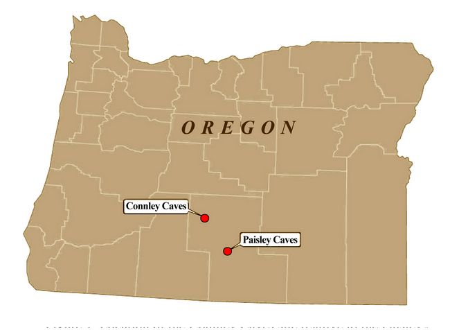
Intermountain West.Fig.1: Location of the Connley Caves site relative to the Paisley Caves in Lake County, Oregon.
Previous Work at the Site:
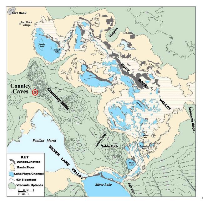
The University of Oregon archaeological field school has conducted two phases of excavations at the Connley Caves (35LK50) in the Fort Rock basin of south-central Oregon from 2000-2001 and 2014-2019 (fig.1). The site is composed of eight rockshelters and caves wave-cut by pluvial Fort Rock Lake (Allison 1979) into a south-facing ridge of Miocene welded tuff, rhyolite and basalt. At a mean elevation of 1356 m (4450 feet) the site is located in a juniper woodland on the lower flanks of the Connley Hills some two kilometers north of Paulina Marsh in the Silver Lake subbasin (fig.2).
Paulina Marsh is fed by Silver, Bridge, and Buck creeks, the only perennial water sources currently flowing into the Fort Rock basin. It empties into Silver Lake which is essentially a shallow marshy lake connected by a long series of channels and blow-out ponds extending north-northeast then west around the Connley Hills to join Paleo Lake Beazley (Schaub Lake and Beazley Lake combined) near the village of Fort Rock (Jenkins, Droz, and Connolly 2004:31). In other words, the Connley H
 ills are surrounded
by lowlands that have often filled with shallow lakes, ponds, marshes,
and channels throughout the past (fig.2). The hills were literally
an island at times during the Pleistocene and the caves are best known
as the central locality from which Stephen Bedwell developed the
concept of the ‘Western Pluvial Lakes Tradition’ (WPLT) (Bedwell 1970,
1973), later expanded by Hester (1973) to explain Terminal
Pleistocene/early Holocene (TP/EH) settlement-subsistence patterns
common throughout the Desert West.
ills are surrounded
by lowlands that have often filled with shallow lakes, ponds, marshes,
and channels throughout the past (fig.2). The hills were literally
an island at times during the Pleistocene and the caves are best known
as the central locality from which Stephen Bedwell developed the
concept of the ‘Western Pluvial Lakes Tradition’ (WPLT) (Bedwell 1970,
1973), later expanded by Hester (1973) to explain Terminal
Pleistocene/early Holocene (TP/EH) settlement-subsistence patterns
common throughout the Desert West. Fig.2: Location of the Connley Caves in the Fort Rock Basin.
Bedwell (1970) suggested that the ecological situation reflected a primary subsistence focus during the TP/EH on lacustrine resources, such as fish and waterfowl, and terrestrial animals occupying grasslands surrounding shallow, warm-water lakes and marshes. However, studies have since shown that the WPLT, as a foundational concept, draws too much attention to lacustrine resources and does not adequately account for sites often found in ecologically divergent settings. Consequently, it has gradually been replaced by the “Western Stemmed Tradition” (WST) which emphasizes shared technology sans the controversial ecological-subsistence constraints of the WPLT (Willig and Aikens 1988:28; Jenkins et al. 2016).
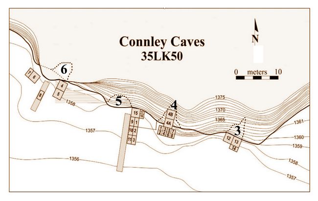
The Connley Caves contain deeply buried stratified TP/EH cultural deposits of the WST. While the site was occupied to varying degrees during the middle and late Holocene, deposits above the 7600 cal. BP Mount Mazama tephra lens were often disturbed by artifact miners prior to Bedwell’s investigations. This was the reason he gave for eliminating post-Mazama components overlying the TP/EH deposits he was most interested in. Bedwell employed a backhoe and manual shovels in the removal of 250 centimeters of deposits overlying pre-Mazama TP/EH sediments in conjoined 2 x 2 meter pits on a north-south axis inside caves 4 (units 4A & 4B) and 5 (units 5A & 5B; fig.3). He hand dug units in Cave 4 to a maximum depth of 390 cm, and those in Cave 5 to 350 cm, in 1967. In Cave 6, Bedwell’s crew manually shoveled off cow manure and vandal spoil dirt to an undetermined depth, then excavated a 1 x 4 meter trench on an east-west axis near the mouth of the cave to a depth of 280 cm. All units were hastily dug—removing 40 to 65 cm a day across 4 m2 units—with little supervision, in arbitrary 10 centimeter levels. The student excavators consistently recovered large WST stone and bone tool assemblages (Bedwell’s field notes 1967-‘68, UO Museum of Natural and Cultural History).
Bedwell’s excavations resulted in 21 radiocarbon dates ranging in age from 3080 to 11,200 BP. These dates were obtained from charcoal concentrations surrounded by artifact scatters. Each carbon sample was composed of ~5 grams of unidentified charcoal fragments.
Fig.3: Map of Connley Caves excavations.
Stratum 4, a thick, brown, silt deposit below the 7600 year old Mount Mazama tephra, near the bottom of the stratigraphic sequence, was dated between 4720 and 11,200 BP. Both of the latter dates were recovered out of stratigraphic sequence. The 11,200 BP sample, in particular, was recovered 60 cm above a younger sample dated at 10,600 BP. For ~50 years researchers have cited Bedwell’s (1970) dissertation and post-mortem publication (Bedwell 1973) even though they knew there were serious problems with the data (see Grayson 1979, 1993 for examples). Though the artifact assemblage and radiocarbon date sample was large, confidence in the Connley Caves data was justifiably low.
Current Project (RFF-2018-78)
Goals and Methodology:
To address the issue of the geochronology of WST cultural deposits, in 2018 we applied for and received grant RFF-2018-78 to pay for 10 radiocarbon dates and 65 obsidian sourcing and hydration (OH) measurements.
We began the analysis by selecting single fragments of point plotted charcoal found in the most reliable contexts possible, including two hearths surrounded by dense concentrations of WST artifacts and bone in Cave 5. We had these identified to family and genus prior to dating. The samples were dated by the AMS method.
Next, we selected the 65 obsidian specimens for source characterization (X-Ray Florescence) and hydration analysis relative to the radiocarbon dated samples. Obsidian is volcanic glass which adsorbs molecular water through time, developing a hydration rind that is visible under extreme magnification and polarized lighting. Comparing hydration rind thicknesses with calibrated radiocarbon dates allows one to estimate the rate of hydration and the relative length of time since the artifact was last flaked. However, the geochemistry of particular obsidian sources and exposure to temperature have dramatic effects on the rate of hydration. To control for geochemical variance between specimens we selected samples from the most common obsidian in site assemblages: the local Cougar Mountain source.
To control for the effects of temperature on samples we have initiated soil temperature analysis by recording the temperature every hour with ibuttons for three years. Ibuttons were set at depths ranging from 20 centimeters to 250 cm below the surface. The soil temperature data has yet to be processed and is currently unavailable. Here we simply present the obsidian hydration results from Cave 5 by depth and in probable association with radiocarbon dated charcoal samples.
Results from current project:
Geochronology of Cave 5: Radiocarbon Dates
Excavations in Cave 5 investigated a previously undisturbed, by either Bedwell or artifact miners, shallow rockshelter attached to the east side of Cave 5. This shelter connects the mouth of Cave 5 with the mouth of Cave 4 nearby. A broad crack in the cliff at this location has been colonized by woodrats for many thousands of years, resulting in extremely organic deposits rich in cultural material. This constantly renewed source of dry branches and twigs, collected by the rodents (Neotoma spp.), made the shallow rockshelter a convenient location to camp and build small fires. Excavations in this area in 2000-2001 and 2016-2018 recovered basketry, cordage, bone, charcoal, coprolites, hide, and lithics. Cultural deposits regularly reach depths around 300 to 350 cm. Our 2017 excavations encountered several well-defined hearths (a first for this site) surrounded by Cascade (serrated foliate) and Western Stemmed projectile points.
Radiocarbon dates for these artifacts and features are listed in Table 1. The 2018 hearth and projectile point dates funded by grant RFF-2018-78 are shown at bottom in black type, while those from previous excavations are in light blue type.
Table 1: Connley Cave 5 radiocarbon dates: 2000-2018.
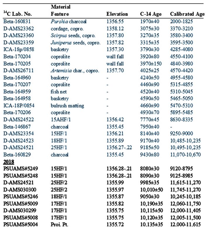
The sequence of dates obtained in 2018 indicates most excavation units were in 10,100 BP - 10,200 BP (ca. 12,000 cal. BP) aged deposits at a mean depth of 1355.70 meters above sea level (masl) at the beginning of the 2019 field season. A single fragment of Artemisia charcoal recovered near a Haskett style projectile in a dense WST cultural component at an elevation of roughly 1355.60 masl was dated to 10,310±40 BP (12,385-11,955 cal. BP). The 2019 field season continued excavations to a mean depth of 1355.05 masl. Stone tools were recovered to a mean depth of 1355.30 masl (1355.50 to 1355.15) and lithic debitage counts above five flakes per five centimeter level continued to a mean depth of 1355.20 masl (1355.35 to 1355.05). Sedimentary rate of accumulation is estimated at roughly 10 radiocarbon years per centimeter. If the sedimentary rate of accumulation remained constant during the early Younger Dryas this rockshelter was most likely first occupied between 10,500 BP and 10,600 BP (ca. 12,620-12,460 cal. BP).
Obsidian Source Characterization and Hydration
Obsidian is a glassy form of volcanic silica. Each obsidian flow tends to be geochemically distinctive. Light patterns (fluorescence) generated by X-Rays passed through an obsidian specimen indicate its chemical composition. A computer program then recognizes these patterns and assigns the specimen to a known or unknown source. Chemical composition affects the rate of adsorption of molecular water into the obsidian specimen. Therefore, it is necessary to know the assigned obsidian source prior to conducting obsidian hydration (OH). Exposure of fresh surfaces in the chipping process of stone tool production in effect sets the hydration clock to ‘0’. As time passes, adsorbed water builds up in the glass forming a rind measured in microns. Determining the rate of obsidian hydration (OH) is a difficult process that usually begins with comparison of hydration thickness with associated radiocarbon age determinations. To be accurately employed, this process requires the use of calibrated radiocarbon dates, which tend to be more linear than conventional radiocarbon ages.
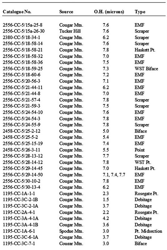
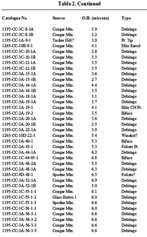
Table 2: Connley Caves 5 obsidian hydration results for the Cougar Mountain, Glass Buttes, Spodue Mountain, and Tucker Hill sources.
Soil and atmospheric temperatures also affect the rate of hydration. Higher temperatures increase the rate of hydration; lower temperatures slow it. Thus, exposure to high surface and near-surface temperatures causes rapid hydration while rapid and prolonged burial results in slow hydration. Proximity to exposed bedrock, cliff faces, and boulders which radiate adsorbed daytime solar heat during the night increases the rate of hydration. Thus, post-depositional settings and histories involving varying sequences of burial, exposure, and reburial result in variance in hydration rind thicknesses of specimens produced by the same lithic reduction event. Consequently, it is important to understand that individual hydration
 measurements are less
important than robust patterns of hydration spanning site occupations.
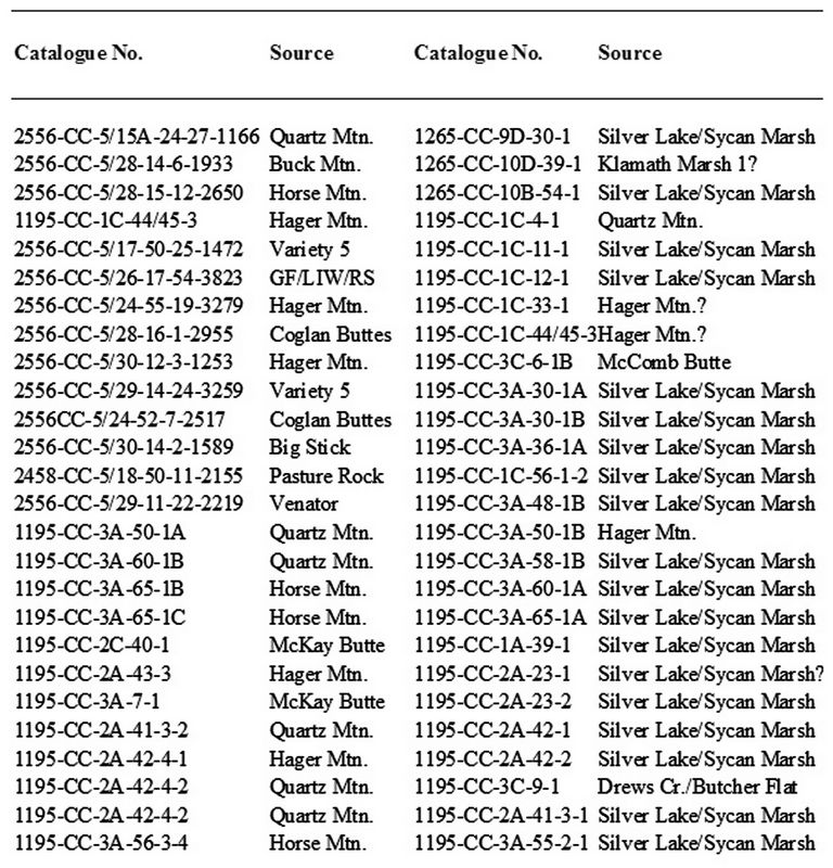
Obsidian source characterization by the X-Ray Fluorescence (XRF) method has been conducted on a total of 146 specimens recovered from all excavations in Cave 5 (2000-2018). Obsidian hydration analyses have been conducted on 92 specimens traced to the Cougar Mtn. (N=84), Glass Buttes (N=2), Spodue Mtn. (N=3), and Tucker Hill (N=3) obsidian sources (Table 2). Sources for which obsidian hydration results are not reported are Big Stick (N=1), Buck Mtn. (N=1), Coglan Butte (N=2), Drews Creek/Butcher Flat (N=1), GF/LIW/RS (N=1), Hager Mtn. (N=9), Horse Mtn. (N=4), Klamath Marsh 1 (N=1), McComb Butte (N=1), McKay Butte (N=2), Pasture Rock (N=1), Quartz Mtn. (N=8), Variety 5 (N=2), Venator (N=1), and Silver Lake/Sycan Marsh (N=19); totaling 54 specimens.
Table 3: Obsidian source only specimens.
 As is typical of
obsidian source characterization studies throughout Oregon the closest
source composes the vast majority of obsidian artifacts and debitage.
Cougar Mtn. is both close to the Connley Caves (ca. 21 km. to
the northeast) and an excellent obsidian source that composes 88% of
all tools and 94% of the lithic debitage in the Cave 5 assemblage
reported in Table 2. The Silver Lake/Sycan Marsh source is even closer
but is not as fine a stone tool source. It is more
coarse grained and contains phenochryst inclusions. Still, it was
extensively used, probably due to the fact that it is found all
around the Sycan Marsh and at the west end of Paulina Marsh some 17 km. from the Connley Caves.
As is typical of
obsidian source characterization studies throughout Oregon the closest
source composes the vast majority of obsidian artifacts and debitage.
Cougar Mtn. is both close to the Connley Caves (ca. 21 km. to
the northeast) and an excellent obsidian source that composes 88% of
all tools and 94% of the lithic debitage in the Cave 5 assemblage
reported in Table 2. The Silver Lake/Sycan Marsh source is even closer
but is not as fine a stone tool source. It is more
coarse grained and contains phenochryst inclusions. Still, it was
extensively used, probably due to the fact that it is found all
around the Sycan Marsh and at the west end of Paulina Marsh some 17 km. from the Connley Caves.The obsidian hydration (OH) results for the 92 specimens reported in this study range from 1.5 to 7.8 microns (µ). Table 4 compares OH measurements with depth below the surface as measured in 5 cm arbitrary levels. The deposits are generally soft and evidence of bioturbation (rodent and spade foot toad holes, in particular) is fairly common. Not surprisingly, therefore, obsidian hydration measurements and 14C dates on scattered charcoal are occasionally found to be out of stratigraphic sequence.
Table 4 indicates the proper ordering of OH measurements from the surface to the bottom of the deposits (ca. 300 cm). N= indicates the total number of measurements for that category; irrespective of the levels they were recovered in. (Dates in Red are out of stratigraphic sequence.) In general, measurements systematically thicken with depth but with a significant number of specimens (N=39; 42%) out of stratigraphic sequence to varying degrees.
Table 4: Summary of obsidian hydratiion measurements and radiocarbon dates obtained between 2000 and 2018 by excavation elevations.
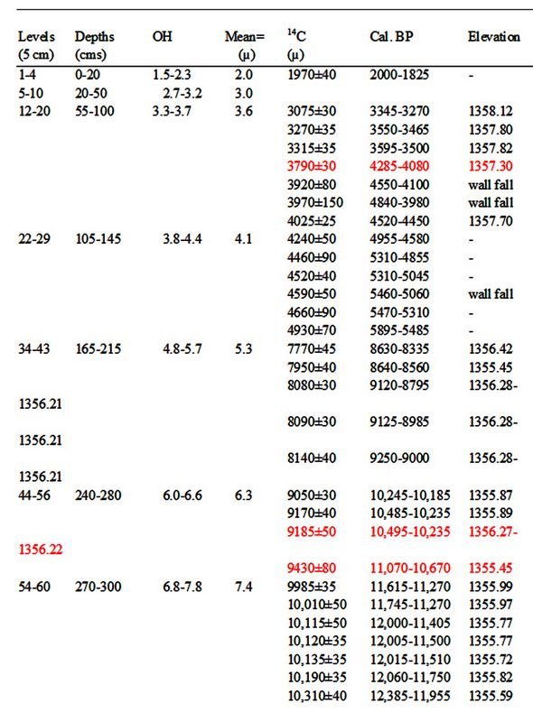
Pettigrew and Hodges (1995:2-16) proposed a hydration rate of 3.3µ2/1000 years for the primary obsidian sources in this region. Applying this rate to the Connley Cave 5 specimens suggests good correspondence between radiocarbon dates and OH measurements until OH measurements reach about 6.0 microns.
The thinnest measurements range from 1.5µ to 2.3µ (N=3; mean = 2.0µ), come from levels 1-4, and may be associated with a radiocarbon date ranging from 2000-1825 cal. BP (Table 1). This group includes two measurements (2.2µ, 2.3µ) on Rosegate arrow points known to date in this region to ca. 2000 years to the historic period. OH measurements of 1.5µ, 2.2µ, and 2.3µ suggest ages of 680, 1330, and 1600 years, respectively, forming a mean of ca. 1210 years. (Calculated ages are rounded off to the nearest decade.) This matches fairly well with a radiocarbon date of ca. 2000-1825 cal. BP and Rosegate arrow points dating to less than 2000 years.
The next OH group, recovered from levels 5-10 (20-50 cm), ranges from 2.7µ to 3.2µ (N=9; mean = 3.0µ). These measurements suggest ages ranging from 2210 to 3100 years with a mean of ca. 2730 years. There is no radiocarbon age paired with this group. Those in levels 12-20 (55-100 cm) have measurements ranging from 3.3µ to 3.7µ (N=16; mean = 3.6µ) and may be associated with seven radiocarbon dates ranging from 4840 to 3270 cal. BP. The OH measurements suggest ages ranging from 3300 to 4150 years with a mean of 3930 years. The mean of the likely associated radiocarbon ages is 3970 years. Those from levels 22-29 (105-145 cm) range from 3.8µ to 4.4µ (N=10; mean = 4.1µ) and may be associated with six radiocarbon dates ranging from 5895 to 4580 cal. BP with a mean of 5230 years. The OH measurements of this group suggest ages ranging from 5870 to 4380 years; forming a mean of 5090 years.
At this juncture in the stratigraphy there is a distinct break in radiocarbon and OH dates below Level 29. This break is most likely due to the presence of a massive deposit of culturally sterile Mt. Mazama tephra between levels 29 and 34 (145-170 cm). The eruption of Mt. Mazama has been repeatedly dated in this region to about 7600 cal. BP. OH measurements in levels 34-43 range from 4.8µ to 5.7µ (N=16; mean=5.3µ). These suggest a range of ages from 9850 to 6980 years and exhibit a mean of 8510 years. They may be associated with five radiocarbon age determinations ranging between 9250 and 8335 cal. BP which form a mean of 8910 cal. BP. OH measurements in levels 44-56 range from 6.0µ to 6.6µ (N=11; mean=6.3µ). It is here that the good to excellent congruence of calibrated radiocarbon and OH ages severely diverge. Applying Pettigrew and Hodges’ rate of hydration to measurements of 6.0µ to 6.6µ suggest a range of ages from 10,910 to 13,200 years forming a mean of 12,020 years. They may be associated with four radiocarbon age determinations ranging from 11,070 to 10,185 cal. BP with a mean of 10,450 years.
Notably, there are only two specimens with measurements of 6.2µ (8%) OH samples recovered since 2016 while there are 15 specimens (23%) with OH measurements in the 6.0µ - 6.9µ range in the 2000-2001 group. This suggests that the two sample sets are either not products of the same occupations, which is difficult to accept but not impossible, or the two groups have been subjected to varying environmental conditions which altered their hydration rate. Reasonably, the thickest measurements in the oldest deposits of each group should be approximately the same age.
OH measurements in levels 56-60 in units excavated between 2016 and 2018 range from 7.0µ to 7.8µ (N=22; mean=7.5µ). Applying Pettigrew and Hodges’ rate of hydration to these measurements suggests a range of ages from 14,850 to 18,440 years forming a mean of 17,050 years. These are closely associated with seven radiocarbon dates ranging between 12,385 and 11,270 cal. BP, forming a mean of 11,755 cal. BP. Bringing the two sets of dating techniques roughly together requires adjusting the proposed hydration rate to 4.7µ2/1000 years. That rate would place the lower end of measurements (7.0µ) at 10,430 years, the mean (7.5µ) at 11,970 years, and the thickest (7.8µ) at 12,950 years. This rate places the 7.8µ samples with a maximum age of ca. 13,000 cal. BP for the site—supported by radiocarbon dates in Cave 4—but it would match radiocarbon and OH dates for younger periods in Cave 5 very poorly.
Considering all of the chronological data together it seems most likely that something, possibly varying soil chemistry or localized exposure to high temperatures over a protracted period of time, caused OH to increase dramatically during or just after the earliest occupations of Cave 5.
Summary
Bedwell’s excavations were conducted hastily and in a fashion inadequate to the task of identifying mixing of cultural deposits. His radiocarbon dates for LU3 span nearly 4500 years between 8630 and 13,100 cal. BP. This is due to the crude dating methods of the 1960s requiring 5 grams of charcoal and Bedwell’s sampling techniques. He mixed scattered charcoal fragments and began dating just below the Mount Mazama tephra in disturbed contexts.
In 2014, we set out to investigate why Bedwell’s date of ca. 13,100 cal. BP was recovered 60 centimeters above a date of 12,600 cal. BP in Cave 4. We also wanted to define, date, and characterize the earliest cultural deposits at the site. We carefully investigated site formation processes, selected point plotted charcoal from reliable contexts, identified charcoal to family and genus, and only dated single charcoal fragments by the AMS method. We found that the earliest cultural deposits in the cave span a period of roughly 1,000 radiocarbon years. Our samples indicate there were two predominant periods of occupation in LU3 in Cave 4. The earliest occurred during the Clovis era between roughly 12,700 and 13,000 cal. BP. The later occupation between 11,750 and 12,340 cal. BP.
In Cave 5, the shallow rockshelter between caves 4 and 5, we continued excavations to determine whether there might be cultural deposits older than 13,000 cal. BP. The 2017 discovery of multiple hearths and high artifact density in this area suggested that it was a favorite location during the pre-Mazama period between ca. 8500 and at least 10,750 cal. BP.
Grant RFF-2018-78 provided in 2018 helped us tremendously by funding 10 radiocarbon dates and 65 obsidian source characterizations and the OH dating of the Cougar Mountain, Glass Buttes, Tucker Hill, and Spodue Mountain specimens. There are now 30 radiocarbon age determinations ranging from 1970 ± 40 BP (2000-1825 cal. BP) to 10,310 ± 40 BP (12,385-11,955 cal. BP) for the deposits of Cave 5.
OH measurements range from 1.5µ to 7.8µ. Matching these with the radiocarbon age determinations of corresponding strata required the development of two OH rates. Measurements between 1.5µ and 5.7µ match calibrated radiocarbon ages very well at the rate of 3.3µ2/1000 years suggested by Pettigrew and Hodges (1995). Pre-Mazama (>7600 years) samples with measurements between 6.0µ and 7.8µ require considerably more consideration. It is quite possible that these samples have hydrated at a much faster rate due to differing soil chemistry or extended exposure to higher temperatures. Certainly, the 2000-2001 samples have significantly differing OH measurements than those of 2016 to 2018.
The 2000-2001 specimens have a much greater representation of measurements in the 6.0µ to 6.9µ range (23%) compared to those of the 2016-2018 specimens (8%). They represent either very different chipping events or a dramatically increased rate of hydration for the 2016-2018 specimens. We believe the evidence indicates the latter with soil chemistry and/or extended exposure to increased temperatures requiring the development of an extremely rapid OH rate of 4.7µ2/1000 years to account for measurements in the 7.0µ to 7.8µ range. Clearly, while much has been learned about OH dating at the Connley Caves much remains to be done before this dating method is fully understood at this extremely important Western Stemmed Tradition site.
References cited:
Allison, Ira S.
1979 Pluvial Fort Rock Lake, Lake County, Oregon. State of Oregon Department of Geology and Mineral Industries Special Paper 7. Portland.
Bedwell, Stephen F.
1967- Field notes on file, Museum of Natural and Cultural History, University of Oregon, 1968 Eugene.
1970 Prehistory and Environment of the Pluvial Fort Rock Lake Area of Southcentral Oregon. Ph.D. Dissertation, Department of Anthropology, University of Oregon. Eugene.
1973 Fort Rock Basin: Prehistory and Environment. University of Oregon Books. Eugene.
Grayson, Donald K.
1979 Mount Mazama, Climatic Change, and Fort Rock Basin Archaeofaunas. In Volcanic Activity and Human Ecology, edited by Payson D. Sheets and Donald K. Grayson, pp. 427-458. Academic Press.
1993 The Desert’s Past. A Natural Prehistory of the Great Basin. Smithsonian Institution Press, Washington, D.C.
Hester, Thomas R.
1973 Chronological Ordering of Great Basin Prehistory. University of California Archaeological Research Facility Contributions 17. Berkeley.
Jenkins, Dennis L., Loren G. Davis, Thomas W. Stafford, Jr., Thomas J. Connolly, Michael Rondeau, Linda Scott Cummings, Bryan Hockett, Katelyn McDonough, Ian Luthe, Patrick W. O’Grady, Karl J. Reinhard, Mark E. Swisher, Frances White, Robert M. Yohe II, Chad Yost, Eske Willerslev
2016 Younger Dryas Archaeology and Human Experience at the Paisley Caves in the Northern Great Basin. In Stones, Bones, and Profiles: Archaeology and Geoarchaeology in Honor of C.V. Haynes, Jr. and George C. Frison. Marcel Kornfeld, Bruce B. Huckell, editors. The University Press of Colorado.
Jenkins, Dennis L., Michael S. Droz, and Thomas J. Connolly
2004 Geoarchaology of Wetland Settings in the Fort Rock Basin, South-Central Oregon. In Early and Middle Holocene Archaeology of the Northern Great Basin, edited by Dennis L. Jenkins, Thomas J. Connolly, and C. Melvin Aikens, pp. 31-52. University of Oregon Anthropological Papers 62. Eugene.
Pettigrew, Richard M. and Charles M. Hodges
1995 Prehistoric Hunter-Gatherer Land-Use Systems: Pacific Northwest. In Archaeological Investigations PGT-PG&E Pipeline Expansion Project Idaho, Washington, Oregon, and California, Michael J. Moratto, General Editor. Volume IV: Synthesis and Findings, edited by Randall F. Schalk, pp. 2-1-2-70. Pacific Gas Transmission Company, Portland, Oregon.
Willig, Judith A. and C. Melvin Aikens
1988 The Clovis-Archaic Interface in Far Western North America. In Early Human Occupation in Far western North America: The Clovis-Archaeic Interface, edited by Judith A. Willig, C. Melvin Aikens, and John L. Fagan, pp. 1-40. Nevada State Museum Anthropological Papers 21. Carson City.
.
Recent Foundation grants: general Archaeology Grants Program w/map
Copyright © 2020 Rust Family Foundation