Rust Family Foundation: Archaeology Grants Program
The Cochuah Regional Archaeological Survey
Principal Investigators: Justine M. Shaw
Professor of Anthropology, College of the Redwoods
Dr. Alberto G. Flores Colin
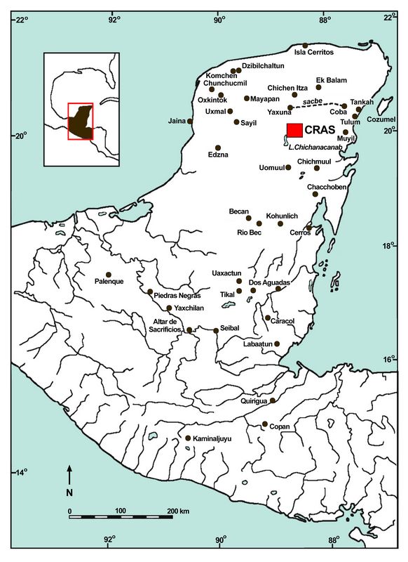
The survey region is located in the contact-period province of Cochuah (Roys 1965), in west-central Quintana Roo (fig 1). When the Cochuah Regional Archaeological Survey (CRAS) project began, development in the region was fairly limited, with most of the area occupied by modern Maya populations scattered in small towns and villages; most people made a living through agricultu
 re.
Archaeological sites were well protected on communally-owned ejido land
that was actually losing population to employment opportunities near
Cancun, Merida, and more distant cities. In recent years, however, the
situation has changed markedly, with local
population growth increasingly impacting the region. Heavy
equipment and casual use are destroying archaeological remains.
re.
Archaeological sites were well protected on communally-owned ejido land
that was actually losing population to employment opportunities near
Cancun, Merida, and more distant cities. In recent years, however, the
situation has changed markedly, with local
population growth increasingly impacting the region. Heavy
equipment and casual use are destroying archaeological remains.Fig.1: Map showing the location of the CRAS survey region in Mesoamerica.
As sites throughout the CRAS study area have been excavated, it is evident that much of the region was well populated by the Late Formative, with monumental constructions having been undertaken at sites including Yo’okop, Sacalaca, Yo’aktun, Sisal, and Ichmul during this period. However, although the crude measure of ceramic sherd counts gives the impression that the regional populations didn’t decrease, a definite settlement contraction occurs by the Early Classic with substantially fewer sites providing ceramics from this period. By the Late Classic, only the largest sites in the survey area (Ichmul, Sacalaca, and Yo’okop) appear to retain a significant population. If this patterning continues to be supported, it is believed to represent an attraction to these growing metropolitan areas, which would have been the increasing focus of civic (Adams 1991), ritual (Lucero 2003), and commercial (Dahlin 2009) activities.
Furthermore, better understanding the late Terminal Classic occupations of the region, evidenced in round foundation braces and open-fronted architecture, continues to be a focus of the project. This phase represents resilient populations that remained in the area in the immediate aftermath of societal collapse. The round foundation braces, distinct in style and content from round shrines found elsewhere (Aveni 2001; Harrison-Buck 2012), could represent shared granaries, apiaries, or novel domestic architecture.
Previous Work in the Region
Yo’okop (fig.2), located 12 km southeast of the modern pueblo of Sabán and 2 km northwest of Dzoyola in west-central Quintana Roo, had been the subject of several informal studies prior to when the current program of archaeological research was begun at the site. “[T]he first archaeological party ever” to visit the site, also known as Okop or La Aguada, consisted of journalist Gregory Mason and Herbert Spindon, of the Peabody Museum at Harvard University (Mason 1926). The pair traveled through the region with the assistance of chicleros in 1926, remarking upon the devastation that remained following the recent conclusion of the Caste War (Wren and Nygard 2015).
Under the auspices of the Carnegie Institution of Washington, Gustav Strömsvik, Harry E. D. Pollock, and Heinrich Berlin made a brief stop at Yo’okop, following a few days at the nearby site of Ichmul, in 1954. Strömsvik and Berlin returned three months later to spend several more days documenting some of the major architecture and monuments at Yo’okop (Strömsvik et al. 1955). Reginald Wilson, a missionary doctor, along with aviation pilots Jack Walker and Bill Clapp, made repeated visits to Yo’okop between 1966 and 1972 in order to locate and record additional monuments, note the existence of Sacbe 2, and survey Groups A and B. This resulted in Wilson’s 1974 publication, which expanded upon the work begun by the Carnegie Institution.
Archaeological focus didn’t return to Yo’okop until 1998, when Mexico’s Instituto Nacional de Antropologia e Historia (INAH) conducted basic reconnaissance and also made some surface collections at the site. Three seasons of fieldwork focused exclusively at Yo’okop began in 2000 and additional work as part of the Cochuah Regional Archaeological Survey from 2003 until the present has revealed much more of the site’s features, including the location of two additional sacbeob (Shaw 2015).
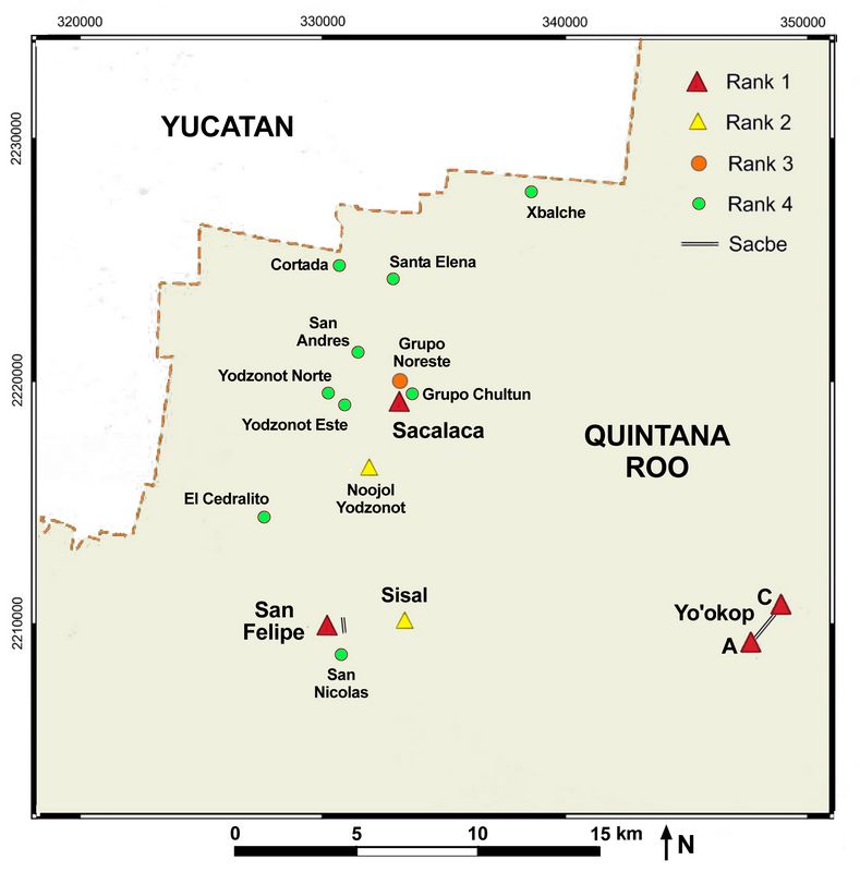 The Cochuah Regional Archaeological Survey (CRAS) has documented over 90
archaeological sites with occupations spanning from Middle Formative
through historic times. Prior to the
2018 field season 35 of the sites had been the subject of more
systematic study, including excavations and more thorough recording.
Others have merely been mapped, some have also been surface collected,
and a few only registered with the most basic data.
The Cochuah Regional Archaeological Survey (CRAS) has documented over 90
archaeological sites with occupations spanning from Middle Formative
through historic times. Prior to the
2018 field season 35 of the sites had been the subject of more
systematic study, including excavations and more thorough recording.
Others have merely been mapped, some have also been surface collected,
and a few only registered with the most basic data.Fig.2 Map showing sites surveyed in the 2018 CRAS survey. Yo'okop (lower right) was previously investigated.
Current Project (RFF-2018-70)
Original goals of the 2018 season:
• Map up to 31 undocumented sites with a total station and data collector
• 2x2m test pits at up to 10 untested sites.
In addition, “Puesto de la Aguada” near Yo’okop’s Group A, discovered in 2014, was to be further mapped and subject to 4 test pits and extensive excavations to better understand the sacbeob of Yo’okop were planned.
The season was envisioned to take place in three ejidos in which the project has worked for several years: Saban, Sacalaca, and San Felipe. Work began as planned in Sacalaca, with several new sites and groups being mapped and test pits emplaced at unsampled sites. Unable to secure permission to work in Saban, however, major components of the planned research had to be abandoned, and goals of the season were adjusted to include the excavation of a round structure and extensive excavations in the sacbe at San Felipe.
The former was designed to better understand the late Terminal Classic, when local populations had collapsed yet inhabitants remained in small numbers, while the latter sought to understand the relationship between roads and other features, as well as the functions that took place upon and adjacent to causeways. Excavation of the round foundation brace was designed to better explore this feature class, believed to date to a time following the primary Terminal Classic occupation based upon the stratigraphic relationship between the round structures and diagnostically Terminal Classic architecture.
It was once hypothesized that the latter buildings might represent Postclassic residential occupations, which have thus far been largely absent in a region in which Postclassic ritual activities and features are relatively common. However, past excavations did not reveal an occupational phase that could be chronologically distinguished from the Terminal Classic using ceramic types alone, although the 2018 excavation clearly demonstrated that it stratigraphically post-dated the Puuc-style Terminal Classic occupation, whose cut stones were found within structure and living surface sub-surface fill.
Extensive sacbe excavations at San Felipe were also designed to take a much more detailed look at features that had only been examined through basic clearing and mapping, as well as in test pits aimed more at uncovering vertical stratigraphy within site cores. These revealed a much more complex stratigraphic relationship between the sacbe and features that pre-dated the roadway and were incorporated into its construction, and those that may have been post-construction modifications. As with the structure, much smaller excavation sub-units, more detailed in situ mapping, and the collection of soil samples have already begun to produce much more information than prior work had done.
Although more work had been done within Sacalaca and San Felipe than in other ejidos, numerous sites have yet to be documented or excavated. The number of such unstudied sites and groups was reduced this season. In the ejido of Sacalaca, test pits were excavated at Cortada, Grupo Noreste, Santa Elena, San Nicolas, Yodzonot Este, Yodzonot Norte, and Yodzonot San Isidro. Maps of previously unknown major groups around the site of Sacalaca (Ak Group, Bech Group, Chultun Group, KanNi Group, and Plataforma Este) and the sites of San Andres, San Andres Norte, Sacalaca Trinchera, and Xbalcheil were produced. In the ejido of San Felipe, El Cedralito was mapped and test pits were excavated at San Nicolas.
Methodology
The 2018 Cochuah Regional Archaeological Survey (CRAS) involved archaeological research of the ejidos of Sacalaca and San Felipe.
Mapping:
More detailed mapping had been done using a Topcon GTS-213 total station with a TDS-48 data collector. Topographic relief, as well as any in situ archaeological elements, was recorded. The resulting maps are presented with a 50-cm contour interval (unless otherwise noted) in order to display some subtle terrain changes. Crews from each ejido were hired to clear all features to be mapped and to help locate features. Due to the structure location procedure, mapping generally began near a large mound and proceeded to the surrounding territory as time permitted.
Excavation:
2x2 m test pits were undertaken in the plaza(s) of several of the sites investigated this 2018 season. These plaza area excavations were aimed at providing ceramics from sealed contexts that could be used to date the sequence of constructions in a given area, as well as to determine the number and characteristics of such plaza flooring and occupation episodes. Test pits were excavated in natural levels and concluded at bedrock unless otherwise indicated, with materials separated according to the operation/ level/ lot system.
The structural excavation at Sisal was divided into 50-cm lots using a grid of stings. A cruciform set of unexcavated lots was utilized in order to permit internal stratigraphy to be documented, with these lots then being excavated to reveal the entirely of the extensive area. Once exposed, all architectural elements were consolidated using a mix of white cement, sascab, and cal, which was then painted a tone mimicking nearby soil using local sediment. Following all documentation, the structure was backfilled to protect it.
The two burials uncovered during the course of excavating Sisal’s Operation 8 were brought to UADY’s Bioarchaeology Lab under the direction of Dr. Vera Tiesler.
Artifacts from the excavations and surface collections were washed and marked with the site, operation, level, and lot. The Project utilized digital photography, plan and profile maps, and extensive note-taking in addition to the registry forms to record remains visible on the surface and in excavations. Upon completion and/ or at particularly important points in the excavation, a series of additional digital photographs were taken in order to permit photogrammetry (3-D virtual reconstruction) using Agisoft Photoscan Standard Edition (v. 1.4.2).
Sherds were identified to the variety level whenever possible, using the type-variety system (Smith et al. 1960). For the first time, each ceramic lot was also individually weighed, as well as having sherds identified and counted, in order to provide a better idea of actual sherd density and average sherd size. Lithics were measured in terms of length, width, and thickness; identified by material and functional type; and then had their Munsell colors recorded. All artifacts were brought to INAH-QR in Chetumal to be stored upon completion of the field season.
Sacalaca, Grupo Áak
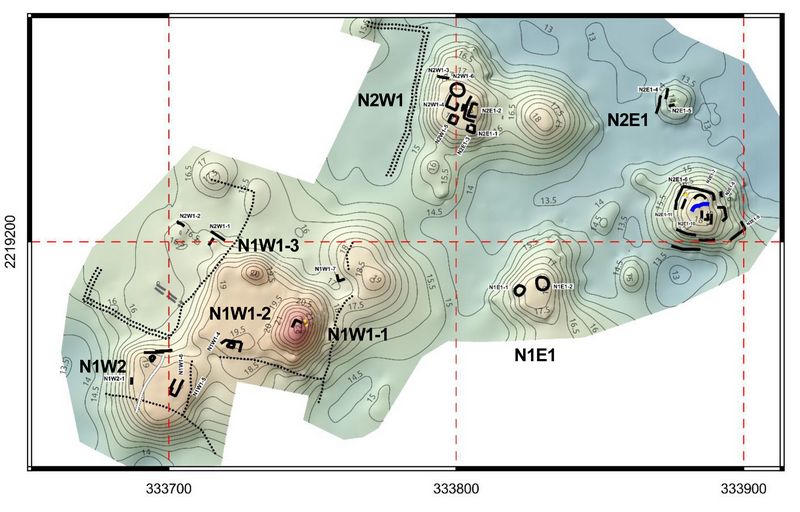
Fig.3: Plan of Grupo Áak at Sacalaca.
This architectural complex (fig.3), named for the Yucatec word for "turtle" (Áak), is located just 700 m from the center of the current town of Sacalaca, which would have been the center of the Prehispanic settlement of the same name. Between both areas it is possible to see platforms and foundations braces in the lots of several houses that are on the road between the central part and this group, which indicates that there is a continuous, but dispersed, settlement. In addition to this, throughout the area, there are also a series of features, albarradas (dry walls) delimiting properties, roads, streets, which were built during the colonial occupation and the period before the Caste War when Sacalaca was a much larger village than it is today.
The largest construction of the site is a rectangular platform of about 45 x 35 m (Structure N1W1-2), which is the base for pyramidal structures (Structures N1W1-1 and N1W1-3), located at its eastern and northern ends. Structure N1W1-1 contains the remains of a construction on its summit, and it seems that its front faces west, towards the center of Sacalaca.
The pattern that was revealed with the mapping of Grupo Áak, as well as in other areas that are part of the site of Sacalaca (i.e., Grupo Noreste, Grupo Chultun, and Grupo Kan Ni), shows that the settlement was distributed across the series of limestone hills that surround the site, leaving the low and humid areas for agricultural labors.
Unlike the southern terrain of our study area, where the relief is flatter, in the area where Sacalaca is located the surface is quite rugged, with small hills that alternate with low-lying areas or rejolladas that are characteristic of relief in the northern area of the Yucatan Peninsula. The settlement pattern observed in this group, as well as throughout the Prehispanic settlement of Sacalaca, reflects how the low terrain was dedicated to crops, while the rocky hillocks were for buildings, most of them adapted and modified to take advantage of their characteristics to use it more efficiently. The structures that make up this group are of different sizes and most of them are settled on limestone outcrops that were totally or partially modified (fig.3). Between these outcrops of limestone, there is a series of low depressions, which reveal a reddish earth (locally called chak lu'um) and which retain a higher humidity; this makes them ideal for seasonal agriculture. In fact, in some sections of the area that was mapped, there were crops from the current inhabitants of Sacalaca.
Sacalaca, Grupo Noreste
Grupo Noreste (Northeast Group) is located about 700 m from the center of the town of Sacalaca (fig.4). This complex had already been registered in 2003 by several project members (Shaw 2003: 43-56). However, on that occasion, only part of the main complex was registered. Therefore, this season it was decided to continue with the task of registering the group in addition to conduct three test excavations (Operations 1, 2, and 3).
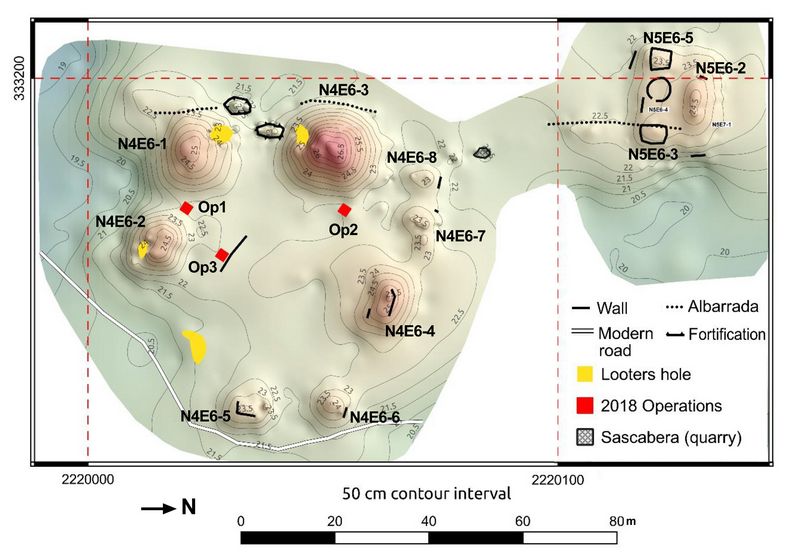
Fig.4: Plan of Grupo Noreste at Sacalaca.
Among the constructions that were registered this 2018 season are Structures N4E6-5 and Structure N4E6-6, which are two range structures that mark the eastern part of the elevated plaza of the Grupo Noreste is based. Both constructions are not very well preserved and only conserve some remains of the walls that delimited their top. About 20 m to the southwest of these constructions was located a looters’ hole, from which stone seems to have been extracted to be reused in some construction or nearby albarrada (dry wall).
Another area that was registered this season was the northern part next to Structure N4E6-3, the largest pyramidal structure in the group, where two range structures were located that were aligned parallel to each other (Structures N4E6-7 and N4E6-8). The arrangement of these constructions somewhat resembles a ball court (two low, parallel range structures); however, there are no constructions where the ends of the long sides of the court would have been located.
About 12 m to the north of this area there is a sascabera, which is larger than it appears on the surface since it continues for several meters underground. About 35 m further north, a rectangular platform, Structure N5E7-1 was located, which has several superstructures at the top. This construction has a few remains of its walls, mainly on its southern and eastern sides, as well as the remains of a stairway through which the surface was accessed on its southern side.
Among the superstructures is the Structure N5E6-2, a range structure about 2 m high, as well as two small platforms (Structures N5E6-3 and N5E6-5) that seem to have had perishable constructions on their summits. In the middle of these structures, a circular foundation brace of about 5 m in diameter was located. In addition, we registered a number of albarradas that seem to be delimiting a series of lots dating to the Colonial occupation or from the Caste War.
Additionally, a non-systematic survey was carried out, following some local roads that go to the south and east of this group, where several platforms and perishable foundation braces of different sizes are dispersed in the area. All these remains, as well as those in the Grupo Aak, Grupo Chultun, and Grupo Kan Ni would have formed part of the major site of Sacalaca, indicating that this settlement was much larger than originally believed.
Sacalaca Grupo Noreste, Operation 2
Operation 2 of Sacalaca Grupo Noreste was a 2x2 m unit located between Structure N4E6-1 and Structure N4E6-2 (Shaw 2003), in the southern area of the plaza. In the topmost level of 6-10 cm depth, sherds with borders and ceramic bodies of the types Yokat Striated and Muna Slate from the Terminal Classic period were located. In underlying Lot 2, ceramics were of several types, although Sierra Red was the most abundant. Other samples included Corrugated Altamira and Black Polvero, all of them belonging to the Late Formative period. Below this, Lot 3 with a thickness of 8 to 21 cm, included Terminal Classic Ticul Thin Slate pottery. Bedrock was reached at a depth of 34 cm from the surface.
Sacalaca Grupo Noreste, Operation 3
Operation 3 was a 2x2 unit located directly to the east of Structure N4E6-3. The surface of the unit was covered with a yellow-red (10YR 2/2) sediment that represents subfloor fill from what had been a plaza flooring episode that had eroded long ago. Level 1, Lot 1 was excavated through this. Ceramics included a mix of types from the Middle Formative through the Early Classic, with the latest materials dating to the Terminal Classic. An original floor surface revealed in Level 2, Lot 1, with a redder (7.5YR 3/4), more compact sediment with small pebble inclusions. Ceramics in the fill were predominantly from the Middle and Late Formative, although some Terminal Classic ceramics were also present. Bedrock was uncovered at depths of 70-90 cm below the current ground surface. Based upon the ceramics, the fill was brought in during the Terminal Classic from contexts with earlier occupations.
Sacalaca Grupo Noreste, Operation 4
Operation 4 was positioned to the south of a single-course wall line to the east of Structures N4E6-1 and N4E6-3. Level 1, Lot 1 at 2-15 cm below the modern ground surface ended at the top of the large rock/ boulder component of the subfloor fill. Ceramics from this deposit date to the Middle and Late Formative. Level 1, Lot 2 yielded eight sherds dating to the Middle and Late Formative were included in this fill. At a depth of 67-86 cm below the ground surface (Level 2, Lot 1) the fill of the unit changed. The space between boulders and rocks became filled with sediment, representing an unusual plaza fill which would have required considerably more effort and material than dry core fill. However, it raised the plaza floor by an additional half meter and would have certainly provided a very solid base for the layers above it. Few ceramics, which dated to the Middle and Late Formative, were included in the sediment.
This fill rested upon what had likely been the original ground surface (Level 3, Lot 1), an extremely compacted, dense, dark red (2.5YR 3/6) sediment mixed with pebbles.
Level 3, Lot 1 contained somewhat more ceramics than the fill between the boulders above it; these dated to the Middle and Late Formative. Ceramics were not merely near the top of the level; they continued to be discovered near bedrock itself. This irregular bedrock was reached at a depth of between 1.3 and 1.6 m below the surface indicating that this had once been a markedly lower surface than either of the adjacent units.
When combined, the three units from Sacalaca’s Grupo Noreste reveal that what initially appears to be a relatively small outlying group to the north of the main core of the site was actually an occupation of relatively long – though not necessarily continuous – duration and that considerable effort was made to transform undulating terrain into an extensive, continuous, flat plaza surface that was ringed by moderate public architecture.
San Felipe
The site of San Felipe is located in the town that gives its name, where it is common to find Prehispanic remains in most of the properties of the settlement. The central core of the site is located 450 m from the modern town’s center, but only 140 m from the boundary of the current area of the population. This settlement has been documented by the CRAS Project since 2005 (Lloyd 2005; Shaw and Flores Colin 2008) and consists of two main groups (the North and South Group), although there are several components scattered about 2 km around the core. Prior to this season a total of 13 operations has been carried out at the site, 11 of which were test pits, while the rest were extensive excavations (see Flores et al., 2015).
Sacbe 1, Operations 14, 15 and 16
In 2018 three additional excavations, Operations 14, 15 and 16, documented the dimensions of Sacbe 1, placed across the sacbe to determine its physical limits.
Operation 14 and 16 were at the intersection with the terminal plaza, while Operation 15 was located in the central part, at the location of a sort of ramp with two nearly parallell small square structures.
Once vegetation was cleared excavation areas of 16x2m were subdivided into 8 sub-operations of 2x2m. In some areas, the sacbe was visible on the surface, requiring excavation only a few centimeters below the ground level. All the architectural features located during the excavations, including the side walls of the road and the platforms, were consolidated to ensure their conservation.
Operation 14
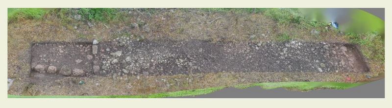
Fig.5: Overview of Operation 14 in Sacbe 1 at San Felipe.
Operation 14 (fig.5) was located in the northern area of the causeway, just before the plaza or ramp that provides access to San Felipe’s North Acropolis. On the surface, only an alignment of stones that indicated the west wall was observed, while in the east there were two possible alignments that could have been the retaining wall of this construction. In the area of the causeway (sub-operations A2 to A7), excavations proceeded until the layer of gravel or chich was located; this was excavated in order to remove the sediment that existed between the rocks.
In Level 1, Lot 1, despite the few centimeters in depth excavated, it was possible to recover more than 350 pottery sherds, mostly eroded due to their proximity to the surface. A little more than half of the fragments could be identified, including Terminal Classic types Muna Slate and Yokat Striated, Saban Unslipped from the Early Classic, and Sierra Red from the Late Preclassic. Similarly, Level 1, Lot 2 had samples of Yokat Striated and Muna Slate. plus mixture of examples of Altamira Fluted and Sierra Red from the Preclassic.
Level 1, Lot 3 reached 30 cm in depth, until the stones that formed the wall of this platform were reached, corresponding to the ancient occupation surface. Ceramics located in this layer belonged to the Terminal Classic types Muna Slate and Yokat Striated. Removal of Level 1, Lot 3 revealed that the platform, Feature 2, was not attached to the sacbe, but predated it,as the road crossed over it. In uncovering stones of the wall (Feature 3), two well-cut stones were found adjoining the wall, perhaps placed as a step (Feature 4). The ceramics from this lot were mostly Terminal Classic, and included examples of the types Yokat Striated and Muna Slate.
The excavation continued as Level 1, Lot 4, which revealed several stones in the northwest part and adjacent to the wall. the underlying Level 1, Lot 5 was a sediment similar to the previous deposit, although with the presence of numerous gravel stones that were located throughout the unit. An alignment was discovered that appeared to be a corner of a platform (Feature 5). The ceramics continued to belong to the Terminal Classic, including Yokat Striated and Muna Slate, plus a mixture of types from the Classic and the Late Preclassic. Level 1, Lot 6 reached a stucco floor (Floor 1), upon which Feature 5 was seated. This platform had two levels of stone and preceded the construction of the road, which crosses it completely above. With the discovery of this floor, the excavation was completed
Sisal
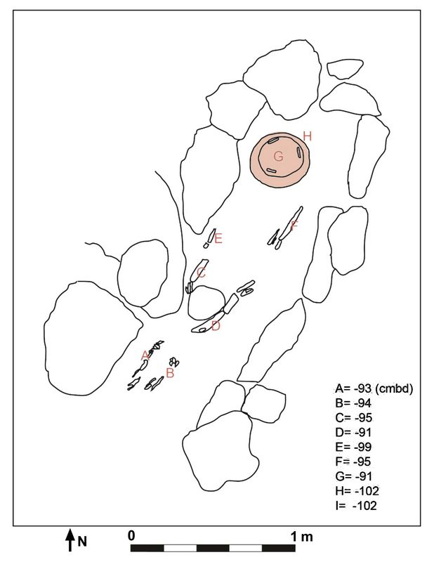
Structure N2W2-1, Operation 8
Structure N2W2-1 is a 3.5-m-wide, round foundation brace in the settlement zone to the east of Sisal’s acropolis (fig.6). The structure was selected as a means to explore the activities that took place in this, and potentially other, round structures. Based upon the typical stratigraphic relationship between such round structures and other features, it was hypothesized that Structure N2W2-1 would date to the late Terminal Classic; this architecture typically post-dates the Puuc-style constructions at sites in the Cochuah region. However, ceramically, it has not been possible to distinguish the latter phase from that of the primary component of the Terminal Classic. Some round structures do not seem to have served a domestic function based upon features such as the presence of protruding bedrock in the middle of the foundation brace, while others were probably houses (Johnstone 2014). It seems that the form is more characteristic of the time period, rather than typifying a singular function or activity.
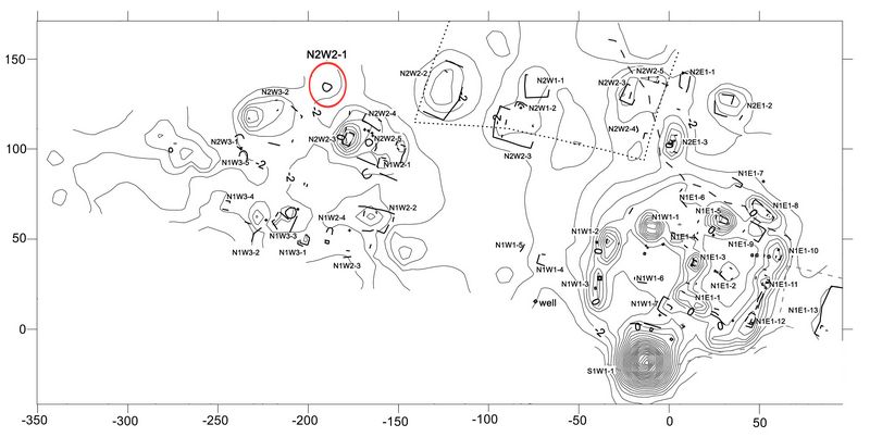
Fig.6: Plan of Sisal, showing the location of Structure N2W2-1 (red circle).
In order to better understand whether or not specific activities were focused spatially, a 9x9-m area was gridded out across and beyond the structure, with its center focused upon the central point of the structure. Level 1, Lot 1 consisted of removing between 22 and 39 cm of fill sediment, which contained many ceramic sherds and varied lithics. The large quantity and size of sherds was unusual relative to other areas excavated by the CRAS project. Most pottery dated to the Terminal Classic, with by far the most common type being Yokat Striated and Muna slatewares .
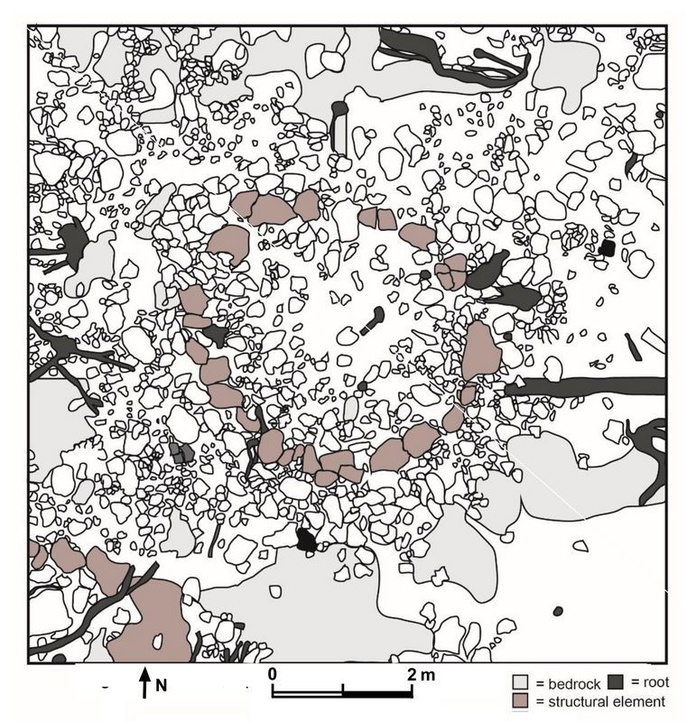
The removal of this first deposit revealed an extensive array of rocks across the excavated area. In the southwest corner of the excavated area, a portion of another round structure, built of extremely large rocks, was uncovered, with two courses of stones (Structure N2W2-6).
Level 1 revealed that the primary structure, N2W2-1, had included much more building material than was evidenced on the surface, comprising a thick wall that may have been as tall as one meter (fig.7). Upright stones forming a probable doorway faced directly to the north. Level 2, Lot 1 included the removal of collapse material from the interior and exterior of Structure N2W2-1, which included at least 12 cut, Puuc-style stones likely taken from structures within 1-200m of Structure N2W2-1. The presence of these cut stones at the base of Level 2 within and outside the structure indicated that the vast majority of the fill present was put there during the late Terminal Classic. Ceramics from this period as well as lithics were recovered
 in the course of removing the collapse and uncovering the
original occupation surface.
in the course of removing the collapse and uncovering the
original occupation surface. The excavation of Level 2, Lot 1 revealed that bedrock was quite close to the surface in the majority of the 9-m2 excavation. The bedrock was uneven and contained frequent holes and depressions reaching a greater depth of 20 or more cm below the remainder of the surface. Excavations were halted at about 52 cm below the surface in order to not endanger the stability of the structure walls. The considerably deeper western half had been filled in with stones and sediment containing both Terminal Classic ceramics and lithics.
Fig.7: Plan of Structure N2W2-1 at Sisal.
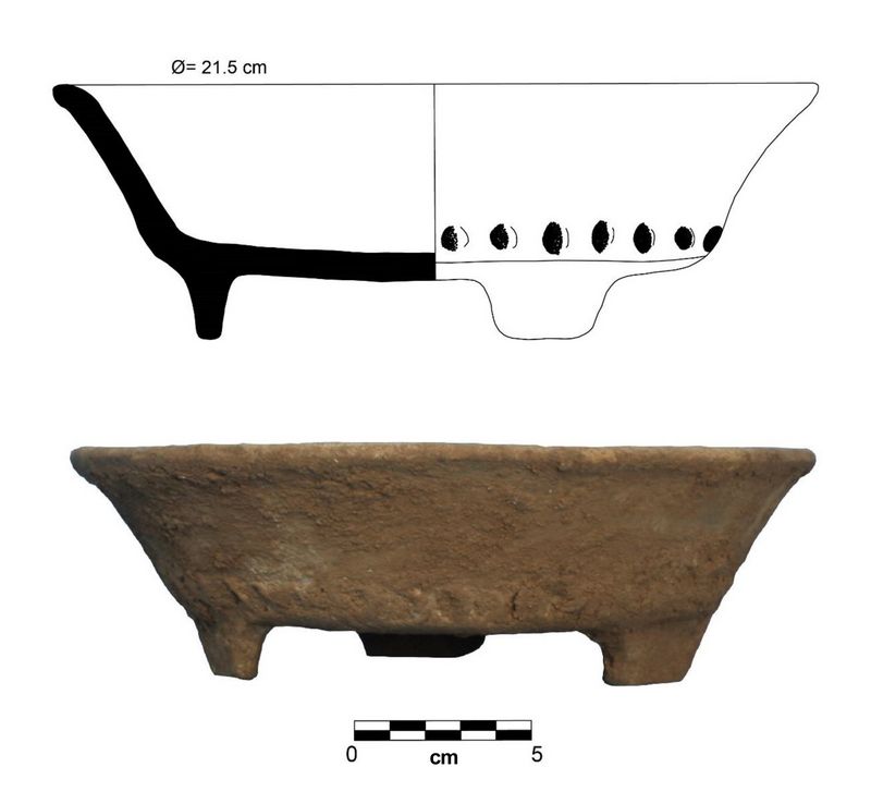
Burial 1:
Immediately to the west of the northwestern portion of Structure N2W2-1’s exterior wall, within a bedrock depression, large Yokat sherds were revealed within one 50-cm excavation unit at approximately 30 cm below the surface. These proved to be an in situ olla oriented with its opening away (to the west) from the structure that contained an upturned Sacalum plate (fig. 8). Under the plate, fill containing small, fragmentary bones was collected. The entire deposit, including both ceramic vessels, had been crushed
 by
surface activities, including the collapse of the structure’s walls.
by
surface activities, including the collapse of the structure’s walls.Analyses by Dr. Vera Tiesler, Dr. Monica Rodriguez, and Lic. Julio Chi Keb (2018) of UADY’s Laboratorio de Bioarqueologia e Historia identified approximately 20% of the skeletal remains within the fill as those of a 7-to-9-month-old fetus.. Preserved bones included cranial fragments, a clavicle fragment, foot and hand bones, pieces of ribs, and fragmentary long bones. Additionally, small fragments of faunal remains and of an adult individual were identified. Two upper, central incisor tooth fragments were included; these were critical for the fetal age estimate.
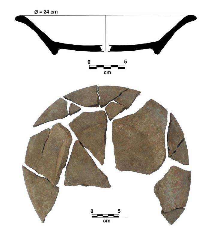
Fig.8: Tripod Bowl Muna Slate, Associated with Burial 1 of Sisal.
Burial 2:
To the northeast of Structure N2W2-1, also within a bedrock depression, was a cist containing an extended adult burial (Burial 2) with a Akil Impressed plate turned over, covering its cranium (figs. 9,10). Most of the bones were abs
 ent, although portions of the long
bones representing the arms and legs were present. While the plate was
intact, the cranium was severely crushed. A portion of one femur was found 17 cm above the
rest of the bones. The burial
was extremely shallow (with most bones being about 60cm below modern
ground level), with the bones being placed only 1-5cm above bedrock
within a natural depression that captured water like a small chaltun.
ent, although portions of the long
bones representing the arms and legs were present. While the plate was
intact, the cranium was severely crushed. A portion of one femur was found 17 cm above the
rest of the bones. The burial
was extremely shallow (with most bones being about 60cm below modern
ground level), with the bones being placed only 1-5cm above bedrock
within a natural depression that captured water like a small chaltun. Fig.9: Plan of Burial 2 at Sisal.
Analysis of Burial 2 (Tiesler, Rodriguez and Chi Keb 2018).
identified the remains of a female of approximately 15 years of age , including cranial fragments, a mandible, and some of the long bones (fig.9). The central and lateral portions of the right portion of the maxilla contained its canine, two premolars, and first and second molar. The left side of the maxilla had both incisors, canine, first premolar, and three molars. However, the absence of any hand bones or bones representing the main trunk of the body was noted.
A cranial fragment displayed evidence of porotic hyperostosis, caused by anemia associated with malnutrition or a low level of iron in the blood caused by an attempt to ward off an infectious disease. The teeth present reveal tartar build-ups
 and one
cavity, as well as enamel hypoplasia. The latter is a defect in the
enamel that occurs when teeth are still developing.
It can be the result of poor diet prenatally or as a child.
and one
cavity, as well as enamel hypoplasia. The latter is a defect in the
enamel that occurs when teeth are still developing.
It can be the result of poor diet prenatally or as a child. Fig.10: Tripod bowl Akil Impressed, Associated with Burial 2 of the site of Sisal. (Drawing by Thania Ibarra.)
A final diagnostic component is a portion of cranium revealing tabular oblique cranial deformation which is likely the result of compression using free headboards (Tiesler 2012). During Classic Maya times, such compression might indicate an elite status, so this burial may represent a young woman of elevated social status who, nonetheless, underwent prolonged nutritional stress during crucial periods of growth and development. When laid to rest, she was interred in a manner like that characteristic of Classic Maya burials.
In the southwestern corner of the excavation area, a portion of the newly discovered Structure N2W2-6 was revealed, composed of massive stones separated from bedrock by only a few centimeters of soil. Two nearly complete conch shells were discovered beneath an uncut stone, 40 cm beneath the original ground surface. The shells had been modified to make it possible to use them as musical instruments, with their ends removed and sharp points filed off.
In the northeastern end of Operation 8, meanwhile, a tubular seal was identified, resembling Black Kochol (Teresa Ceballos, pers. comm.n), which dates to the final part of the Early Classic (Varela 1998). All these data may point to the importance of this round construction within the organization of the Sisal site, although its functional nature remains to be clarified.
Ceramics:
Sisal recorded by far the largest amount of pottery recovered in 2018, with a total of 19,197 sherds recovered (76.7% of the total collection of the season), of which 13,642 sherds were identified. These include 133 sherds (0.9%) from the Middle Preclassic, 323 (2.4%) from the Late Preclassic, 2,206 (16.2%) from
 the
Early Classic, 475 (3.5%) from the Late Classic, 10,124 (74.2%) from the
Terminal Classic, and 381 (2.8%) miscellaneous sherds.
the
Early Classic, 475 (3.5%) from the Late Classic, 10,124 (74.2%) from the
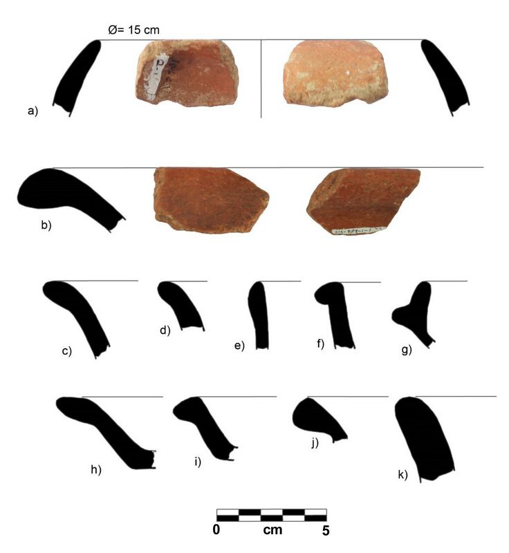
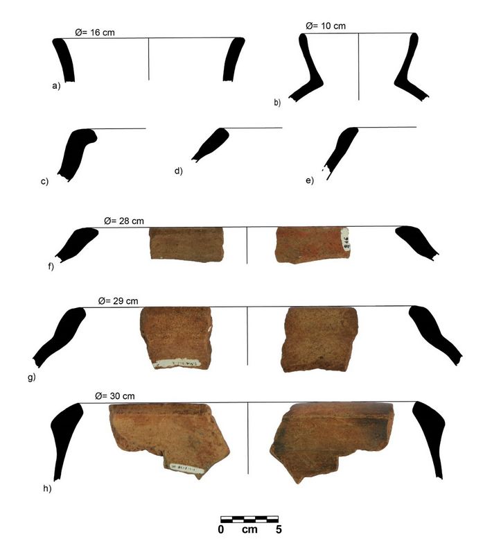
Terminal Classic, and 381 (2.8%) miscellaneous sherds.Due to a large number of materials recorded, Sisal has the greatest typological variability found in 2018.. From this it can be ascertained that during the Middle Preclassic (fig.11) the type Chancenote Striated dominates, followed in much smaller measure by Tancah, and Dzudzuquil Black-on-White and Chunhinta respectively; and during the Late Preclassic, the majority of the monochromes are Sierra, Polvero, Flor and Nolo Red.
Fig.11: Preclassic Ceramics (c. 700 B.C.- A.D. 250): a, b, d-g, i, Sierra Rojo; c, Flor crema; h, Mateo Rojo sobre Crema; j, Dzudzuquil Crema-Bayo; h, Tancah Burdo
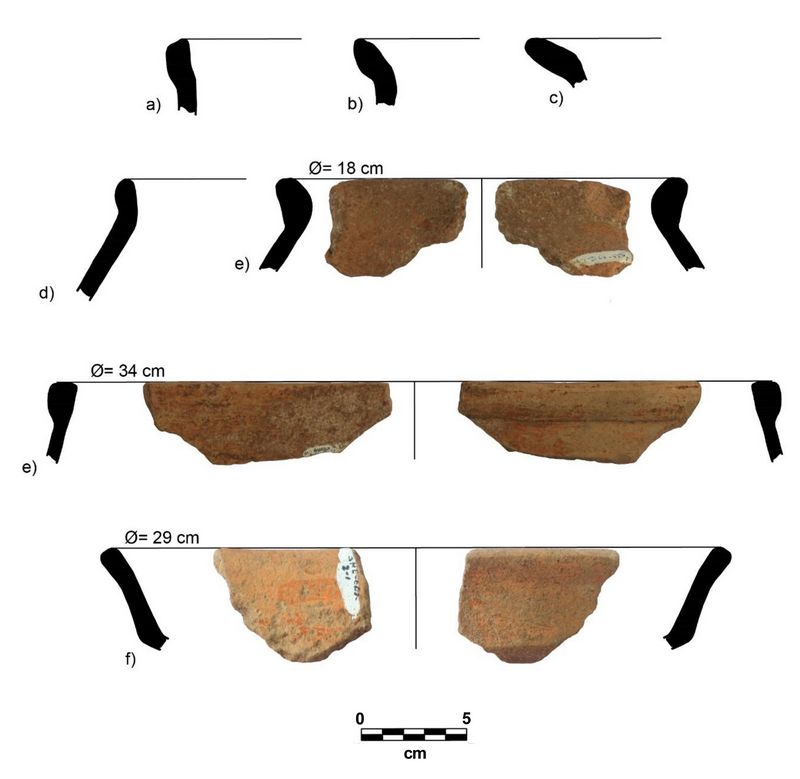
In the Early Classic Balanza, Águila and Dos Arroyos lustrous groups representing southern influence stand out (fig.12). Northern groups include Maxcanú, Tacopate and Acu; Shangurro Bichrome and Xanabá, Batres and Hunabchén Reds; coarse Yaxcabá and Triunfo; and non-designated striated wares were also widely recorded; to a lesser extent, Chencoh Thin Orange and Kanachén Black are represented.
 From
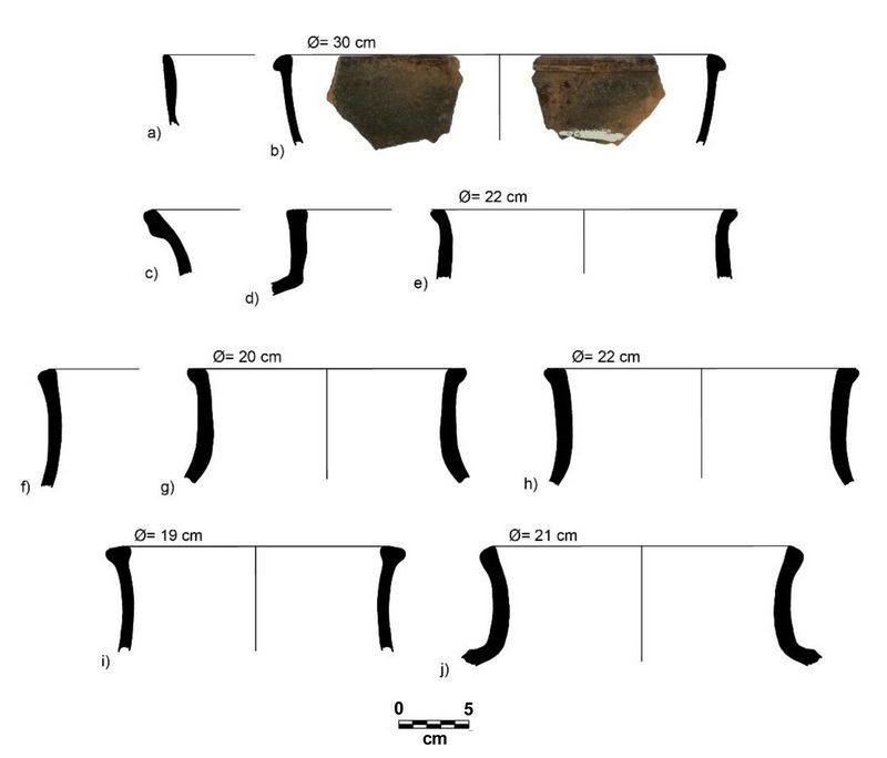
the Late Classic (figs.13+14), Katil and Encanto Striated are recorded, as is Arena
Red, Pre-slates of the Sat group, Maxcanú var. Conkal, Kinich Orange,
and Saxche Orange Polychrome. A small quantity of Dzityá Black is
recorded. The Terminal Classic is dominated by Chum, Yokat
and Vista Alegre coarse types; Muna Slate, Sacalúm, Chumayel, and
Dzitás; and to a lesser extent, Tinaja Red types, representing southern
influence. The decorated types of Tekit Incised, Akil Impressed, and
Halachó Impressed were recorded.
From
the Late Classic (figs.13+14), Katil and Encanto Striated are recorded, as is Arena
Red, Pre-slates of the Sat group, Maxcanú var. Conkal, Kinich Orange,
and Saxche Orange Polychrome. A small quantity of Dzityá Black is
recorded. The Terminal Classic is dominated by Chum, Yokat
and Vista Alegre coarse types; Muna Slate, Sacalúm, Chumayel, and
Dzitás; and to a lesser extent, Tinaja Red types, representing southern
influence. The decorated types of Tekit Incised, Akil Impressed, and
Halachó Impressed were recorded.Fig.12: Ceramics from the Early Classic period (c. A.D. 250-600): a-c, Triunfo Estriado; d, e, Grupo no Designado, Sin Engobe Estriado; e, Tacopate chorreado sobre Bayo; f, Timucuy Anaranjado Policromo.
While the ceramic record focuses on the Terminal Classic, ceramics from all periods were found (although in much smaller proportions). Therefore, it is possible that this material comes from the removal of material from older buildings. The dominance of the rough Yokat pottery and Muna slates over all other registered ceramic types is notable, including within the funerary contexts (possibly as an offering).
.
Preliminary Considerations about the Ceramic Analysis of the 2018 Season
The study emphasizes ceramics from specific contexts that do not include all time periods previously registered in the region, especially the Postclassic since these are apparently restricted to ritual uses, so they are very rare (Johnstone 2014: 382). Therefore, the absence of Postclassic ceramics in the analyzed sample does not necessarily imply a void in the occupation of the region during this period.
Fig.13: Ceramics from the Late and Terminal Classic (c. A.D. 600-1200): a-c, Maxcanú Ante; d, Chemax Prepizarra; e-h, Muna Pizarra
 On the other hand, there is an apparent void of ceramics belonging to the
Late Classic, which does not imply a depopulation of the region during
this period. This situation is common for ceramics of the Northern
Lowlands and it has tried to be overcome through the establishment of
ceramic wares prior to the slates, and an association with Katil
Striated and Conkal varieties of the Maxcanú group (Varela 1993). The
existence of early ceramics or the presence of Yokat Striated and
Kinich Orange during the Late Classic have also been postulated
(Boucher and Palomo 1995).
On the other hand, there is an apparent void of ceramics belonging to the
Late Classic, which does not imply a depopulation of the region during
this period. This situation is common for ceramics of the Northern
Lowlands and it has tried to be overcome through the establishment of
ceramic wares prior to the slates, and an association with Katil
Striated and Conkal varieties of the Maxcanú group (Varela 1993). The
existence of early ceramics or the presence of Yokat Striated and
Kinich Orange during the Late Classic have also been postulated
(Boucher and Palomo 1995).Fig.14: Ceramics from Late-Terminal Classic (c. A.D. 600-1200): a, b, Ticul Pizarra Delgada; c, Encanto Estriado; d-j, Yokat Estriado.
In the case of the study region, it is important to mention the presence, although intermittent, of polychromes with Tepeu features from the Late Classic. However, the pre-slate forms of the Sat group, Katil Striated var. Conkal, and the Kinich group are not so evident, diagnostic, or abundant, so it is unlikely that there is a context that could better define this period in the region.
On the other hand, many of these groups are not very frequent outside the western region of the Yucatan peninsula (Jiménez 2007; Jiménez Álvarez personal communication). This would imply a certain marginal position for the region, as far as ceramic developments are concerned, during the Late Classic. Although it is difficult to locate, there is a Classic ceramic presence in the region, only at present the nature of this period is unknown.
Likewise, ceramic types not previously registered in the region were recognized, such as the Nolo Rojo group (Robles 1990: 66-67, Smith 1971: 32); Tacopate Chorreado sobre Bayo (Ball 1977: 53); Timucuy Orange Polychrome (Smith 1971: 133); and Maxcanú Ante (Varela 1998). Also, less frequently identified are Caribal Red (Adams 1971: 21; Robles 1990: 68-71), Triunfo Striated (fig.12), Mudanza Chorreado on Vitreous Gray (Ball 1977: 54), Katil Striated (Varela 1993), Dzitya Black (Simmons 1980: 32-33), Maxcanú var. Conkal and Acú (Varela 1993), Tinaja Rojo (Ball 1977: 23), and Vista Alegre (Robles 1990: 179-180) from the Terminal Classic.
This situation occurs due the good preservation of the sample. Otherwise, certain types such as Maxcanu, Timucuy and Tacopate from the Early Classic are often unnoticed or confused with eroded examples of the Xanabá group due to a certain similarity in the manufacture of the paste. Regarding less frequent types, such as Caríbal, Katil, Conkal, Acú and Vista Alegre, need to be tested in future research, since in none of the cases was a reliable diagnostic marker of these types recorded (the same case applies to the above-mentioned pre-slates).
In the same way, Nolo Red and Tinaja Red are rare and poorly preserved, so they are usually associated with the Teabo Group or even the Ticul Group; analogously, the same thing happens with the Hunabchén group, which can be confused with ceramics of the Batres Group. Thus, the confirmation or correction in the establishment of these infrequent typologies is of vital importance to more accurately recognize the ceramic development after the Late Preclassic and before the Terminal Classic in the Cochuah region.
Finally, little standardization is observed in the manufacture of certain ceramics. This applies to late Preclassic red slips and Muna Slates from the Terminal Classic. In the first case, these slips are very diluted and with a matte finish, which resemble Joventud slips, so that ceramics can only be recognized by certain morphological features. Similarly in the case of slates, the pastes show a poor quality in some cases, so it is wrong to name them as slates, as they can have porosity, fragility, and an abundant presence of temper particles. Equally, they can be identified by their shape, which results in a kind of imitation of the Muna ware.
There is a persistent decoration of the chorreado on yellowish-white slips, which is classified as Tacopate (fig.12) and it seems to be linked to a very generalized tradition in the Northern Lowlands, since certain analogies are noted with the Zapatista Chorreado type from southern Campeche and Quintana Roo. This is also often confused with Caucel from the Xanabá group, characteristic of the northern portion of the peninsula.
These similarities may refer to a system of communication and interregional influence during the Early Classic period, which is clearly recorded through the presence of polychromes of the Dos Arroyos Group in the region. The identification of Maxcanú, Tituc and Timucuy Groups (fig.12) reiterates the intermediate position of the Cochuah Region, between the zones of influence coming from both the north and the south of the Yucatan peninsula during the Early Classic.
The presence of unslipped, striated ceramics is recognized as being after the Sabán group and before the Late Classic. These ceramics were classified within a non-designated group, type Unslipped Striated (fig.12), which has certain important similarities with Elote Striated from the Oxil group (Varela 1998 ) both in terms of paste and in the shape of the rim, which could refer to composite silhouette pots. However, due to the lack of evidence of corn impressions, it was decided to use this preliminary nomenclature, conserving a temporary position at the end of the Early Classic.
The Yokat and Muna forms are very common and correspond to large pots and pans (figs. 13+14), which could indicate some storage functionality. In the case of the Muna pots, the shapes of the rims are very similar to the shapes of the rims of the inverted ovoid-shaped pots and horizontal handles documented at Coba (Robles 1990: 189, 191).
Finally, certain differential characteristics are recognized in the chronological records of the excavated settlements. For example at the sites of Sacalaca Northeast Group and San Nicolás, there is a greater relative presence of the Preclassic and Early Classic periods, in tandem with a relative decrease in the representativeness of the Terminal Classic. On the other hand, the sites of Cortada and San Felipe exhibit more constant records at least until the Early Classic, with a moderate presence during the Terminal Classic. Finally, the sites of Sisal, Santa Elena, and Yodzonot (East and North) present ceramic records with an abundance of Terminal Classic ceramics and little to no representatives from the Preclassic and Early Classic periods.
All these data emphasize the particularities of the region and its internal variability, and represent aspects that must necessarily be addressed along with the frequently proposed questions for the region, such as the relationship of post-monumental architecture, ceramics, and the type of social organization during the period between the Terminal Classic and the collapse by the Postclassic.
References:
Adams, R.E.W. 1973 The Collapse of Maya Civilization: A Review of Previous Theories, in The Classic Maya Collapse, edited by T. Patrick Culbert, pp. 21-34. A School of American Research Book. University of New Mexico Press, Albuquerque.
___ 1991 Nucleation of Population and Water Storage Among the Ancient Maya. Science 251(4994):632.
Aveni, Anthony 2001 Skywatchers: A Revised and Updated Version of Skywatchers of Ancient Mexico. University of Texas Press, Austin.
Badillo Sanchez, Alejandra 2010 “Un espacio dos lugares: de mayas y militares; el paisaje construido en el noreste de la región de Yo'okop” in Reporte final de la Temporada de campo 2010 del Proyecto de Reconocimiento Arqueológico de la Región de Cochuah, edited by Justine M. Shaw, pp. 13-47. College of the Redwoods, Eureka, CA.
_____ 2012 “Historias que convergen a través de los objetos: Fortín de Yo'okop”, Operaciones 1 y 2 in Reporte final de la Temporada de campo 2012 del Proyecto de Reconocimiento Arqueológico de la Región de Cochuah, edited by Justine M. Shaw, pp. 24-59. College of the Redwoods, Eureka, CA.
______2018 Rumbo al corazón de la tierra macehual. La Campaña Militar de Yucatán contra los mayas 1899-1904. Tesis para obtener el grado de Doctor en Historia. Mérida, Yucatán, México: CIESAS Peninsular (en redacción).
Dahlin, Bruce 2009 Ahead of Its Time?: The Remarkable Early Classic Maya Economy of Chunchucmil. Journal of Social Archaeology 9(3):341-367.
Flores Alberto G. 2004 “Mulob y Pozos: Relaciones entre Asentamientos Prehispánicos y Coloniales” in Reporte final de la Temporada de campo 2004 del Proyecto de Reconocimiento Arqueológico de la Región de Cochuah, edited by Justine M. Shaw, pp. 195-208. College of the Redwoods, Eureka, CA.
Flores Colin, Alberto G. and Alejandra Badillo Sanchez 2014 “El mapeo del sitio Puesto de la Aguada (Puesto Militar número 8)”, in Reporte final del Proyecto de Reconocimiento Arqueológico de la Región de Cochuah, Temporada 2014, edited by Justine M. Shaw, pp. 224-232. College of the Redwoods, Eureka, CA. 729
Flores, Colin Alberto G., Justine M. Shaw, and Karleen Ronsario 2015 “Operación 10, Estructura N4E4-3 de San Felipe”, in Reporte Anual del Proyecto de Reconocimiento Arqueológico de la Región de Cochuah, Temporada 2014, edited by Justine M. Shaw, pp. 311-346. College of the Redwoods, Eureka, California.
General de División Ignacio A. Bravo y General de Brigada José María de la Vega
1903 Relación que manifiesta las construcciones hechas por cuenta del Gobierno Federal en todos los puntos es esta Zona ocupados por fuerzas del mismo así como las que se hallan en obra y herramientas que existen, Campamento General Vega, Diciembre 12 de 1903 (AH-SEDENA Expediente XI/481.4/14738, Quintana Roo 1903, f.1-18).
Harrison-Buck, Eleanor 2012 Architecture as Animate Landscape: Circular Shrines in the Ancient Maya Lowlands. American Anthropologist 114(1):64-80.
Johnstone, Dave P. 2016 The Dating and Function of Circular Structures, in Annual Report of the Cochuah Regional Archaeological Survey’s 2014 Field Season, edited by Justine M. Shaw, pp. 538-543. College of the Redwoods, Eureka, CA.
Kaeding, Adam 2005 “Xbalche”. Capítulo 21 in Reporte final de la Temporada de campo 2005 del Proyecto de Reconocimiento Arqueológico de la Región de Cochuah, edited by Justine M. Shaw, pp. 138-152. College of the Redwoods, Eureka, CA.
Killion, Thomas 1992 Gardens of Prehistory: The Archaeology of Settlement Agriculture in Greater Mesoamerica. University of Alabama Press, Tuscaloosa, AL.
Killion, Thomas W., Jeremy A. Sabloff, Gair Tourtellot, and Nicholas P. Dunning
1989 Intensive Surface Collection of Residential Clusters at Terminal Classic Sayil, Yucatan, Mexico. Journal of Field Archaeology 16(3): 273–294.
Lloyd, Christopher 2005 “Operación 1 de San Felipe”, in Reporte Final del Proyecto de Reconocimiento Arqueológico de la Región de Cochuah, Temporada 2005, edited by Justine M. Shaw, pp. 163–170, College of the Redwoods, Eureka, California.
Lucero, Lisa J. 2003 The Politics of Ritual: The Emergence of Classic Maya Rulers. Current Anthropology 44(4): 523-558. 730
Martos, Luis Alberto y Rodríguez A. Sánchez, Ernesto 1998 Informe de la temporada 1998 del proyecto de arqueología histórica Fortín de Yokob, Quintana Roo. Arqlgo. Instituto Nacional de Antropología e Historia, D.I.C.P.A. y D.S.A.
Mason, Gregory 1926 Explorers Start for Maya Jungle. New York Times, March 7, 27.
Morley, Sylvanus G. 1946 The Ancient Maya. Stanford University Press, Stanford.
Redfield, Robert 1953 The Primitive World and Its Transformations. Cornell Univ. Press, Ithaca, N.Y.
Reyes, Bernardo 1902 “Memoria de la Secretaría de Estado y del Despacho de Guerra y Marina” Presentada al Congreso de la Unión por El Secretario del Ramo Gral. de División Bernardo Reyes. Comprende del 1 de Enero de 1900 al 30 de Junio de 1901 (Archivo Histórico-SEDENA).
Roys, Ralph L. 1965 Ritual of the Bacabs. Civilization of the American Indian Series. University of Oklahoma Press, Norman.
Sabloff, Jeremy A. 1973 Major Themes in the Past Hypotheses of the Maya Collapse, in The Classic Maya Collapse, edited by T. Patrick Culbert, pp. 35-40. A School of American Research Book. University of New Mexico Press, Albuquerque.
____ 1992 Interpreting the Collapse of Classic Maya Civilization: A Case Study of Changing Archaeological Perspectives, In Meta-Archaeology: Reflections by Archaeologists and Philosophers, edited by Lester Embree, pp. 99-119. Kluwer Academic Publisher Dordrecht, the Netherlands.
Shaw, Justine 2015 (editor and contributor) The Maya of the Cochuah Region: Archaeological and Ethnographic Perspectives on the Northern Lowlands. University of New Mexico Press, Albuquerque.
____ 2003 “Ejido de Sacalaca,” in Reporte Final del Reconocimiento Arqueológico de la Región de Cochuah, edited by Justine M. Shaw, pp.139. College of the Redwoods, Eureka, CA. 731
Shaw Justine M. and Alberto G. Flores 2010 “El Sitio de Yo'dzonot, Sacalaca”, in Reporte final del Proyecto Arqueológico de la Región de Cochuah. Temporada de campo 2010, edited by Justine M. Shaw, pp. 363. College of the Redwoods, Eureka, CA.
____ 2008 “San Felipe”, in Reporte Final del Proyecto Reconocimiento Arqueológico de la Región de Cochuah, Temporada 2008, edited by Justine M. Shaw, pp. 181–187, College of the Redwoods, Eureka, California.
Smith, R. E., Willey, G. R., and Gifford, J. C. 1960 The Type-Variety Concept as a Basis for the Analysis of Maya Pottery. American Antiquity 25(3), 330–340.
Smyth, Michael P. 1991 Modern Maya Storage Behavior: Ethnoarchaeological Case Examples from the Puuc Region of Yucatan. University of Pittsburgh, Pittsburgh, PA.
Smyth, Michael P., Christopher D. Dore, and Nicholas P. Dunning 1995 Interpreting Prehistoric Settlement Patterns: Lessons from the Maya Center of Sayil, Yucatan. Journal of Field Archaeology 22(3): 321–347.
Storey, Rebecca and Glenn R. Storey 2017 Rome and the Classic Maya: Comparing the Slow Collapse of Civilizations. Routledge, New York.
Strömsvik, G., H. E. D. Pollock, and H. Berlin. 1955 “Exploration in Quintana Roo.” In Carnegie Institution of Washington Year Book No. 53, July 1, 1953-June 30, 1954. Washington, DC.
Wren, Linnea and Travis Nygard 2015 The State of Research in the Cochuah Region of Quintana Roo. In The Maya of the Cochuah Region: Archaeological and Ethnographic Perspectives on the Northern Lowlands, edited by Justine M. Shaw, pp. 25-40. University of New Mexico Press, Albuquerque.
Young,Tatiana 2005 “Mapeo y excavaciones en Parcela Escolar”, in Reporte final de la Temporada de campo 2005 del Proyecto de Reconocimiento Arqueológico de la Región de Cochuah, edited by Justine M. Shaw, pp. 124-133. College of the Redwoods, Eureka, CA.
Recent Foundation grants: general Archaeology Grants Program w/map
Copyright © 2022 Rust Family Foundation