Rust Family Foundation: Archaeology Grants Program
Romanisation of Umbria Project [Umbria, Italy]
Principal Investigator: Simon Stoddart
Professor, University of Cambridge
Introduction (Simon Stoddart and Letizia Ceccarelli)
The project employed several methods to study how the Roman empire incorporated the powerful Etruscan state of Perugia in Umbria into its political and economic structure (fig.1). These methods included: a) excavation of two Roman pottery kilns at Montelebate, and kiln replication (directed by Letizia Ceccarelli of the University of Cambridge); b) an archaeological survey of the upper Tiber valley (directed by Simon Stoddart); and c) a geoarchaeology study of the area around Montelebate (directed by Sean Taylor of the University of Cambridge).
The expansion of empires (e.g. Alcock et al. 2001), the enlargement of political states, is a live question today, as superpowers engage in strategies of political supremacy, both between themselves and in competition with neighbouring states. They deploy facts (and non-facts) rhetorically and perhaps less
 rhetorically. The material world tells a
different story and this is what archaeology is good at dissecting, in
both the modern and ancient world. We will set the rhetorical texts
against the economic facts in an important region of early expansion of
the Roman world.
rhetorically. The material world tells a
different story and this is what archaeology is good at dissecting, in
both the modern and ancient world. We will set the rhetorical texts
against the economic facts in an important region of early expansion of
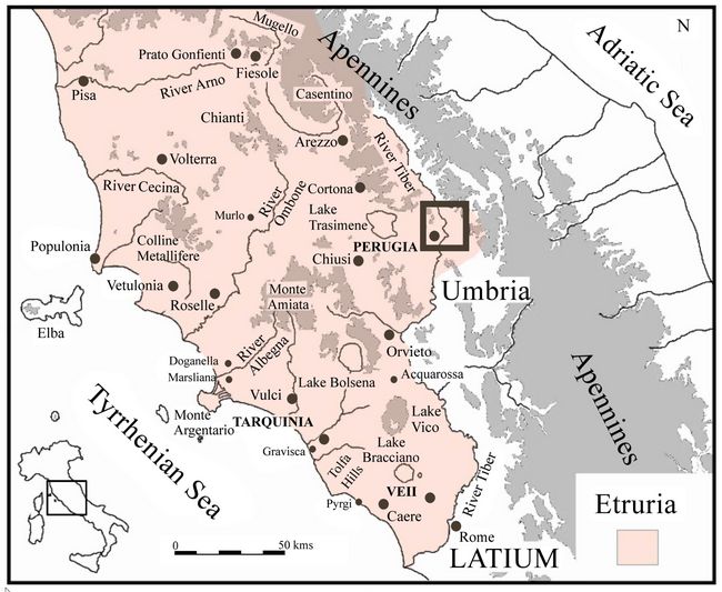
the Roman world.Fig.1: Location of Study Area (black box), Veii and Rome.
In the fourth century BC, after the famous siege of Veii by the Romans in southern Etruria, the Romans began to move into the ascendant against their northern neighbours, the Etruscans. The contact with Perugia, the most easterly of the northern Etruscan cities was a process of the third century BC and this second phase was the focus of our current research.
The political engagement with Perugia has always been studied from an urban (Cenciaioli 2014; Bratti 2007; Calzoni & Pierotti 1950-1) and textual perspective. We have a number of written sources which give a phased account of the rival political masters, their treaties and their wars (Harris 1971; Sisani 2007). We have detailed insights from their tombs not only about changing perceptions of death (Nati 2008), but also about the move from Etruscan to Latin as the language of the élite (Cenciaioli 2011). This is a story told by the rulers not by their subjects.
The current project asked key questions about what sustained this change by looking into the countryside north of Perugia, where we have uncovered three distinct phases.
• An Etruscan phase centred on the rural site of Col di Marzo starting in the late fifth century BC and ending c. 270/260 BC.
• A phase of apparent abandonment of the countryside, following closely the military campaigns in the area in the mid-third and second centuries BC.
• A re-occupation of the landscape in the first century BC, accompanied by a new political economy.
We now have a detailed picture of how this landscape worked as a result of the season’s work. We have successfully asked how this political process affected the less privileged rural population and how the new economy was organised. We have established the density and distribution of farmsteads in the new countryside. We have investigated to what extent local production of wine, oil and building materials fed into the larger scale economy of ancient Rome. We have made a preliminary investigation of how the opening up of this upland landscape inadvertently had a detrimental effect downstream on the river regime of Ancient Rome.
Project Goals:
1. Completion of the excavation of a well preserved Roman kiln which provides unparalleled evidence of a key feature of the underlying economy. A replica of this kiln was also constructed to conduct experimental analysis on the technology of production.
2. The continued field survey on both banks of the Tiber to establish the density and spatial distribution of rural settlement was highly successful.
3. A preliminary geoarcheological assessment of the historical phases of erosion and deposition in the Ventia valley, a
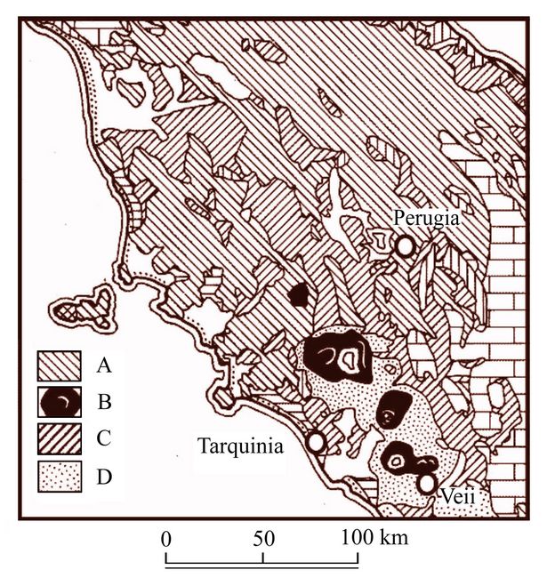 tributary of the Tiber (cf. fig.2).
A fourth goal originally planned for the project, the excavation of a Roman farmstead for bones, seeds, and artefacts, was left for future work, since it was decided to concentrate on the three principal aims with the resources available. The detailed survey of the left bank of the Tiber, including the discovery a Roman villa (with mosaics and wall plaster) and a large Roman agricultural complex more than compensated in terms of understanding the Roman economy.
Fig.2: Geological context of central Italy. A sandstones. B Volcanic cones. C Pliocene basins. D Tuff plains.
Results of Funded Project (RFF-2018-66):
..
Kiln excavation (Letizia Ceccarelli)
A successful excavation campaign was conducted between the 30th of July and the 30th of August 2018, as part of the Montelabate Project, focused on two of the six Roman kilns identified between 2012 and 2017 near the Abbey of Montelabate in Perugia. This discovery offers important new insights into the technology of production and circulation of ceramics in Regio VI (Umbria) for over five centuries. On the basis of the chronology of the ceramics produced at the site, especially the amphorae, the kilns were in use at least from the late first century BC to the late fourth and the fifth century AD (Ceccarelli 2017).
The production area on the top of a hill at 340 m above sea level was located on a rich clay deposit. River connectivity was provided by the Ventia, a tributary of the Tiber 5 km away and the densely forested hills surrounding the site (Umbria was rich in forests as mentioned by Cicero, De divinatione 1.94) delivered the necessary fuel. The site was thus ideally located to support ceramic production.
The most important discovery of this pottery workshop was the spatial distribution of the kilns and other manufacturing facilities, which were constructed around a substantial clay bed; this was extensively sampled and analysed from a geoarchaeological perspective (see below) and characterised chemically and physically by the Department of Chemistry, Materials and Chemical Engineering of the Politecnico of Milan.
The study of the kiln complex at Montelabate has begun to demonstrate how the local economy was interconnected to the macro-economy of the Roman world. Specialised flat bottomed amphorae, known as Spello-type, Ostia III, 369-70 / II, 521 or Altotiberine were generally produced from the Tiberian–Claudian period until the end of the second century AD and perhaps also in the early third century AD. Their specific shape was designed to ship local wines down river to the growing population of Rome (Ceccarelli 2017). The shape of these small wine containers was ideal for medium-range overland and, in particular, river transport. Moreover, the morphology met short-term needs of wine consumption without the need for decanting; these amphorae were thus the final container of the product, whose preferential markets appear to have been Rome and Ostia.
 Once
other containers (perhaps wooden barrels) took hold, other material
such as bricks, tiles and cooking ware became the focus of production
and seem also to have been shipped towards the heart of the Roman
empire. The low hills of Umbria bordering the upper Tiber were ideally
suited to this economic purpose within the broader Roman empire. The
availability of plentiful supplies of wood, clays, limestone temper,
water and a mild climate combined to produce the resources for both the
ceramic containers and the climate for vines and olives.
Once
other containers (perhaps wooden barrels) took hold, other material
such as bricks, tiles and cooking ware became the focus of production
and seem also to have been shipped towards the heart of the Roman
empire. The low hills of Umbria bordering the upper Tiber were ideally
suited to this economic purpose within the broader Roman empire. The
availability of plentiful supplies of wood, clays, limestone temper,
water and a mild climate combined to produce the resources for both the
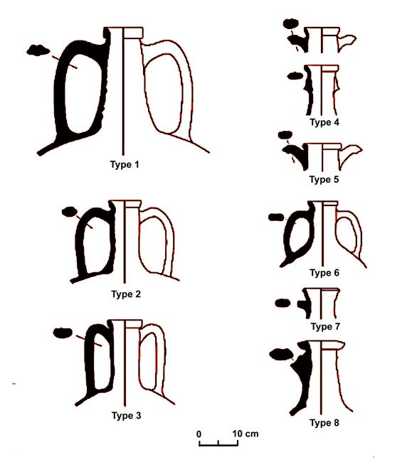
ceramic containers and the climate for vines and olives.Fig.3: Amphorae types produced in the kiln complex.
The 2018 season focussed on the excavation of two kilns. Constructed at right angles to each other, the kilns (1 and 6) were designed to be operated concurrently. Kiln 1 was orientated North-South, perhaps to create a favourable updraft during the firing process, and Kiln 6 was orientated East-West.
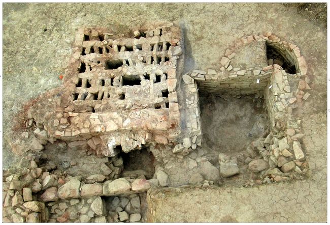
Fig.4: Kiln 6, with the perforated platform still in situ at the end of the excavation.
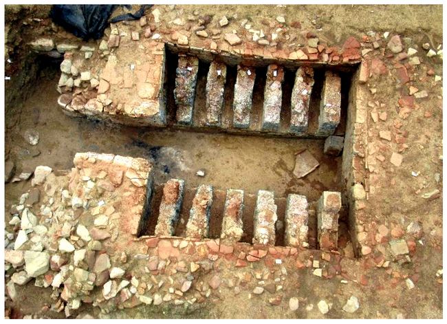
Kiln 6 (figs.4-5) has now been fully excavated and recorded following its definition by an earlier gradiometry and subsequent georadar survey. The excavation revealed a very well-preserved structure (2.3m x 3m x1.5m) with an in-
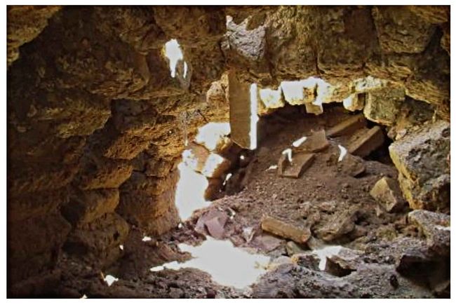 tact combustion
chamber comprising five arches of refractory bricks, each 28cm in
width, supporting a perforated floor which separated it from the firing
chamber where vases were placed to be fired. To the south of the kiln,
a rectangular structure was also excavated, whose function can be
closely associated with pottery production, possibly as a storage
facility to dry vessels before firing.
tact combustion
chamber comprising five arches of refractory bricks, each 28cm in
width, supporting a perforated floor which separated it from the firing
chamber where vases were placed to be fired. To the south of the kiln,
a rectangular structure was also excavated, whose function can be
closely associated with pottery production, possibly as a storage
facility to dry vessels before firing.Fig.5: Standing arches made of refractory bricks inside the combustion chamber of kiln 6.
Kiln 1, identified in the 2012 season, was fully excavated revealing a substantial structure of 4.20m in length and 3.10m in width (fig.6). The combustion chamber consisted of external walls built with fired bricks and mortar, whilst the construction of the arches supporting the perforated floor and firing chambers made extensive use of mud-bricks. The stocking-hole (or praefurnium) of the kiln was also preserved; it was constructed using low brick walls covered by a brick
 arch that led
to the combustion chamber where the fuel was placed. Outside the kiln,
there were several associated work surfaces made of flat limestone
blocks.
arch that led
to the combustion chamber where the fuel was placed. Outside the kiln,
there were several associated work surfaces made of flat limestone
blocks.Fig.6: Kiln 1 at the end of the 2018 excavation campaign.
.
3. Kiln reconstruction (Letizia Ceccarelli)
An experimental, functional Roman kiln was constructed (fig.7), measuring 1.5m x 1.5m with a double chamber (height of 2.40 m) where three internal arches supported a perforated floor. Built at a scale of 1:2, the kiln was based on the plan of Kiln 6 (see above) and was constructed using locally sourced materials. The aim of the project was also to demonstrate ancient firing technology to the general public.
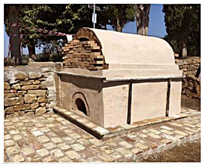
The kiln required 5 tons of purpose hand-made refractory bricks, following a design that also incorporated temperature monitoring techniques. The walls have a thickness of 4.7 inches (12 cm) which provide strength to the structure as well as the prevention of thermal shock and insulation, necessary as the internal temperature rises above 800°C.
.
Fig.7: The final reconstruction of the working Roman kiln.
Initial tests revealed the structure was able to withstand expansion from the heating of continuous fire for over 12 hours and the contraction after the cooling phase. The first successful experiments were conducted with the reproduction of Roman bricks using locally sourced clay.
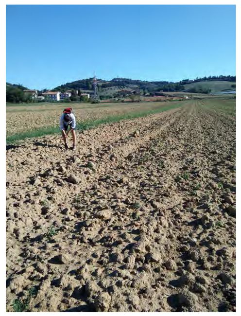
The Upper Tiber valley survey (Simon Stoddart)
Field survey was conducted for nearly four weeks between 17 September and the 11th October (fig.8). Most of the work was conducted on the left (eastern) bank of the Tiber, since the right (western bank) proved to be heavily urbanised (or enclosed), eroded, wooded or otherwise inaccessible.
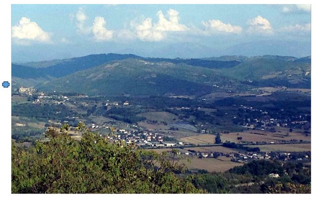
Fig.8: View from Monte Civitelle east back over Tiber and Montelabate transect. Civita Benazzone is indicated by the blue cross.
Work on the right bank was restricted to the study of the Monte Vile ridge where thanks to the collaboration of the landowners a reasonable coverage was achieved. Consequently, in this area, only one Roman farmstead with Spello amphorae was discovered. Visits were also made on the right bank to two Etruscan period fortified enclosures at Mont
 e
Civitelle and Monte Elceto di Murlo (fig.9).
e
Civitelle and Monte Elceto di Murlo (fig.9).The visits to the fortified sites of Civitelle and Elceto di Murlo confirmed the model of Etruscan settlement. In the Etruscan period, smaller rural settlement was absent until the very late period (c. 270 BC). The only earlier occupation seems to have been small nucleated, upland villages of different forms that include the enclosures of Civitelle and Elceto di Murlo on the right bank and Civitelle d’Arna, Civitella Benazzone and Col di Marzo on the left bank of the Tiber.
Fig.9: Drystone enclosure on Monte Civitelle on right bank of Tiber.
For the Roman period, the survey was remarkably successful in defining both the empirical evidence and a model of economic organisation for the
 left bank of the Tiber. The 2018
work significantly took the survey transect down to the river Tiber
from the catchment of the Ventia tributary, as well as filling in
available areas on the Gaslini estate. Our work was also substantially
helped by the skilled observation of Corrado Cesarini, who had worked
many of the surrounding fields.
left bank of the Tiber. The 2018
work significantly took the survey transect down to the river Tiber
from the catchment of the Ventia tributary, as well as filling in
available areas on the Gaslini estate. Our work was also substantially
helped by the skilled observation of Corrado Cesarini, who had worked
many of the surrounding fields.Fig.10: View from Roman villa site west towards the Tiber and the hills beyond on the right bank.
When the results of the 2010 survey (largely above 300 m asl) are combined with the results of the 2018 survey (mainly between 200 and 300 m asl), the data set now comprises tw
 enty Roman farmsteads, one kiln production centre, one
small villa (figs. 10,11; defined by good view; good
communications; fine ware, amphorae mosaics, marble and wall plaster)
and one larger agricultural centre (whose cemetery has been excavated
by the local archaeological authorities).
enty Roman farmsteads, one kiln production centre, one
small villa (figs. 10,11; defined by good view; good
communications; fine ware, amphorae mosaics, marble and wall plaster)
and one larger agricultural centre (whose cemetery has been excavated
by the local archaeological authorities).Fig.11: Substantial concrete platform in centre of villa (5 m scale).
The data form an interesting distribution (Fig.12). The twenty farmsteads are all below 0.6 ha (1.5 acres) in size and range across the landscape from the base level of the Tiber at about 200 metres (656 feet) above sea level (asl) to the upper levels of surveyable land at 350 metres (1150 feet) asl). Many of these sites were in close proximity to the Ventia stream which connected with the Tiber, that ran through the survey area from 250 m asl to 230 m asl. The two larger sites were closer to the Tiber at just below 250 metres (820 feet) asl.
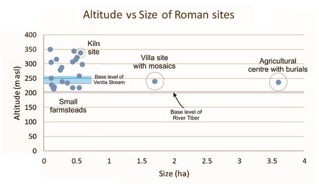
Fig.12: Distribution of Roman sites by size and altitude.
We have tentatively reconstructed this pattern as a working economic model for the Roman period (Fig.13). The landscape broadly drops in height from east (from the right) to west (to the left) along the 6.5 km long transect from the hills by the medieval abbey down to the Tiber. We suggest that the managers of the kiln site distributed amphorae in the upper part of the landscape, which were then sent down the Ventia to the Tiber. We furthermore suggest that the large agricultural centre coordinated the lower part of the landscape with easy access to the Tiber for distribution to Rome. The Roman villa site (and the remaining farmsteads) are located just outside the principal transect. This working model will be further explored with more sophisticated GIS based techniques.
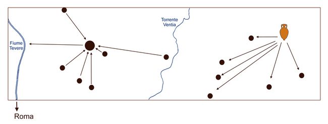
Fig.13: Model of Roman economic organisation based on the principal (6.5 km long) transect. All these sites had Spello type amphorae.
Geoarchaeology Report for Montelabate (Sean Taylor)
Introduction
This report communicates the observations and results of the geoarchaeological survey carried out by the author at the beginning of October 2018. The survey had three definite aims as its objectives. The first and most important was to establish if there had been patterns of erosion and deposition, particularly any linked to the Roman period. It is at this time that we have the best archaeological evidence. This is an important issue because it links in to processes which are happening further down the Tiber (Aldrete, 2007). Textual sources indicate that in Rome they had to respond to flooding by constructing defences.
Confirming that the expansion of settlement in the Roman period was linked to erosion would therefore be an important finding. The hypothesis is that increased runoff due to the expansion of arable land had a positive correlation with this flooding. It would be also important to examine evidence for sediment deposition at the mouth of the Tiber during this period to connect this with landscape changes seen higher in the catchment. These changes involve the drastic opening of the landscape in the late Republican and early Imperial periods during the first century AD. This evidence suggests that there are more rural settlements during this period, and that one might therefore expect the cutting down of trees.
Developing wine and olive production might also lead to runoff and associated geomorphological changes. Demonstration of episodes of erosion in that period would thus be an important finding. Supplementary to and connected to that, if we can identify palaeosoils and land surfaces associated with this period we can better understand landscape development during this period. In addition, it would be important to establish if there had been any erosion occuring before the Roman period, though this will of course be more of a challenge to date.
The second issue is linked to the Roman kiln recently excavated in the village of Montelabate. It was thought important to know where the clay used for the manufacture of the pottery had been obtained from. The hypothesis was that it was local but this required testing by means of soil survey.
A third objective was to establish if there are any environmental
deposits such as palaeochannels which might preserve pollen and other important data through the maintenance of anaerobic conditions.
Methods
The primary method was soil survey (Dekker and De Weerd, 1973). This characterises the spatial distribution of soil types across a 14km2 transect across the catena. The survey aimed to produce a generalised understanding of Montelabate based on the spatial distribution of soil profile data. The soil profiles are selected in order to characterise the range and distribution of soil types across the landscape. The soil survey that was carried out at Montelabate sampled soil profiles along various slopes from the Village to the Tiber. The rationale behind this is that soils along a slope share a genetic relationship that is related to the topography, geomorphological history and the hydrological conditions along that slope (Birkeland, 1984). They tend to vary in a predictable way along the slope, forming what is known as a catena (Milne, 1935). Soil profiles are observed by using an auger and/or road cuttings and also natural cliffs and banks. The properties of the soil are recorded in a soil profile database (Roşca et al., 2013). These include number, designation, depth and colour of horizons, and their texture and structure (Avery, 1973). The author was keen to look at the archaeological survey in order to make an initial judgement on suitable places to sample.
Results
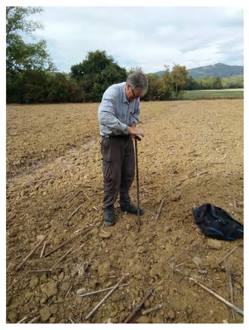
One of the objectives of the soil survey in the vicinity of the village of Montelabate was to find the source of clay used to make the pottery that was found associated with the recently excavated kiln. The hypothesis was that the clay came from relatively near. Two auger profiles were sampled within 100 m of the kiln Here we identified Calcic Luvisols (W.R.B., 2014), with a clay component of at least 25% (fig.14). Both profiles had an argic horizon (illuvial clay) (McKeague, 1983) with a texture of clay loam with at least 20% fine sand which would have been a good temper for pot production.
Fig.14: Augering the Luvisols associated with an archaeological site identified in 2010 (photo: Sean Taylor).
The soils had formed from marine sediments as parent material, and so there was a high proportion of calcium carbonate. This property would have improved the firing of the pottery. In conclusion, the very local soil would have provided the clay necessary for pottery production at the site and it is likely that wood was procured locally.
Due south of the village, a very deeply incised channel cut into the relatively soft limestone. There was a significant flow of water suggesting that this is a perennial stream. Clearly during the late winter and spring with maximum water volume the stream has great erosive power. As this is a tributary of the Tiber, during these times the sediment load is likely to be flushed out the system completely, or at least sediment is likely to be channeled futher down the catchment. Very steep valley sides with hard wood cover are also present. Rills in some of the ploughed fields clearly indicate that, today, material is being eroded particularly on the steeper slopes.
A road cutting across one of the valley slopes in the environs of Montelabate gave an excellent longitudinal section through the soils. The soils of the slope tend to have ephemeral A horizons. They have a sandy texture, so they tend not to retain an obvious organic-rich topsoil. In addition, the climate tends to mitigate against the accumulation of organic material. These soils are high
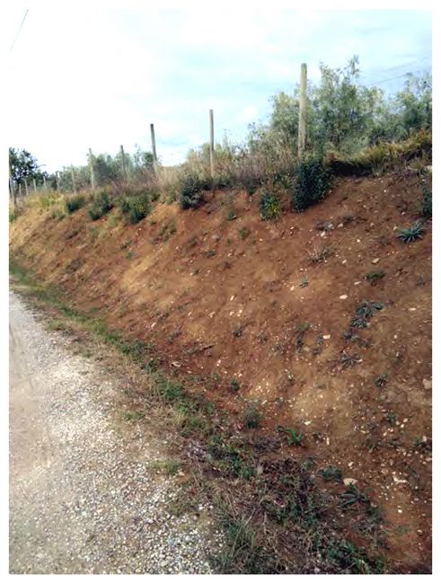 in
carbonates.
in
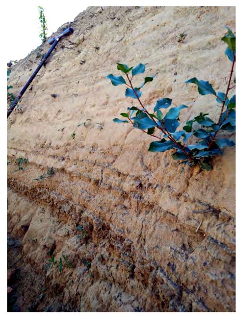
carbonates. The section is a colluvial deposit as there is abundant archaeological material in the soil profile consisting mainly of maily terracotta sherds. Some of it has the appearence of prehistoric material. The older assemblage is certainly deeper in the soil profile, at around 3m below the surface, suggesting a period of early erosion. This pottery has distinctive temper, large quartz clasts and shells. This is significant information as it indicates that the soils on the slope have been highly dynamic in the past (fig.15).
Fig.15: Colluvial deposit with associated buried archaeological material (photo: Sean Taylor).
This section revealed structural changes such as cracking in the subsurface horizons below an ephemeral presumed A horizon, and good evidence of movement of soil. It also shows us that archaeological material at 3-5 degrees of slope are highly likely to be moved (Evans and Nortcliff, 1978). Older material is also likely to be buried quite deeply (Holliday, 1985).
A shallow gradient promontary further down the valley revealed abundant archaeological material at the surface, including building material, tiles, masonry and bricks. Clearly, in this part of the slope with near-zero gradient, one would expect very little movement of sediment. At these points in the landscape there is good archaeological visibility on the surface. Increased gradient is likely to move archaeological material down the slope and also bury sites.
Further down the valley, there were hard carbonate bedrock exposures. These are Leptosols, exceedingly thin, poorly developed soils indicating that soil is being quickly removed from the ground surface. Water is being funneled through, with overland flow and removal of soil, thus keeping soil formation youthful. Fields further along the catena were characterised by a 5 degree slope.
Below these is a very deep cut associated with a tributary stream of the Tiber. Most of the soils here are sandy silt loams and clay loams. Prior to erosion they would have been lighter in terms of texture in the upper parts of the profile before the onset of eroson. The subsoils have more clay in them but they have probably 20% clay at least 25% sand and 50-60% silt. The stream had a very deeply incised channel with a great deal of colluvial fill of at least 6m.
Within many of the ploughed field with gradients above 6 degrees were discrete areas characterised by very stoney light greyish soils. It is quite clear that the combination of rapid erosion and mechanised deep ploughing have exposed regolith and weathered bedrock. This suggests that whatever soil material that was here has become part of colluvial downward movement of sediment.
To the north of a modern stream channel and west of a tomato and fruit farm is a very large palaeochannel (fig.16). Clearly there is a huge levee composed of large cobbles and boulders indicating that this channel experienced significant energy in its flow. Several auger samples taken in
 this location revealed a sequence of Fluvisolic soils. These
have formed on significant depths of sediment which fill this former
channel. So far, this the best place identified in the survey for further investigation of
environmental proxy data. The
channel fill is a fine sandy silt loam. The modern agriculture has
exploited this geomorphological feature. It clearly retains moisture
and nutrients which add significant value to agricultural
production The soils associated with the channel so far lack any
archaeological evidence.
this location revealed a sequence of Fluvisolic soils. These
have formed on significant depths of sediment which fill this former
channel. So far, this the best place identified in the survey for further investigation of
environmental proxy data. The
channel fill is a fine sandy silt loam. The modern agriculture has
exploited this geomorphological feature. It clearly retains moisture
and nutrients which add significant value to agricultural
production The soils associated with the channel so far lack any
archaeological evidence.Fig.16: Augering the palaeochannel. Note the massive levees characterised by large boulders and cobbles (photo: Sean Taylor).
Near the river Tiber were various longitudinal ditches excavated to drain agricultural fields. One particular ditch had large fragments of terracotta storage vessel presumably in situ. The soils in this part of the landscape are Colluvic Regosols. The sections are very interesting. The ditch is approximately 80cm deep, clearly consisting of colluvial soil material coming from higher on the slope through erosion processes. There is multi-period artefactual evidence in the matrix of the colluvium. A worked chert flake was observed eroding at 50cm, showing that erosional processes have lead to the homogenisation of sediments. A distal end of a cattle femur was observed
 indicating that
the soil to be calcareous. In the section there is abundant artefactual
material, mainly well worn and rounded pottery, one component of this
colluvial mass movement down the slope. This suggests that
archaeological sites are going to be relatively deeply buried.
indicating that
the soil to be calcareous. In the section there is abundant artefactual
material, mainly well worn and rounded pottery, one component of this
colluvial mass movement down the slope. This suggests that
archaeological sites are going to be relatively deeply buried.Further towards the river the ditches have a different character. The parent material for the soils here and in the vast majority of the floodplain is clearly fluvial material. There are horizontally orientated bands alternating between coarse sands and silts (fig.17).
Fig.17: Fluvial sediments seen in the section of ditches of the floodplain (photo: Sean Taylor).
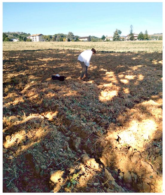
Auger samples showed the layers to be similarly varied but all horizontally orientated. There is a distinct probablity that several former channels exist in this part of the landscape, but this hypothesis must be adressed with future fieldwork. Beyond the main autostrada is a large sandy alluvial floodplain. Based on the significant amount of lithics, it appears to be a very ancient and stable part of the landscape (Fig.18). Soils of this part of the landscape appears to be relict palaeosols. In one of the nearby ditches were found 50cm chert artefacts eroding out of the matrix.
Fig.18: The area of relict palaeosols associated with dense concentrations of lithics (photo: Sean Taylor).
Conclusion
It is now clear that there has been a great deal of geomorphological change in the study area. Abundant evidence has presented itself suggesting that there has been severe soil erosion in the catchment. Several sections show that much of this is in the form of colluvium. This information is important because it is relevant to the interpretation of survey data. Surface finds will have been moved from their primary context and potential in situ archaeological sites are likely to be buried, some possibly quite deeply.
Although the landscape indicates movement of soils, much of this material would have probably found its way through natural processes into the main channel of the river. It will be important to link future research in the study area with work that has been carried out in Portus, Ostia, and the Tiber delta (Bellotti et al., 2011).
There are areas of the floodplain where definite relict palaeosols have been identified of considerable antiquity. This fact is curious and unexpected. Future micro-morphological studies may provide an understanding of the changing nature of the environment in the study area over a long time scale (Fedoroff and Courty, 2010).
A number of possible palaeochannels were identified offering the potential for good environmental data to be preserved. It will, however, be important to date the sedimentation of these.
Pollen and other proxy data will allow us to understand the changing nature of vegetation in the study area and with good chronological control of soil erosion studies we will be in a position to better understand the underlying reasons for landscape instability. Linking this with focused archaeological research will be crucial in understanding the anthropogenic component in these natural processes (Dudal, 2005).
Acknowledgements
The project would like to acknowledge the Rust Family Foundation, The McDonald Institute, the University of Cambridge Humanities Impact Fund, the Regione dell’Umbria, Magdalene College, Cambridge, the Associazione Culturale di Montelabate 3, the Comune di Perugia, the Politecnico di Milano, the Soprintendenza archeologica, and the Gaslini Foundation for their support.
Bibliography
Alcock, S., D'Altroy, T. N., Morrison, K. D. & Sinopoli, C. M. (eds.). 2001. Empires. Cambridge: Cambridge University Press.
Aldrete, G. S. 2007. Floods of the Tiber in ancient Rome. Baltimore: The Johns Hopkins University Press
Avery, B. W. 1973. Soil classification in the Soil Survey of England and Wales. Journal of soil science, 24 (3): 324–338.
Bellotti, P., Calderoni, G., Di Rita, F., D’Orefice, M., D’Amico, C., Esu, D., Magri, D., Preite Martinez, M., P, T., and Valeri, P. 2011. The Tiber river delta plain (Central Italy): Coastal evolution and implications for the ancient Ostia Roman settlement. The Holocene, 21 (7): 1105–1116.
Birkeland, P. W. 1984. Soils and geomorphology. New York: Oxford University Press.
Bratti, I. 2007. Lineamenti di una storia urbana di Perugia. In Bratti, I. (ed.) Forma urbis Perusiae. Città di Castello: Edimond, 26-36.
Calzoni, U. & Pierotti, A. M. 1950-1. Ricerche su Perugia etrusca. La città e la necropoli urbana. Studi Etruschi 21: 275-89.
Ceccarelli, L. 2016. The Romanization of Etruria. Bell, S. Carpino, A. (eds). A Companion to the Etruscans. Chichester: Wiley-Blackwell, 28-40.
Ceccarelli, L. 2017. Production and trade in central Italy in the roman period: The amphora workshop of Montelabate in Umbria. Papers of the British School at Rome 85: 109-41.
Ceccarelli, L., Rossetti, I., Primavesi, L and Stoddart, S. 2016. Non-destructive method for the identification of ceramic production by portable X-rays fluourescence (pXRF). A case study of amphorae manufacture in central Italy. Journal of Archaeological Science: reports 10: 253-262.
Cenciaioli, L. (ed.) 2011. L'ipogeo dei Volumni. 170 anni dalla scoperta. Atti del convegno di studi. Perugia 10-11 giugno 2010. Perugia: Fabrizio Fabbri Editore.
Cenciaioli, L. (ed.) 2014. Perugia. La citta antica sotto la Cattedrale di S. Lorenzo. I risultati degli scavi. Napoli: Edizioni Scientifiche ed Artistiche.
Dekker, L. W. and De Weerd, M. D. (1973). The value of soil survey for archaeology. Geoderma, 10(1):169–178.
Donnan, H. & Wilson, T. M. 1999. Borders: Frontiers of identity, nation and state. Oxford: Berg.
Dudal, R. 2005. The sixth factor of soil formation. In International Conference on Soil Classification 2004 Petrozavodsk, Russia, 3-5 August, 2004.
Evans, R. and Nortcliff, S. 1978. Soil erosion in north Norfolk. The Journal of Agricultural Science, 90(1): 185–192.
Fedoroff, N. and Courty, M.-A. 2010. Palaeosoils and Relict Soils. In Stoops, G.,Marcelino, V., and Mees, F., editors, Interpretation of Micromorphological Features of Soils and Regoliths, Amsterdam: Elsevier, 623–654
Harris, W. V. 1971. Rome in Etruria and Umbria. Oxford: Clarendon Press.
Holliday, V. T. 1985. Early and middle Holocene soils at the Lubbock Lake archeological site, Texas. Catena, 12 (1): 61–78.
Lapadula, E. 1997. Le anfore di Spello nelle regiones VI e VII. Papers of the British School at Rome 65: 127-57.
Malone, C. & Stoddart, S. (eds.). 1994. Territory, Time and State. The archaeological development of the Gubbio basin. Cambridge: Cambridge University Press.
Malone, C., Stoddart, S., Ceccarelli, L., Cenciaioli, L., Duff, P., McCormick, F., Morales, J., Armstrong, S., Bates, J., Bennett, J., Cameron, J., Cifani, G., Cohen, S., Foley, T., Fulminante, F., Hill, H., Mattacchoni, L., Neil, S., Rosatelli, A., Redhouse, D. & Volhard-Dearman, S. 2014. Beyond feasting: consumption and life style amongst the invisible Etruscans. . In Boyle, K., Rabett, R. & Hunt, C. (eds.), Living in the Landscape. Essays in honour of Graeme Barker. Cambridge: McDonald Institute, 257-66.
McKeague, J. 1983. Clay skins and argillic horizons. In Bullock, P. and Murphy, C. P., editors, Soil Micromorphology: soil genesis. Proceedings of the International Working Meeting on Soil Micromorphology, held in August 1981, volume 2. Academic.
Milne, G. 1935. Some suggested units of classification and mapping particularly for East African soils. Soil Research, 4 (3): 183–198.
Nati, D. 2008. Le necropoli di Perugia 1. Città di Castello: Edimond.
Prosdocimi, A. 1984. Le Tavole Iguvine I. (Lingue e iscrizioni dell'Italia Antica 4). Firenze: Olschki.
Roşca, B., Pîrnau, R., Niculit, a, M., and Niculit, a, I. 2013. Soil survey and mapping using QGIS in the specific methodological context of Romania. Soil Forming Factors and Processes from the Temperate Zone, 12 (1): 69-75.
Sisani, S. 2007. Fenomenologia della conquista: la romanizzazione dell'Umbria tra il IV sec. a.C. e la guerra sociale. Roma: Quasar.
Stoddart, S. 2010. Changing Views of the Gubbio Landscape. In Fontaine, P. (ed.) L'Étrurie et l'Ombrie avant Rome. Cité et territoire. Actes du colloque international Louvain-la-Neuve Halles Universitaires, Sénat académique 13-14 février 2004. Rome: Belgisch Historisch Instituut te Rome, 211-8.
Stoddart, S. 2012. Between text, body and context: expressing Umbrian identity in the landscape. In Cifani, G., Stoddart, S. K. F. & Neil, S. (eds.), Landscape, ethnicity and identity in the Archaic Mediterranean area. Oxford: Oxbow, 173-86.
Stoddart, S. 2016. City and Countryside. In Bell, S. & Carpino, A.A. (eds.) A Companion to the Etruscans. Chichester: Wiley Blackwell, 55-66.
Stoddart, S. 2017. The Apparent Invisibility of the Non-Elite and Rural Settlement North of the Tiber in the Age of Tarquin. In Smith C.J. and Lulof P.S. (eds.) The Age of Tarquinius Superbus: Central Italy in the Late 6th Century. Proceedings of the Conference 'The Age of Tarquinius Superbus, A Paradigm Shift?' Rome, 7-9 November 2013 (Babesch Supplements 29). Leuven: Peeters Publishers, 187-194.
Stoddart, S. & Redhouse, D. 2014. The Umbrians: An archaeological perspective. In Aberson, M., Biella, M. C., Wullschleger, M. & Di Fazio, M. (eds.), Entre archéologie et histoire: dialogues sur divers peuples de l’Italie préromaine. Genève: Université de Genève - Faculté des Lettres - Département des Sciences de l'Antiquité, 107-24.
Stoddart, S., Baroni, M., Ceccarelli, L., Cifani, G., Clackson, J., Ferrara, F., della Giovampaola, I., Fulminante, F., Licence, T., Malone, C., Mattacchioni, L., Mullen, A., Nomi, F., Pettinelli, E., Redhouse, D. & Whitehead, N. 2012. Opening the Frontier: the Gubbio – Perugia frontier in the course of history. Papers of the British School at Rome 80: 257-94.
W.R.B. 2014. World reference base for soil resources. World Soil Resources Report No. 106. Rome: FAO.
__________________________________
Recent Foundation grants: general Archaeology Grants Program w/map
Copyright © 2019 Rust Family Foundation