Rust Family Foundation: Archaeology Grants Program
The Sinis Archaeological Project:
Landscape Survey in West-Central Sardinia
Principal Investigators:
Dr. Linda R. Gosner (University of Michigan, Ann Arbor)
Dr. Alexander J. Smith (The College at Brockport – State University of New York)
Dr. Jessica Nowlin (University of Texas at San Antonio)
The 1st millennium BCE western Mediterranean is known for its high degree of connectivity: Phoenician traders from the Levantine coast sailed to North Africa and the southern coasts of Iberia, Greek settlers reached the shores of Italy and southern France, and the Romans—in their turn—conquered and colonized territory stretching to the Atlantic Ocean. Sardinia, the largest island in the western Mediterranean, sat at an important crossroads in this interconnected world. An indigenous culture— the Nuragic culture— developed across the island, and these local inhabitants interacted with foreign colonizers and traders, who came to exchange goods and to access Sardinia’s salt, marine resources, obsidian, metals, and rich agricultural lands, among other products.
Both because of Sardinia’s diverse landscape and central position in ancient social and economic networks in the western Mediterranean, archaeology on the island is uniquely positioned to contribute to ongoing discussions about connectivity, human-environment interaction, and the impact of colonialism on both urban and rural landscapes in the ancient past.
.
.
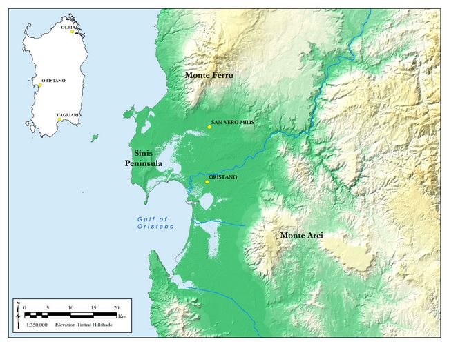
Fig.1: View of west-central Sardinia.
To this end, the Sinis Archaeological Project uses multi-scalar regional survey and targeted excavation to explore settlement patterns, landscape use, and colonial interactions in west-central Sardinia, a particularly varied landscape from both environmental and cultural perspectives (fig.1). Our primary research questions include:
• How were the diverse landscapes (agricultural plains, mountains, coastal regions, and inland hills) used over the course of the 1st millennium BCE and beyond? Can changing patterns of exploitation and settlement be detected over time? How does contemporary landscape use impact the archaeological remains?
• To what extent did Phoenician, Punic, and Roman colonial interaction impact each of these landscapes? Were there major differences between colonial interaction in urban and rural environments, or between landscapes with different resources (agricultural vs. mountainous)?
• How were indigenous Nuragic sites perceived and used by foreign colonizers? What imported material or outside influence can be observed at these sites? By contrast, what material culture shows continuity of local traditions? What local influence can be observed at sites of colonial foundation?
Previous Work at the Site:
Our work builds upon previous work in the region. From 2015-2017, we completed a site-based survey at the Nuraghe S’Urachi (San Vero Milis), one of the largest Nuraghic stone towers in our survey region (Gosner and Smith 2018). This site was partially excavated by Giovanni Lilliu in the 1940s, and the neighboring settlement of Su Padrigheddu has also been explored (Lilliu 1950; Roppa 2015). Since 2013, the Progetto S’Urachi—jointly run by Brown University and the Comune di San Vero Milis—has conducted large scale excavations to explore daily life and cross-cultural interactions at this site in the 1st millennium BCE (Stiglitz et al. 2015). Many other Nuragic and colonial sites have been excavated across west-central Sardinia. Among the most prominent are the coastal sites of Tharros (Zucca 1993; Acquaro and Finzi 1986) and Cornus (Zucca 2016; Blasetti Fantauzzi and de Vincenzo 2013).
While archaeological survey is less common than excavation in Sardinia, several surveys provide important precedent for our work. The University of Maryland-Wesleyan Survey focused on the inland central hills and mountain ranges directly east and south of our proposed survey region near the Roman sites of Fordongianus and Usellus (Dyson and Rowland 1992). The Riu Mannu Survey targeted the Riu Mannu river valley, located south of the city of Oristano, and south of our proposed survey region (van Dommelen 1998). More recently, the Capo Mannu Survey investigated the cape in the northwest of the Sinis Peninsula. One of our challenges will be to integrate our new survey data with these existing surveys and excavations.
Sinis Archaeological Project: 2018 Funded Research (RFF-2018-54)
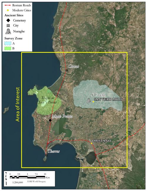
In June 2018, we held our inaugural field season funded in large part by the Rust Family Foundation. Our work focused on the exploration of the plains of the Upper Campidano surrounding the large, inland Nuragic site of S’Urachi (Comune di San Vero Milis, Oristano, Sardinia). This is a region of flat plains cut by natural rivers, man-made canals and irrigation channels. Today, agriculture and pastoralism are the dominant activities in this rural landscape. We refer to this territory as Zone A, while future survey areas will be named Zone B, C, and D (fig.2).
Fig.2: View of the wider region of interest to the project (within the rectangle). Survey Zones A and B are delineated.
Goals:
Our primary goals for our inaugural 2018 season were to:
• Explore patterns of land use, resource acquisition, and settlement in the inland territory of Zone A using archaeological survey.
• Provide new data to contextualize the ongoing excavations at the important site of S’Urachi in their regional setting.
• Refine our project methodology for implementation in the wider survey region over the next four years.
Methodology:
The Sinis Archaeological Project employs a multi-scalar methodology to assess the landscape: regional reconnaissance at the largest scale, pedestrian survey at the intermediate scale, and intensive scatter-based collection and/or targeted excavation at the smallest scale. Regional reconnaissance involves evaluating satellite imagery and existing publications to gather information about the landscape and locate known and probable archaeological sites. In the field, the team then visits these sites to verify and further document them through drawing, photography, photogrammetry, and written records. This is supplemented by additional recording using a drone, or unmanned aerial vehicle (UAV) to collect high resolution imagery and near-infrared data, which is used to better document features that may be obscured by vegetation, as well as to create 3D models of sites for measurement and analysis.
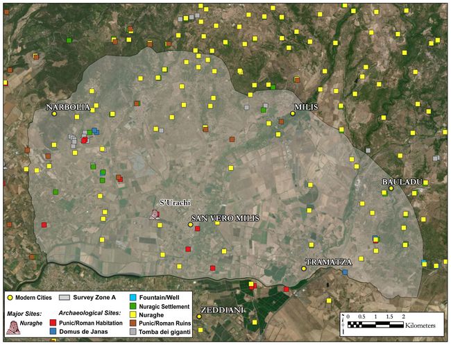
Fig.3: Map of Zone A based on survey data, remote sensing, and previously published maps of the region.
Pedestrian survey assesses the landscape systematically at the intermediate scale. Here, the team systematically traverses the landscape at 10m spacing, collecting artifacts from the surface and recording any archaeological features encountered. Artifacts are then analyzed and distributions are created in GIS to understand chronological patterns in the use of the landscape.
Finally, at the smallest scale, intensive scatter-based collection or targeted excavation is used. This involves full collection of material at points laid out across a grid over a known site. In areas where material distributions or surface finds suggest that excavation would enhance results, small-scale excavation can be carried out. Our methodology for this small-scale, site-based approach was devised in our 2015-2017 survey at the site of S’Urachi.
Results:
In 2018, our work focused on intermediate-scale pedestrian survey and features recording in Zone A (fig.3). We systematically traversed agricultural fields with our team, counting and collecting artifacts on the surface. Through mapping of our survey units and analysis of the materials, we produced maps that help us understand the chronologies of landscape use. In all, we surveyed 226 units, totaling approximately 1.3 square kilometers.
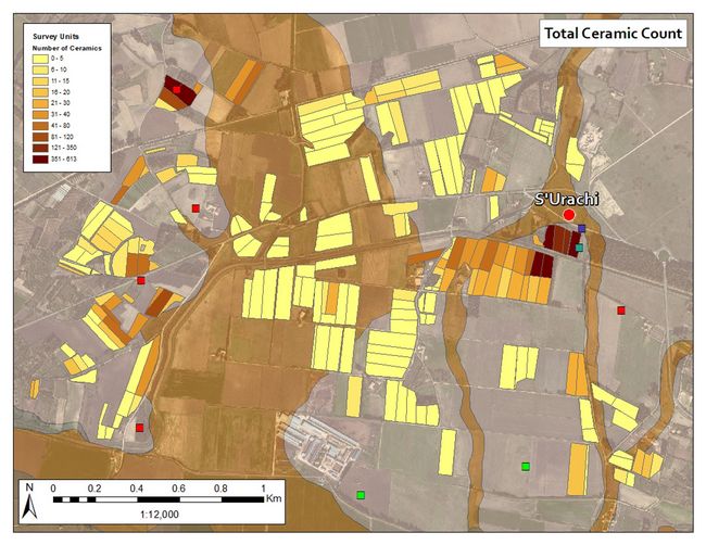
The data we compiled shows the intensity of landscape use around S’Urachi in the ancient past. It also shows concentrations of ceramic farther from the site that represent the occupation of smaller sites in the wider territory in areas above the alluvial plain, which was likely subject to periodic flooding in antiquity.
Fig.4: Map depicting the total ceramic count.
The frequency of modern trash and modern ceramic across the region demonstrates how much the landscape has changed, as more land has been converted for use in year-round agriculture and farmsteads that can now be located in zones which may not have been suitable for habitation in antiquity. Fig.4 shows a map of our overall ceramic distributions across the survey units.
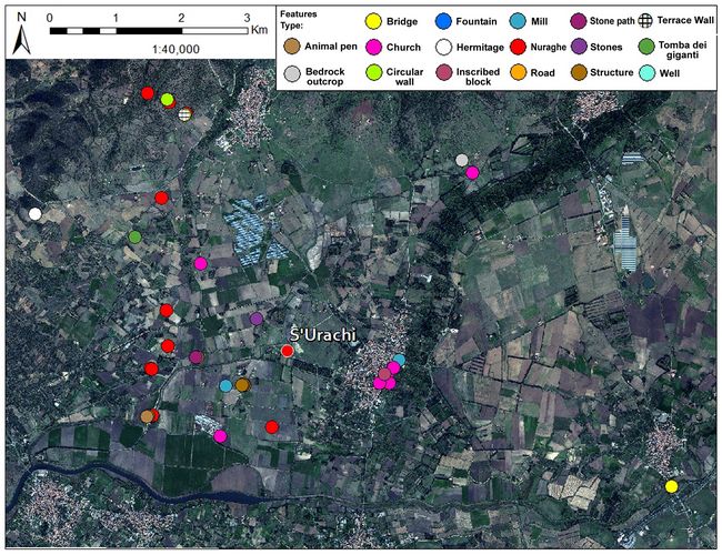
Fig5: Map of features documented in 2018.
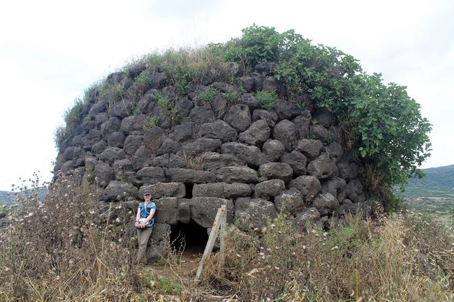
In addition to our pedestrian survey, we undertook regional reconnaissance in and around Zone A to better understand the distribution of sites in the wider landscape and to document known sites and features. We compiled a map of Zone A with hundreds of known and potential archaeological sites based on existing publications and government data. We visited many of these places, documenting 37 features through traditional photography, photogrammetry, drawing, and aerial photography using our drone (fig.5). These included features ranging in date from the Bronze Age to the 19th century: nuraghi (fig.6), quarries, ancient roads, animal pens, rural Christian churches, historic farm houses, and historic water-powered grain mills, among others.
Our work in 2018 allowed us to experiment with the implementation of our methodology and to draw several important observations. The site of S’Urachi, while the largest and most prominent of Zone A, was situated in a landscape full of a number of smaller sites. Most archaeological sites, further, show signs of reuse and reoccupation over time. For instance, many sites that have been previously classified as “Nu
 ragic”
were modified in later periods for diverse purposes.
ragic”
were modified in later periods for diverse purposes. Fig.6: Nuraghe Accas in the northern sector of Zone A.
Finally, the management of water for agriculture and other uses has been–and continues to be–of significant importance to agricultural exploitation and habitation in this region. We look forward to continuing the survey and enhancing our preliminary results with further analysis in the coming years.
__________________________________________________________________________
Bibliography:
Alcock, S. and J. F. Cherry eds. Side-by-Side Survey: Comparative Regional Studies in the Mediterranean. Oxford: Oxbow Books, 2004.
Acquaro, E. and C. Finzi. Tharros. Sassari: Carlo Delfino Editore, 1986.
Blasetti Fantauzzi, C. and S. de Vincenzo. Indagini archeologiche nell’antica Cornus (OR). Le Campagne di Scavo 2010 – 2011.” Fasti Online Documents & Research Italy Series, no. 275 (2013): 1-16.
Dyson, S. and R. Rowland. “Survey and Settlement Reconstruction in West-Central Sardinia.” American Journal of Archaeology 96, no. 2 (1992): 203-224.
Gosner, L.R. and Smith, A.J. Landscape Use and Local Settlement at the Nuraghe S’Urachi (West-Central Sardinia): Results from the First Two Seasons of Site Survey (2014-2015). Fasti Online Documents & Research Survey Series 7 (2018):1-27.
Hayne, J., E. Madrigali and A. Roppa. “Continuità e innovazioni formali nei materiali da S’Urachi: un riflesso di interazione tra Nuragici e Fenici,” in Momenti di continuità e rottura: bilancio di trent’anni di convegni. L’Africa Romana. Atti del XX Convegno Internazionale di Studi, Alghero – Porto Conte Ricerche, 26-29 settembre 2013. (L’Africa Romana 20), edited by P. Ruggeri, 1769-1779. Rome: Carocci, 2015.
Lilliu, G. “Scoperte e scavi di antichità fattisi in Sardegna durante gli anni 1948 e 1949.” Studi Sardi 9 (1950): 394-561.
Panico, B. “I paesaggi di S’Urachi.” In Tharros Felix 4, edited by A. Mastino, P.G. Spanu, A. Usai and R. Zucca: 111-8. Rome: Carocci, 2011.
Roppa, A. “L’età del Ferro nella Sardegna centro-occidentale. Il villaggio di Su Padrigheddu, San Vero Milis.” Fasti Online Documents & Research Italy Series, no. 252 (2012).
--- “La ceramica fenicia da nuraghe S’Urachi e dal villaggio di Su Padrigheddu (San Vero Milis, Sardegna): aspetti cronologici e funzionali.” Onoba 3 (2015): 129-146.
Roppa, A., J. Hayne and E. Madrigali. “Interazioni artigianali e sviluppi della manifattura ceramica local a S’Uraki (Sardegna) fra la prima età del Ferro e il periodo punico.” Saguntum 15 (2013): 115-137.
Smith, A. and P. van Dommelen. "Monumental Engagements: Cultural Interaction and Island Traditions in the West Mediterranean." In Regional Approaches to Society and Complexity: Studies in Honor of John F. Cherry. Monographs in Mediterranean Archaeology 15, edited by A. Knodell and T. Leppard. 158-181. Sheffield: Equinox, 2017.
Stiglitz, A. “Archeologia di un paesaggio: il Sinis (Sardegna centro-occidentale).” In La ceramica nel Sinis dal Neolitico ai giorni nostri. La ceramica racconta la storia 2, edited by C. Cossu and R. Melis, 23-55. Cagliari: Condaghes, 1998.
--- “Fenici e Nuragici nell’entroterra tharrense.” Sardinia, Corsica et Baleares Antiquae 5 (2007): 87-98.
Stiglitz, A., E. Díes Cusí, D. Ramis, A. Roppa and P. van Dommelen. “Intorno al nuraghe: notizie preliminari sul Progetto S’Urachi (San Vero Milis, OR).” Quaderni della Soprintendenza Archeologica per le province di Cagliari e Oristano 26 (2015): 191-218.
Tore, G. “Per una rilettura del complesso nuragico di S’Uraki, loc. Su Pardu, San vero Milis – Oristano (Sardegna).” In The Deya Conference of Prehistory: Early Settlement in the Western Mediterranean Islands and the Peripheral Areas, edited by W. Waldren. BAR International Series 229 (1984): 703-724.
--- “San Vero Milis, loc. Su Pardu, complesso nuragico e villaggio punico-romano di S’Uraki.” In I Sardi. La Sardegna dal paleolitico all’età romana, edited by E. Anati, 203-20. Milano: Jaca Books, 1984.
van Dommelen, P. On colonial grounds: a comparative study of colonialism and rural settlement in first millennium BC west central Sardinia. Archaeology Studies Leiden University, 2. Leiden: University of Leiden, 1998.
Zucca, R. Tharros. Oristano: Giovanni Corrias,1993.
--- Archeologia della Sardegna Romana. Sassari: Carlo Delfino Editore, 2016.
Recent Foundation grants: general Archaeology Grants Program w/map
Copyright © 2019 Rust Family Foundation