Rust Family Foundation: Archaeology Grants Program
Rural Archaeology in the Upper Indus Valley--
Monitoring and Preserving an Urban Process on the Old Beas River
Principal Investigator: Professor Rita P. Wright
Center for the Study of Human Origins
Department of Anthropology, New York University
Importance of the site and project:
Studies of urbanism in the Indus civilization have focused on its early cities but documentation of its secondary centers and rural settlements has been incomplete. This research, for the first time in Indus studies, focuses on rural settlements and their contribution to regional development and urbanism near the ancient city of Harappa. Eighteen Indus sites situated on the now dry bed of the Beas River (fig.1) complement excavations carried out in the city by establishing settlement histories that began in early and ended in later phases of the excavated levels at Harappa, now dated from 3300 BCE to ca. 1800 BCE and possibly later. The presence of comparable ceramics, small find indicators and 26 radiocarbon indices parallel Harappa’s chronology and complement the settlement history of the region.
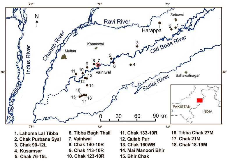
Fig.1: Map showing location of sites along the Beas River.
Our survey data and geoarchaeological research have established that human settlement of this region was coincident with a stabilized river regime. Two major river systems, the Ravi and the Sutlej define the landscape. The Bari Doab, the interfleuve between the Ravi and the Sutlej is a ridge of high land running the length of the survey area and the location of the majority of settlements on the old Beas River. Mounds distributed along this landscape were built on or at the margins of the ridge referred to as doabs which formerly were well-drained segments of the alluvial plain.
Previous research in the region:
Recent excavations at Harappa have focused on mapping the rise and decline of the ancient city based upon a well-defined stratigraphic sequence. Regional studies have been limited to a large-scale reconnaissance survey conducted between 1992 to 1996 by the Pakistan Archaeological survey (PAS) funded by the Department of Archaeology, Government of Pakistan. Its goal was to identify prehistoric and historic settlements and monuments. While results of the PAS provided a general picture of long-term settlement trends and baseline information, our research focused on a close documentation of the cultural and natural stratigraphy of the Beas settlements using systematic survey methods, not feasible by the PAS. This research took place between 1996 and 2001during which we conducted field surveys. Permission to carry out field work was discontinued in 2001 due to political conflicts.
2018 Funded Research Project (RFF-2017-52):
Goals:
1. Reconstruction of the environmental and cultural histories of the onset, duration, and abandonment at each site.
2. Establishment of a mapping and sampling program with which to refine chronologies and state of preservation at all Beas settlements.
3. Documentation of production debris and features in field surveys to identify economic activities, structures and site infrastructure.
Methodologies:
One hundred percent of each site was surveyed regardless of its state of preservation using a system of quadrats from which collection units were randomly selected. Data collection involved scraping surfaces, weighing and counting pottery sherds, small finds, and production debris in the sampling units. In some instances, 10,000 objects were recorded in a single 5 x 5 m collection unit. Diagnostic artifacts were examined in the pottery yard and entered into a database, while others were left in situ for future excavation. Contours and spatial distributions were plotted and mapped. Limited test trenching and coring were carried out at selected sites where permissions were granted.
Mapping:
The linear configuration of sites along the Beas comprised small and large settlements in various stages of preservation. The mapping and artifacts from the site of Vainiwal are examples of how the Rust Family Foundation funds assisted in completing our research.
In order to document the current conditions of each site, contour maps were prepared in the field and completed in the lab at NYU, using ArcGIS 9.2. Rust Family Foundation funds were granted to upgrade 18 site maps using ArcGIS, 10.4.1.
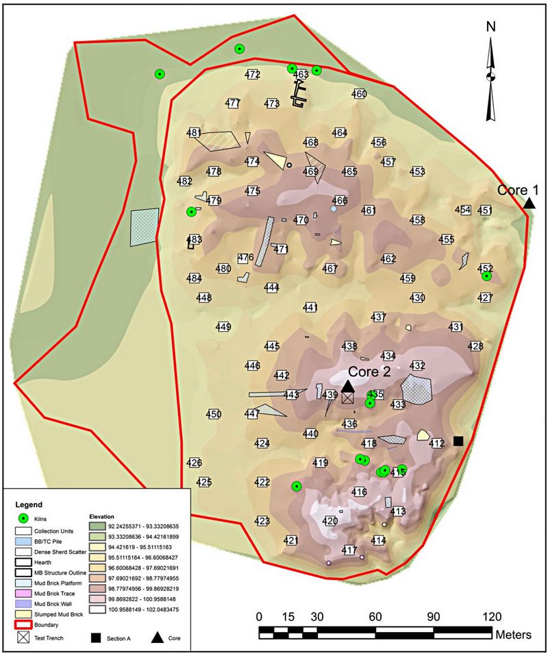 The
Vainiwal landscape (fig.2) comprised three mounds north, central, and
south. The north mound had remnants of mudbrick and construction
debris. The central mound was an eroded platform and at its
highest point was estimated at 10.7 meters. The south mound was the
most prominent, estimated at 10 to 15 meters in height. The numbered
rectangles are collection units based on a system of quadrats.
These 5 x 5 meter units were selected at random and covered 100% of the
site.
The
Vainiwal landscape (fig.2) comprised three mounds north, central, and
south. The north mound had remnants of mudbrick and construction
debris. The central mound was an eroded platform and at its
highest point was estimated at 10.7 meters. The south mound was the
most prominent, estimated at 10 to 15 meters in height. The numbered
rectangles are collection units based on a system of quadrats.
These 5 x 5 meter units were selected at random and covered 100% of the
site. Fig.2: GIS map of Vainiwal.
In addition to contour intervals, shown on fig.2, other landscape features were visible based on an extensive surface scraping and plotting of two topographical transects, detailing spatial distributions of structures, surface mudbrick traces, evidence of walls and activity areas. Surface GIS field mapping and photographs were combined with examination of digitally enhanced Google Earth satellite modern site photos and historic Corona satellite imagery (Wright and Hritz). The Google Earth images were digitally enhanced, adjusting brightness/contrast and color saturation levels to emphasize site features that were less clear from the surface, human observer perspective (fig.3).
On the north mound the primary materials discovered in the assemblages were nodules and sherds. Nodules are highly vitrified clay, often combined with ash, and used as fill for foundation materials in constructing buildings for which there were surface traces. On the central and south mounds, the substantial deposit of mud brick visible on the saturated images and the contour lines on the GIS map, corresponded to the mudbrick visible in the field. The central mound platform is at its highest point at 101.7 meters. The highest point on the south mound is more or less two meters higher at its highest recorded point and is most prominent. This is a relational estimate, since 100 meters was used as an arbitrary elevation set for the datum as was recorded on the GIS maps.
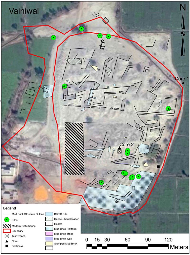 The ongoing
destruction of Vainiwal is noted by the large area indicating modern
disturbance on the central mound (fig.3). Ponds visible on color images on the
south mound were not present in 2001.The encroachment of
agricultural fields on the cultural remains is clearly visible on
Google Earth images.
The ongoing
destruction of Vainiwal is noted by the large area indicating modern
disturbance on the central mound (fig.3). Ponds visible on color images on the
south mound were not present in 2001.The encroachment of
agricultural fields on the cultural remains is clearly visible on
Google Earth images. Fig.3: Surface GIS overlay on Google Earth image of Vainiwal.
Artifact Illustration:
Funds also were granted for digitizing hand-drawn artifact illustrations originally prepared in the field.
12,451 sherds were collected and described from Vainiwal. 88% were identifiable. Artifact illustrations prepared in the field were redrawn in Adobe Illustrator and Photoshop. Ceramic attributes included vessel form, exterior and surface treatment, and color coded using a Munsell chart. Production related factors included overfiring of material remains, potter’s tools, and other small finds (n=3,506). One thousand small finds and 2,500 pottery sherds were treated by curators at the Harappa Conservation Laboratory. A sample of publishable drawings and all maps will be curated in an archive, published, and transmitted to the Government of Pakistan.
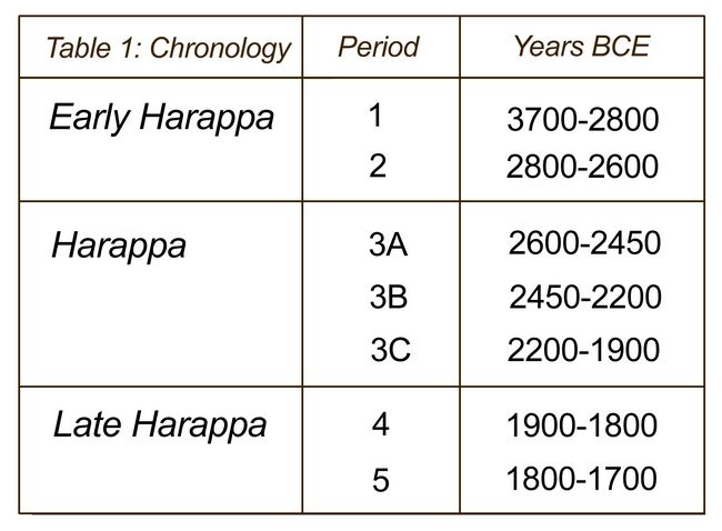
We used a chronology established at Harappa that spans the initial founding of the settlement to the end of the Harappan periods. The dates are based on stratigraphic sequences and diagnostic ceramic types, as shown in table 1:
 There
were twenty-six radiocarbon and AMS dates from test trenches and cores
on the Beas survey sites. Of these, four recorded at Vainiwal
fall within the ranges of the Harappa periods: Periods 1 and 2
(2870 ±40 BCE); Period 3A (2475±70 BCE); Period 3B (2445±40 BCE);
Period 3C (2280 ±60 BCE).
There
were twenty-six radiocarbon and AMS dates from test trenches and cores
on the Beas survey sites. Of these, four recorded at Vainiwal
fall within the ranges of the Harappa periods: Periods 1 and 2
(2870 ±40 BCE); Period 3A (2475±70 BCE); Period 3B (2445±40 BCE);
Period 3C (2280 ±60 BCE). Table 1: Chronology at Harappa.
The diagnostic ceramics match protocols as follows:
Diagnostic ceramics:
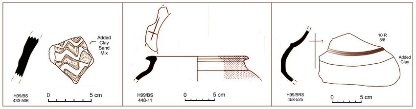
Fig.4: Left fragment: This hand formed vessel has a raised appliqué design produced by adding clay and a sand mixture to create the wavey line pattern comparable to period 1. Center fragment: This jar has a beaked rim, shoulder, and red slip. Its rim is characteristic of period 2. Right fragment: This cooking pot may be hand formed and could be period 2/3.
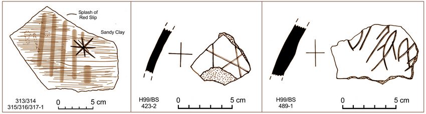
Fig.5: Left fragment: This red slipped sherd fragment is typical of periods 1 and 2, but the single post-firing graffiti identifies it with phase 1. Center fragment: The post-firing more complex graffiti identifies this sherd with period 2. Right fragment: The Indus script on this ceramic fragment identifies this sherd with Harappa period 3.
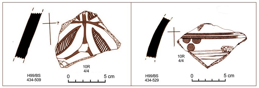
Fig.6: Left fragment: The vegetal design represented on this sherd is typical of period 3A/B. Right fragment: The “berry” design on this sherd, painted in black and red, is from period 3, most prevalent in 3A.
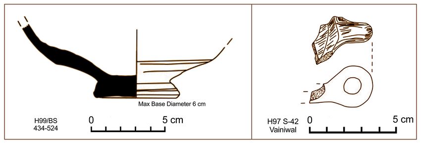 Fig.7:
These two fragments are from an unspecified phase in period 3. The
large pot at left has a non-contiguous, discoid base. To its
right, the handle shown is from a small bowl.
Fig.7:
These two fragments are from an unspecified phase in period 3. The
large pot at left has a non-contiguous, discoid base. To its
right, the handle shown is from a small bowl. 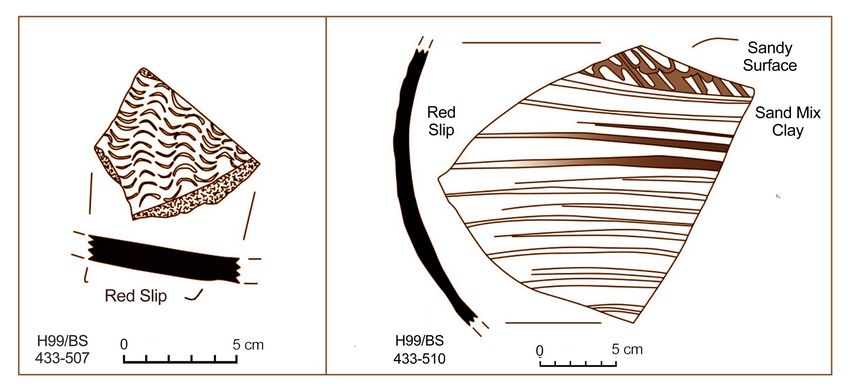
Fig.8: Left Fragment: This red slipped sherd has an unusual design, possibly birds in flight. No type from Harappa has been published, but it compares to Late Harappan ceramics from a surface survey identified by R. Mughal (1997). Right Fragment: This red slipped sherd compares to applique and incised pottery. Its sandy surface and mud applique conform to the wet wares identified by R. Mughal (1997) in the Late Harappan, periods 4 and 5.
Small Finds (Figurines and Ornaments):
Figurines are identified by animal and design variation. Chronologically sensitive attributes on figurines depend on body features characteristic of certain animals. Ornaments are identified by method of manufacture.
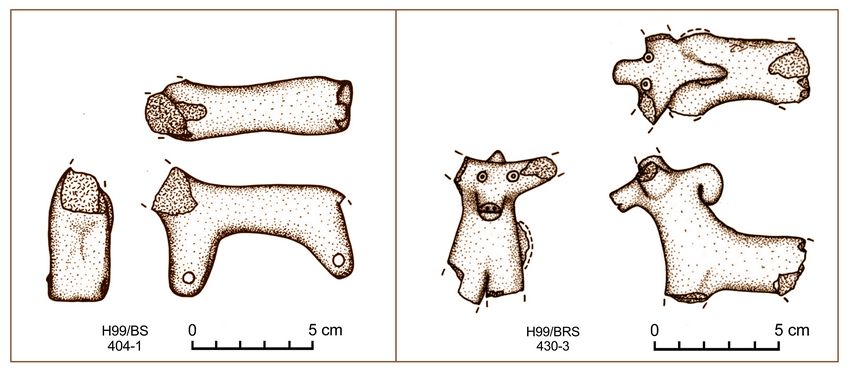
Fig.9: Left fragment: The wheeled clay cart has comparable features to one found at Harappa. The holes linked body parts of the sheep with string and is identified with Periods 2 and 3A. Right fragment: The zebu with a dolup and prominent eyes, is comparable to a figurine at Harappa identified by Clarke (2016) in 3 B/C.
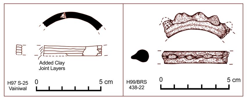 Fig.10: Left
Fragment: the ceramic bangle produced in four clay layers places this
fragment in period 2. Right Fragment: this faience bangle with a
distinctive design identifies it in Period 3 or, more likely, Period 4.
Fig.10: Left
Fragment: the ceramic bangle produced in four clay layers places this
fragment in period 2. Right Fragment: this faience bangle with a
distinctive design identifies it in Period 3 or, more likely, Period 4.Contributions of the Research:
The results of the Beas survey are providing important evidence for the development of urbanism in the Upper Indus Valley. Although Harappa was one of the first major cities to develop in this region, the timing of rural settlement began at around the same time. Our research methodology, systematic sampling and 100% coverage of surfaces, offers strong evidence for a parallel development of periods of expansion and decline. At mounds like Vainiwal and some others, again as a result of our 100% coverage, significant economic activities such as a thriving pottery industry, took place beyond Harappa’s gates. Our ability to trace evidence for mudbrick structures under certain environmental conditions and seasonal variations provide a lasting image of a thriving community, as conditions at the site changed. The building of massive structures, on the central mound and more prominent on the south mound, provide additional insights into the community setting. The construction of these massive “platforms,” is a powerful statement of local leadership. Based on available data, this is the first time a structure of this kind has been found at a relatively small, rural settlement and not at a major Indus city. We plan to continue to monitor site destruction and seasonal variation through the newly available Google Earth imagery.
Bibliography:
Clark, Sharri R.
2016. The Social Lives of Figurines: Recontextualizing the Third Millennium B.C. Cambridge, Mass. Peabody Museum.
M.R.Mughal.
1997. Ancient Cholistan. Archaeology and Architecture. Lahore: Ferozsons (Pvt) Ltd.
Wright, R. and C. Hritz.
2013. Satellite Remote Sensing Imagery. New Evidence for Site Distributions and Ecologies in the Upper Indus. In D. Frenez and M. Tosi, South Asian Archaeology 2007, Vol. 1. BAR International Series 2454.
The maps of Vainiwal were prepared by Mark Smith, Zenobie Garrett, Laura Jo Miller, and Rita Wright. The artifacts were prepared by Giulia Gallo [do not duplicate either the maps or artifacts without permission from R. Wright © ]. Chris Jenkins and J.M. Kenoyer assisted in the identification of ceramic parallels for two Vainiwal sherds at Harappa; Sharri Clark, of a figurine; and Eli Dollarhide, preparation of this report.
Recent Foundation grants: general Archaeology Grants Program w/map
Copyright © 2019 Rust Family Foundation