Rust Family Foundation: Archaeology Grants Program
Contact Period Occupation of Stage Island Harbor,
Cape Porpoise, Kennebunkport, Maine
Principal Investigator: Tim Spahr
Kennebunkport Conservation Trust
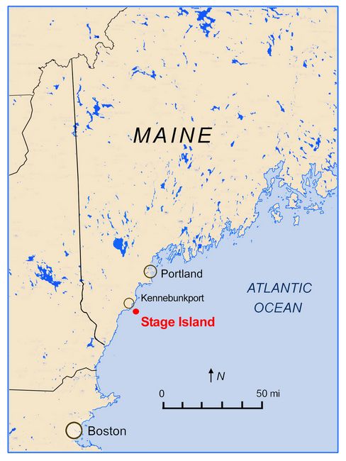 :
:Stage Island, located on the southern coast of Maine near Kennebunkport (fig.1), holds important archaeologieal information. Situated at the mouth of Samson Cove less than 1/2 km off the coast of Cape Porpoise, Maine, and measuring 34 acres, it is the northernmost of nine islands surrounding the entrance of Cape Porpoise Harbor (fig.2). Stage Island is owned by the Kennebunkport Conservation Trust, a nonprofit organization dedicated to preserving natural lands and historic places in greater Kennebunkport.
Fig.1: Map showing location of Stage Island in southern Maine.
Preliminary evidence indicates this island was populated by Native Americans and some of the first Europeans to arrive in northern New England in the late sixteenth century. This also suggests there was interaction between the two cultures. Historic records of Contact Period interface in this area is limited. There are few writings and no known maps. Therefore, attaining information requires archaeological research.
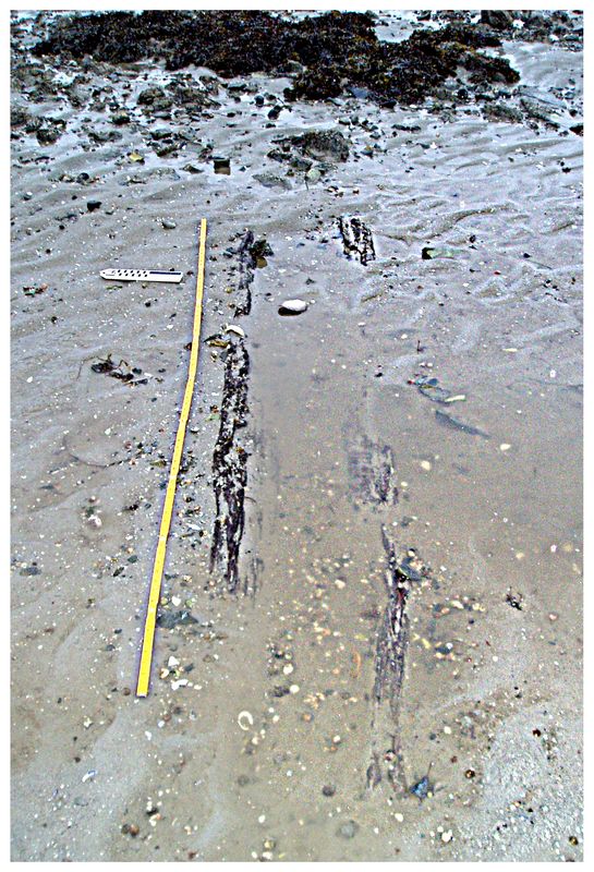
Historic evidence on Stage Island includes building foundations; field cairns and the possible remnants of a fort. Prehistoric evidence includes the likely remains of a fish weir associated with Woodland-Ceramic Period occupation (2800 to 400 years before present) (fig.4). Recently, remains of a wooden canoe have also been discovered (fig.6), currently being dated by radiocarbon (14C) analysis.
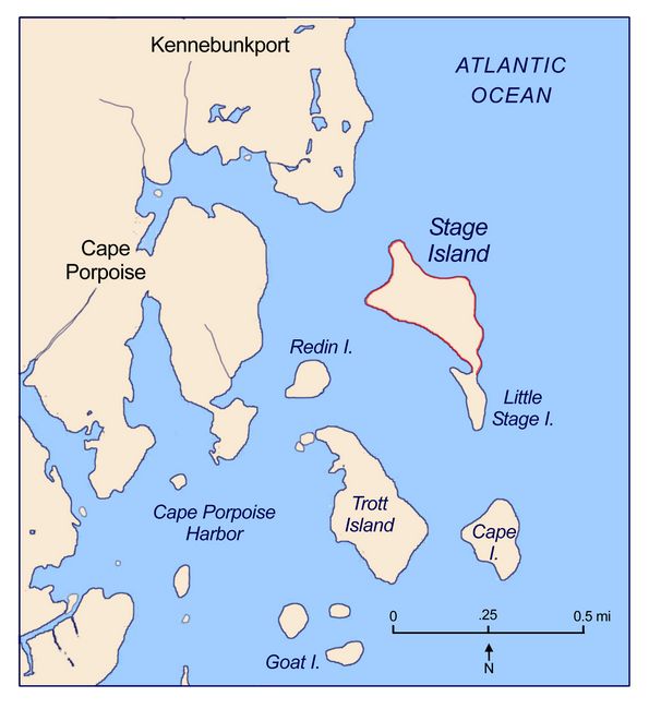
Fig.2: Location of Stage island and adjacent islands at Cape Porpoise, Maine.
An archaeological survey conducted in September 2016 located pre-Contact Period artifacts (fig.5). Over the last several years a number of Prehistoric stone objects from the Middle Archaic through Woodland-Ceramic Periods have been located on the island's surface and inter-tidal zone. This increased number of artifacts, however, is not a good sign. Rising sea level due to climate change is eroding Stage Island into the sea. Artifacts and features preserved in their original provenience for thousands of years are being washed away and strewed about the coast. Archaeological sites are disappearing. Evidence of Prehistoric and Contact Period civilizations that once inhabited this small coastal island is vanishing. Only five miles away, Strawberry Island has already succumbed. Home to a working farm in the 1940s, it is now pile of rocks submerged at high tide.
Historic Sources:
Although Cape Porpoise was not incorporated as a town until 1653, it was inhabited by Europeans as early as 1602 and settled by 1623, with Stage Island being the first area of Cape Porpoise to be occupied (Bradbury 1837). Admiral John Smith is credited for naming Cape Porpoise in 1614, but English explorer Bartholomew Gosnold probably landed there previously in 1602, having named Cape Porpoise "Northland" (Bradbury 1837: 17-18). French explorer Samuel de Champlain also visited Cape Porpoise in 1604 (Freeman 1955:5).
Early Historic Period writings by seventeenth century English explorers John Smith (1580-1631), Bartholomew Gosnold (1571-1607) and John Brereton (1571-1619?) and nineteenth century historian Charles Bradbury (1799-1860?) suggest that Stage Island Harbor, including Stage, Redin, Trott, and Cape Islands (fig.2), and the intertidal zone that lies between, were occupied by Native Americans during the late Ceramic, Contact and early Historic Periods. Smith, Gosnold and Brereton, who sailed from England, kept written records describing their encounters with Native Americans along the coast of New England.
ln 1837, Charles Bradbury published The History of Kennebunkport from its First Discovery by Bartholomew Gosnold, May 14, 1602 to A.D. 1837. Bradbury's writings are an historical account based on his research of early records, offical documents, and private papers, with over 200 references including the writings of Smith, Gosnold, and Brereton, and a bibliography.
Previous Work at the site:
ln 2002, a maritime archeological survey of Cape Porpoise Harbor was conducted by Stefan Claesson. He recorded the stone remains of a Historic Period sheep shelter and stone water well.
 Artifacts
located on the intertidal zone of Cape Porpoise Harbor, to include
Stage Island, further indicate the area was occupied by Native
Americans. Over the last several years, Tom Bradbury, Executive
Director of the Kennebunkport Conservation Trust, along wth Trust patron
Kathy Cmaylo, located stone artifacts that are consistent with those
made by Ceramic Period Native Americans (3000 to 500 years ago). In
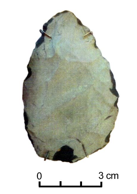
2013, five individual stone tools including chert and rhyolite
projectile points and a rhyolite hand tool were found on the surface of
the intertidal zones of Cape Porpoise islands (fig.3).
Artifacts
located on the intertidal zone of Cape Porpoise Harbor, to include
Stage Island, further indicate the area was occupied by Native
Americans. Over the last several years, Tom Bradbury, Executive
Director of the Kennebunkport Conservation Trust, along wth Trust patron
Kathy Cmaylo, located stone artifacts that are consistent with those
made by Ceramic Period Native Americans (3000 to 500 years ago). In
2013, five individual stone tools including chert and rhyolite
projectile points and a rhyolite hand tool were found on the surface of
the intertidal zones of Cape Porpoise islands (fig.3). Fig.3: Rhyolite biface found at Trott Island, probably dating from the Ceramic Period.
In 2014, Tim Spahr recorded the stone remains of a probable fish weir located in the harbor's intertidal zone (fig.4). In 2016, the Kennebunkport Conservation Trust began Part 1 of a 4-phase archaeologieal survey of Stage Island (fig.5), of which the current project constitutes phase 4.
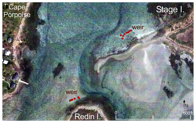
Fig.4: Aerial view of fish weirs idenfified at Stage and Redin Islands.
2017 Funded Research Project (RFF-2017-50)
Goals:
Based on the writings of Smith, Gosnold and Brereton, the research of Bradbury, and archaeological field work conducted in Stage Island Harbor in 2016-17, this archaeological investigation sought to answer the question: was Stage Island Harbor a significant place of Native Ameriean occupation during the Contact Period?
Methodology and Findings:
 All
archaeological surveys involved the hand excavation of test pits in
which archaeologists employed a standardized, systematic methodology
with removal of sediment by arbitrary 10 cm (4 in.) levels with natural
soil strata from the highest point downward. All excavated sediments
were screened through 10 cm (1/4 in.) hardware cloth. Provenience
inventory forms were used to record artifacts and stratigraphy.
All
archaeological surveys involved the hand excavation of test pits in
which archaeologists employed a standardized, systematic methodology
with removal of sediment by arbitrary 10 cm (4 in.) levels with natural
soil strata from the highest point downward. All excavated sediments
were screened through 10 cm (1/4 in.) hardware cloth. Provenience
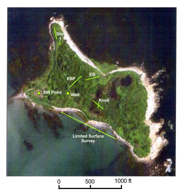
inventory forms were used to record artifacts and stratigraphy. Fig.5: Aerial view of Stage Island, showing sites identified in Part I of the Survey (EB-East Beach; EBP= East Beach Pasture).
 After
the completion of field work, all cultural remains were processed at
the Brick Store Museum Laboratory in Kennebunk by Spahr and Hudgell. At
the laboratory, artifacts were organized by provenience and
inventoried. Wet and dry cleaning methods were used as appropriate.
After
the completion of field work, all cultural remains were processed at
the Brick Store Museum Laboratory in Kennebunk by Spahr and Hudgell. At
the laboratory, artifacts were organized by provenience and
inventoried. Wet and dry cleaning methods were used as appropriate. Fig.6: Remains of a probable waterlogged canoe, discovered in 2018 on the shore of Stage Island.
Test pits and test unit profiles were measured and sketched. All depth horizon levels and object proveniences were recorded on Test Pit Profile Forms provided by Northeast Archaeology Research Center headquartered in Farmington, Maine. All paper documents have been scanned and attached to this report as part of the Appendix. All artifacts and documentation related to the Stage Island survey; including field notes and photographs are being curated by Spahr but will be accessioned to and curated by Brick Store Museum.
Conclusions:
Historic Period:
Based on the results of field work and historic research, evidence strongly suggests that Stage Island was occupied during the Ceramic Period and early Historic Periods. Bradbury (1837) notes that there was no occupation of Stage Island at the time he wrote his book in 1835. He does point out that the Island had signs of previous cultivation (Bradbury 1837: 209). Bradbury also remarks that, in his research, he located records of a land transaction on Stage Island in 1735. The transaction between seller and buyer included the area of the fort (ca. 1690, now known as Little Stage or Fort Island), a cemetery (located on a piece of land that connected Stage and Little Stage, now washed away) and a fish stage.
Early Historic Period occupation ended sometime after 1735 but was
 reestablished in the late
19th century primarily for sheep pasturing which was a wool source for
New England woolen industry. Historic Period artifacts and lithie
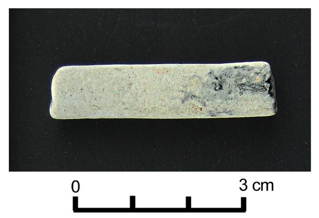
features are consistent with Euroamerican occupation after 1835 (fig.7).
reestablished in the late
19th century primarily for sheep pasturing which was a wool source for
New England woolen industry. Historic Period artifacts and lithie
features are consistent with Euroamerican occupation after 1835 (fig.7). Fig.7: Clay pipe stem from the 19th century found on Stage Island,
The sheep shelter and water well located by Claesson (Maine Archives, ME 223-056 and ME 223-057) as well as the multitude of rock cairns are indicative of late 19th century sheep pasturing. The Excelsior Supply Company bottle found on the surface and the tobacco product wrapper and nail deposit found in lithic features 22 and 23 are also products of the mid to late 19th century.
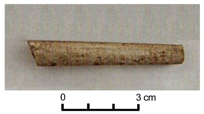
However, A clay pipe stem (fig.8) located during part 4 is suggestive of the Colonial Period (1492-1763). This pipe stem has an interior hole measuring 5/64 or 6/64 inches. Clay pipes with
 a hole diameter of 5/64 indicate
the early 1700s (1720-1750), while 6/64 likely means the late 1600s (1680-1720)
(National Park Service). Although further scrutiny is required, this is one artifact that
may pre-date the 1800s/1900s farming on the island, adding evidence of
Colonial use of Stage Island.
a hole diameter of 5/64 indicate
the early 1700s (1720-1750), while 6/64 likely means the late 1600s (1680-1720)
(National Park Service). Although further scrutiny is required, this is one artifact that
may pre-date the 1800s/1900s farming on the island, adding evidence of
Colonial use of Stage Island. Fig.8: Clay pipe stem from the Colonial Period found on Stage Island.
In addition, an excavation of the fort site was conducted in 2009 at which time considerable deposits of Historic Period artifacts were recovered. These data have not yet been processed but the results are expected to reflect late 17th and early 18th century occupation.
Pre-Contact:
Five types of pre-Contact or pre-European archaeological sites are known to exist in Maine: (1) habitation (camp or village) and workshop sites; (2) lithic quarries; (3) cemeteries; (4) rock art; and (5) waterlogged sites preserving wood or other perishables. There are about 6000 sites in the Maine prehistoric archaeological survey inventory. Habitation and workshop sites comprise the majority (over 95%) of the known archaeological locations in Maine. They exhibit evidence of a range of activities from food procurement and processing to tool manufacture and maintenance. More than 95% of these sites are located adjacent to canoe-navigable waters, whether coast, lake, river, stream or swamp, or former shorelines of the same. The majorities of sites are shallowly buried on till, sand, gravel or silt soils within 1.5 feet of the surface. Some deeply buried sites, up to three meters in depth, occur in alluvial settings along rivers and streams (Spiess, pers.comm.).
The other types of known archaeological locations are far fewer in number than habitation sites. Lithic quarry sites are mines for rock used in making stone tools. They are highly localized sites, occurring at bedrock outcrops or along exposed, stony stream and river bottoms with extensive cobble materials. Cemetery sites always exist in locations with well-drained sandy or gravelly-sand soils near a large or small river or lake shore, or within 100 yards of a major habitation site. Rock art sites occur immediately adjacent to canoe-navigable water on particular kinds of bedrock outcrops. They include both petroglyphs (rock carving) and pictographs (rock painting) and probably date within the last 3,000 years. The Sebasticook fish weir is the only example of a waterlogged site in Maine so far, where wooden stakes from a fish trap structure, and some associated birchbark container fragments, have been preserved in anaerobic mud for between 2000 and 6000 years based on radiocarbon dates (Spiess, pers.comm.).
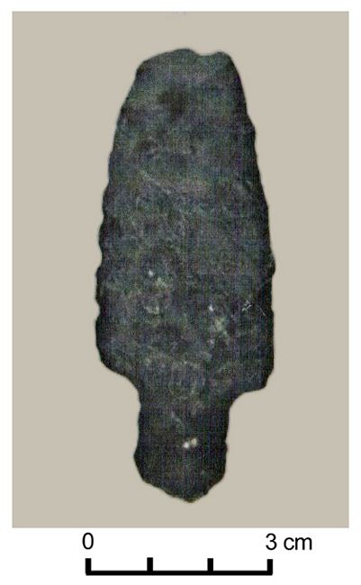
As a result of archaeological surveys part l, 2, 3 and 4 of Stage Island, pre-Contact and Historic Period occupation as speculated through historical writing, previous artifact recovery and feature documentation has been affirmed. Additional Precontact artifacts were identified as well as Historic Period artifacts and features during this multiphase survey. The hammer stone, rhyolite point, lobate base point (fig.9), and flakes located by archaeologists on the southern central portion of Stage Island and intertidal zone imply the location was a Precontact habitation and workshop site. The two weir features whose shape and size are indicative of Native American fish weirs also imply Precontact habitation and food procurement (fish harvesting).
Fig.9: Lobate base projectile point.
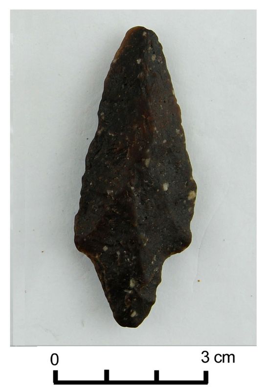
Since 2017, project archaeologists have also identified artifacts that are as old as the Middle Archaic Period (fig.10), suggesting Stage Island Harbor was occupied from about 7,000 BP to the early Historic Period, greatly expanding the local chronology. In addition, in 2018 Spahr and his coworkers discovered what appears to be the remains of a dugout canoe (fig.6), adding new evidence related to subsistence and transport. The Maine Historic Preservation Commission is preparing a sample of the canoe for Carbon 14 dating.
Fig.10: Stark/Neville projectile point from the Middle Archaic period (ca. 7,000 BP), found in 2018 in the intertidal zone of Redin Island.
In summary, the most recent field work is providing physical evidence that may help us shed light on how Precontact people adapted to geologic change that occurred during the late Archaic Period and adapted again to the migration of Europeans during the late Woodland/Ceramic Period. There is a preponderance of evidence that Stage Island and Stage Island Harbor was a place of Native American habitation (fishing village) during the Ceramic Period; that Stage Island Harbor was a place in which English explorers such as Brereton, Gosnold and Smith encountered and made contact with Ceramic Period Native Americans and that Euroamerican occupation occurred on Stage Island in two phases; between the Contact period lasting to 1735 and the later Historic Period dating from 1835 to the early 1900s.
Ongoing Plans:
The findings from the research conducted in August 2017 supports the theory that both Historic and Precontact sites are located within the harbor. However, since then, archaeologists have identified Middle Archaic Period, Stark/Neville projectile points, suggesting Stage Island Harbor was occupied from 7,000 BP to the early Historic Period (i.e., much longer than had been previously considered). This also means occupation occurred at a time when ocean levels and thus coastal landscapes, were very different. Future goals for the Cape Porpoise Archaeological Alliance, and partnership between the Kennebunkport Conservation Trust and the Brick Store Museum, are to conduct ongoing research in Cape Porpoise Harbor.
References:
Ackerman, Edward A. Harvard University.
1941 New England's Fishing Industry. University of Chicago Press. Chicago
Bradbury, Charles.
1837 History of Kennebunkport From its First Discovery by Bartholomew Gosnold May 14, 1602 to A.D. 1837. Durrell Publications.
Brereton, John.
2003 A Briefe and True Relation of Discoverie of the North Part of Virginia. America Journeys Collection, Wisconsin Historical Society Digital Library and Archives.
British Heritage.
2016 Bartholomew Gosnold: The Man Who Was Responsible for England Settling the New World [Internet site].
De Bry, Johann Theodore.
n.d. Their Manner of Fishynge in Virginia. Virtual Jamestown [Internet site].
Faulkner, Alaric.
Archaeology of the Cod Fishery: Darmariscove Island. Historical Archaeology, Volume 19.
Freeman, Melville C.
1955 History of Cape Porpoise. Cape Porpoise.
Google Earth
2013, 2016 Data SIO, NOAA, Navy, NGA, GEBCO, 2016.
Hariot, Thomas.
1588 A Brief but True Report of the New Found Land of Virginia. Electronic Texts in American Studies. Libraries at University of Nebraska- Lincoln.
Hudgell, Gemma, PhD. Consulting Archaeologist.
2017 Cape Porpoise Archaeological Partnership. Personnel Communication.
Maine Historic Preservation Commission.
2002 Archives. ME223-069, ME223-056, ME223-057.
Archives. Sites 4.8,4.9,4.13,4.27, 5.4, 5.5, 5.8, 5.9 Augusta.
Maine Archaeologieal Society
2009 Maine Precontact Artifact Timeline. Edition One.
Mosher, John and Spiess, Arthur
1992 Field Season at the Hedden Site, Report for the Town of Kennebunk with Assistance fram the Maine Historical Preservation Commission. Maine Historical Preservation Commission.
[National Geographic]
2015 Sea Level Rise, Ocean levels Are Getting Higher-Can we Do Anything About it? National Geographic. Nov. 2015
National Park Service (NPS)
2017 Artifacts as Time Markers: Pipe Stem Dating. US Department of Interior, Archaeology Program [Internet site].
Smith, John
1616 A Description of New England. An Online Electranic Text Edition. University of Nebraska-Lincoln.
Spiess, Arthur.
2015-2016 Maine Historic Preservation Commission. Personal Communications, 6 0ctober 2015 and 23 December 2016
Spiess, Arthur, Mark Hedden, and Leon Cranmer.
1998 Turnpike Archaeology. Maine Archaeological Society Bulletin 38(1):1-22
Recent Foundation grants: general Archaeology Grants Program w/map
Copyright © 2018 Rust Family Foundation