Rust Family Foundation: Archaeology Grants Program
Investigations at the Munsungun Lithic Source, Maine
Principal Investigators:
Heather M. Rockwell, Ph.D. and Nathaniel Kitchel, Ph.D.
Department of Anthropology, University of Wyoming.
Importance of the site and project:
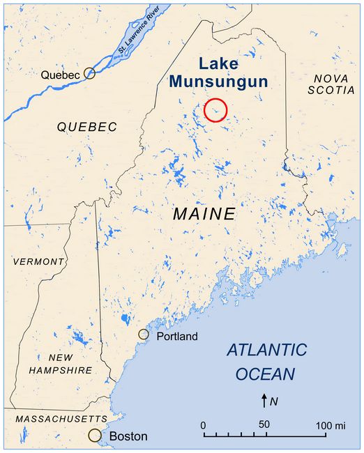
This project is part of a continuing investigation of prehistoric toolstone quarries used for the extraction of Munsungun chert in outcrops at this location in northern Maine (fig.1). Red and red and green cherts thought to be from the Munsungun Lake formation have long been known to compose important components of the lithic raw material assemblages of fluted point sites in northern New England (Pollock et al.1999). Current evidence indicates that human settlement of the Munsungun Lake region followed shortly after the retreat of glacial ice, and demonstrate use of these quarries during the early Paleoindian period in the region.
Fig.1: Map showing location of the Munsungun Lake site area in Maine.
Previous work at the site:
The red chert outcrops at Munsungun Lake were first detected in 2015 by Dr. Kitchel while conducting geoarchaeological survey in the Munsungun region. In the summer of 2015, during dissertation research, Dr. Kitchel discovered a relatively large outcrop of red and red and green chert exhibiting evidence of prehistoric quarrying activities (Kitchel and Barker 2016). This is the only location within the Munsungun Lake Formation where red and red and green cherts are associated with prehistoric quarrying activities. Findings at this location are described in detail elsewhere (Kitchel 2017). Formerly this location was dubbed the NKP Quarry, but the area has now been renamed the Stevens Site, after a local collaborator. Local toponyms are not used in names to protect the location of this sensitive site.
2017 Funded Research Project (RFF-2017-49):
Goals and Methodology:
In September 2017 our team conducted test excavations and shovel test survey on targeted landforms adjacent to prehistoric toolstone quarries used for the extraction of red Munsungun chert. We also collected geologic samples of this material from these quarry locations for additional X-Ray Fluorescence geochemical analysis.
conducting geoarchaeological survey. The block excavations undertaken adjacent to the bedrock chert outcrops were to confirm the stratigraphic profiles of a previous excavation (Kitchel 2017), while the shovel test survey was designed to locate late Pleistocene flintknapping workshops and habitation sites. The geologic samples were collected with the intent of definitively linking these red chert outcrops with red chert frequently recover from fluted point sites in northern New England.
Lithic analysis of excavated materials is ongoing; however, we have already identified a channel flake fragment as well as several unifacial scraping tools recovered from shovel test pits (STPs). The presence of a channel flake at the Stevens site demonstrates that fluted points were manufactured at this location. Scraping tools indicate domestic activities other than stone tool manufacturing took place alongside the flintknapping activities. Several STPs containing burned flakes hint at the presence of localized burning, which may indicate the presence of hearths, although further testing is required to confirm this observation. The unit excavation adjacent to the outcrop failed to produce temporally diagnostic materials, but did confirm the stratigraphic profile observed in previous seasons. XRF analysis is ongoing, but not yet complete.
Test Unit:
A test unit dubbed TU3 (Test Unit 3) was excavated one meter to the west of TU2, a test unit excavated during the summer of 2016 (Kitchel 2017). TU3 was excavated to further explore the stratigraphic associations observed previously during the excavation of TU2. Specifically at the base of TU2 cultural materials appeared to be located only centimeters
 above a layer of highly compact or indurated poorly sorted sediments
interpreted as a subglacial lodgement till. If artifacts were present
just above this stratum then the human settlement of the Munsungun Lake
region followed shortly after the retreat of glacial ice, and
demonstrate use of these quarries during the early Paleoindian period
in the region. TU3 was excavated using trowels in arbitrary 5 cm
levels, divided by soil zones. Excavated sediments were screened
through 1/4 inch mesh.
above a layer of highly compact or indurated poorly sorted sediments
interpreted as a subglacial lodgement till. If artifacts were present
just above this stratum then the human settlement of the Munsungun Lake
region followed shortly after the retreat of glacial ice, and
demonstrate use of these quarries during the early Paleoindian period
in the region. TU3 was excavated using trowels in arbitrary 5 cm
levels, divided by soil zones. Excavated sediments were screened
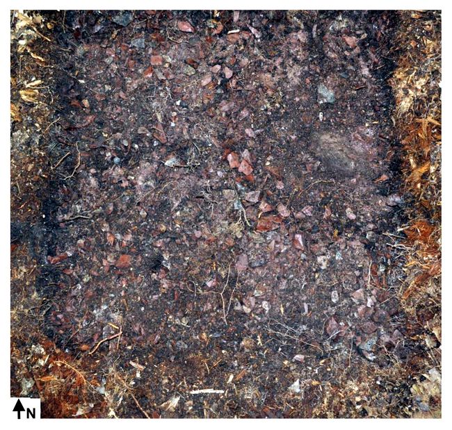
through 1/4 inch mesh.Fig.2: Quarry block layer below the leaf litter at TU3.
As observed in previous excavations, a layer of chert blocks immediately underlies the leaf litter present at this site (fig.2). We call this blocky layer zone I. This layer of tested blocks ranges from between 10 and 20 cm in thickness, with the thickness of this layer increasing towards the quarry face. Blocks are often between 10 and 20 cm in maximum dimension, although many small fragments of angular quarry debris are present. These blocks often retain little evidence of flintknapping activities beyond the occasional flake scar. We interpret these blocks to be a mixture of tested blocks and detritus from chert extraction, rather than product of tool production activities. This layer contains virtually no sediment, with obvious voids between blocks. Clast size decreases with depth while the amount of sediment between the blocks increases. Although no diagnostic artifacts have been recovered from this level, based upon the location of this layer directly below the leaf litter on the forest floor this chert block layer most likely dates to the Late Woodland (late prehistoric) period.
The stratigraphic profile below zone I observed in TU3 mirrors that of TU2. Below zone I concentrations of quarry debris and debitage drop dramatically, giving way to a Bh soil horizon with numerous flakes and some quarry blocks (zone II). Below the Bh horizon a Bs soil gradually becomes lighter in color with depth apparently giving way to unaltered redeposited till in the bottom 10 cm of the unit (zone III). Larger natural clasts consisting of some water rounded gravels and cobbles are occasionally present within these sediments. This general pattern continues to the terminus of the test unit at approximately 75 cm below surface where the highly compact layer interpreted on lodgement till is found (zone IV). Like in TU2 artifacts were located throughout the sediment column although artifact density generally decreased with depth. Lithic analysis of the materials from this test unit are not yet complete so it is unknown whether artifact concentrations rise and fall by level or zone. More importantly, however, cultural materials were once again found within three cm (vertically) of the compact lodgement till layer, confirming the presence of human populations in this region shortly after the retreat of glacial ice (Kitchel 2017: 7-8). Unfortunately, like TU2, TU3 did not contain any temporally diagnostic artifacts.
Shovel Test Pits:
Shovel test survey was targeted toward high terrace like features located approximately 20 meters above the currently elevation of an adjacent pond. These landforms were selected for shovel test survey based upon observations made during previous excavations on the margins of Munsungun Lake. At Munsungun Lake fluted point sites were found located on now abandoned high lakeshore terraces, while later occupations were located closer to the contemporary lake shore (Bonnichsen et al. 1980). Several such locations were previously noted near the access road to the site, and the driest of these was selected for additional testing. At this location an arbitrary grid was established following magnetic north, with transect and test pit locations
 determined using survey tapes.
While total station measurements would be preferable this method is
impractical given the dense vegetation at the site. Each test pit was
subsequently mapped using an Emlid RTK GPS system.
determined using survey tapes.
While total station measurements would be preferable this method is
impractical given the dense vegetation at the site. Each test pit was
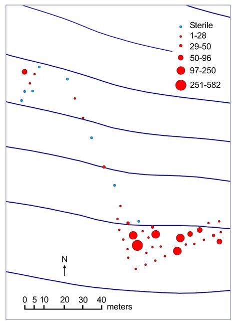
subsequently mapped using an Emlid RTK GPS system.During the course of our fieldwork our team excavated 50 shovel test pits along the established grid. Pits were excavated every four or eight meters depending on artifact density. Shovel test pits were excavated in arbitrary 10 cm levels, and stratigraphic zones. Artifact densities per pit ranged drastically from 0 (sterile) to 586 artifacts per test across the grid (fig.3). Several discretionary, or X pits, were also excavated on a small rise above the terrace like feature that was the primary focus of our survey efforts.
Fig.3: Shovel test pit locations. Discretionary pits are those pits off grid in the upper left corner. Although difficult to see because of the large contour interval, the test pit transect trends down a gentle slope with the greatest flake concentrations present on a more level terrace like feature. Circles represent artifact counts by pit.
Spatial Patterns:
Patterns of artifact density are clearly evident at the Stevens site (fig.3). Most notably discreet flake concentrations are present on the small terrace like landform where the bulk of our testing took place. It is also evident that artifact concentrations vary significantly within the terrace. It appears that these artifact concentrations represent discreet activity areas or knapping episodes. Importantly, these changes in artifact density demonstrate that spatial patterns remain within the artifact distributions on this landform, rather than a continuous homogenous scatter of flakes across the entirety of the landform. This demonstrates that with future excavations these spatially discreet artifact clusters will allow an examination of the use of space at the site, and may allow the former locations of structures and hearths to be determined through a detailed analysis of flake and artifact density (see Surovell and Waguespack 2007 for description of these methods).
Lithic Analysis:
Lithic analytical procedures generally follow those detailed in Surovell (2003: 340-353) with minor modifications. Debitage artifact types consisted of either angular debris, or flakes. Angular debris lacks all flake characteristics such as a striking platform, or obvious dorsal or ventral surfaces. Flakes greater than two cm in maximum dimension are analyzed individually, while those smaller than two cm are analyzed in aggregate. For flakes greater than two cm in maximum dimension the metric attributes of length, width, thickness, and mass are recorded, along with platform characteristics, dorsal flake scar count, and whether the item showed evidence of burning. Platform attributes recorded were plain, faceted, lipped, ground, crushed, cortical, and absent. If a flake was broken, the portion was coded as proximal, medial, distal, split longitudinally, proximal split, medial split, distal split, and indeterminate. Percentages of dorsal cortex were also recorded in categories of 0%, less than 25%, 25 to 50%, 50 to 75%, greater than 75% and 100%.
Total artifact counts from shovel test excavations taken in the field exceed 2000 items. The artifacts recovered from the test pits consist primarily of flakes, with 6.25% angular debris present. 25.5% of flakes analyzed had cortex present, and of those flakes with cortex 70% had less than 25% cortex present. The small quantities of angular debris and cortical flakes demonstrate that primarily later stage knapping activities took place at these loci with comparatively little early stage quarry block reduction. This finding shows that most primary reduction of quarry blocks took place near the quarry outcrops, while later stage bifacial blanks were transported to these workshop areas. This pattern is reminiscent of other quarry areas in the east such as Topper (Smallwood 2010),that have discreet quarry and workshop areas. Quarry areas with spatially separate workshop and camp areas are not common in the greater Northeast however. In this region few lithic quarries with associated fluted point manufacturing activities have been systematically excavated, and those that have do not have separate quarry and workshop areas (e.g. West Athens Hill [Funk 1973]). The presence of large spatially discreet quarry and workshop areas associated with fluted point manufacture makes the Stevens site unique in the Northeast.
The separation between the quarry outcrops and later stage reduction workshops has important implications for future research at the site. At quarry outcrops large quantities of naturally fractured chert, and early stage reduction debris can make the detection of technological patterns difficult, while the volume of cultural material can become unmanageable. Further, quarry areas were often disturbed by later prehistoric lithic raw material procurement activities, creating a mixed palimpsest of reduction sequences making the isolation of distinct technological practices impossible. Workshop areas like the one identified at the Stevens site provide a rare opportunity for detailed lithic technological analyses and refitting studies free from the “noise” of a highly disturbed high density quarry location. The potential to investigate lithic technological strategies during the fluted point period makes the Stevens Site one of the most important late Pleistocene archaeological sites in the Northeast.
Tools:
 Three
unifacial tools were recovered during our shovel test survey of the
Stevens site. Two of these tools resemble endscrapers, but lack the
formalized shape associated with this tool form. One possible scraper
resembles a natural fragment of stone, however microflaking on this
artifact may indicate use.
Three
unifacial tools were recovered during our shovel test survey of the
Stevens site. Two of these tools resemble endscrapers, but lack the
formalized shape associated with this tool form. One possible scraper
resembles a natural fragment of stone, however microflaking on this
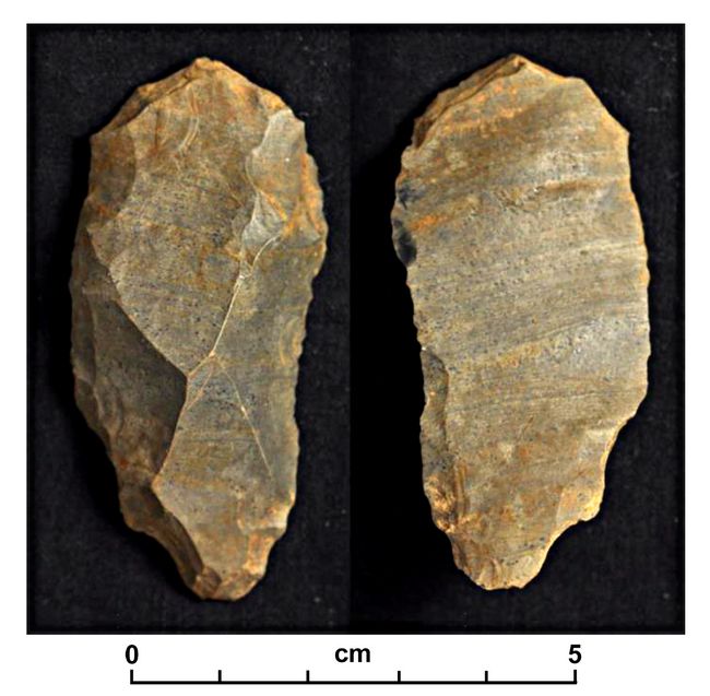
artifact may indicate use. Fig.4: Possible scraping tool (left: dorsal surface; right: ventral surface).
The second unifacial tool resembling an endscraper is a purposefully manufactured tool (fig.4). The tool, made on the proximal portion of a thick flake, is 30 mm in length, 28 mm in width and 8mm thick with a mass of 8g. The left (striking platform oriented up with ventral surface down) lateral margin is heavily retouched with microflaking present. The opposite margin shows evidence of heavy crushing and scalar flaking. Usewear analysis will be conducted on this item in the future to determine whether this tool was used, and if so on what contact materials.
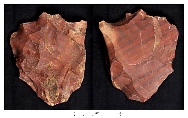
The third unifacial tool recovered resembles a sidescraper (fig.5). This tool is manufactured on a large thick flake. Retouch is present on the left lateral margin, while microflaking is present on the right. This tool will also be subject to microwear analysis in the future.
Fig.5: Sidescraper (left: dorsal surface; right: ventral surface).
A flake tool with minimal marginal retouch was also recovered. All tools were recovered within a space of 30 meters on a gently sloping bench. The location of these tools also corresponds to areas of higher flake density (fig.3). The presence of these scraping tools at this location indicates that domestic activities beyond the manufacture of stone tools took place at this location. Based on such domestic activities it is likely that this area represent a residential camp location, beyond dedicated flintknapping loci.
Bifaces:
Several bifaces and biface fragments were recovered during testing efforts, those with the most information potential are described below. Field bag number 136 is an early stage biface with square edges remaining on both margins. Retouch is not
 evident on any portion of the biface. It
is unclear whether this item was manufactured from a large flake or a
quarry block. It appears that this biface was abandoned in manufacture,
perhaps because of the remaining square edges.
evident on any portion of the biface. It
is unclear whether this item was manufactured from a large flake or a
quarry block. It appears that this biface was abandoned in manufacture,
perhaps because of the remaining square edges. Fig.6: An incipient biface made on a large thick flake. Some scalar retouch or use wear is evident on this item indicating its use as a tool (left: dorsal surface; right: ventral surface).
Field bag #127 is a fragment of a large flake (fig.6). Minimal small flakes are present on both surfaces. It is possible that this item was used as some type of tool and retouched. This item will undergo microwear analysis in the future.
 Field bag #55 (fig.7) is a biface fragment that may be the
result of radial fracture.
Field bag #55 (fig.7) is a biface fragment that may be the
result of radial fracture. Reconstructing the possible outline of this biface indicates it may have been over 9 cm in length, consistent with other examples of large Paleoindian period bifaces. No retouch is evident on this fragment. The remaining portion of this biface was not recovered.
Fig.7: Possible radially fractured biface fragment, with outline reconstruction shown by red line (left: dorsal surface; right: ventral surface).
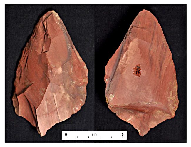
Field bag #25 is a relatively large thick biface made on a large flake (fig.8). All bifaces were recovered within the same 30m2 area as
 the unifacial tools.
Fig.8: Large early stage biface (left: dorsal surface; right: ventral surface).
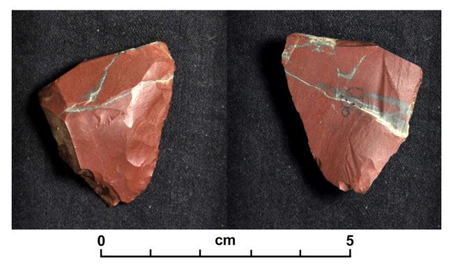
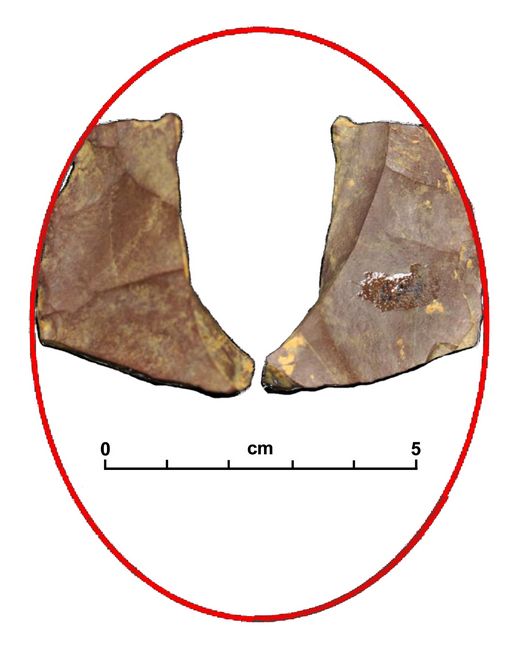
Channel Flake
Following standard archaeological protocol the channel flake was recovered during the afternoon of our final day of fieldwork (fig.9). This flake has flake scars running toward the center from both lateral margins as is diagnostic of channel flakes. The flake is relatively flat, also a diagnostic trait of channel flakes. The striking platform is crushed on this item which is unfortunate since channel flake platforms are often highly prepared, with significant grinding usually present. The presence of this artifact demonstrates that fluted points were manufactured in this location, and that other diagnostic fluted point materials, including points broken in manufacture may be found nearby.and the work previously conducted at this location
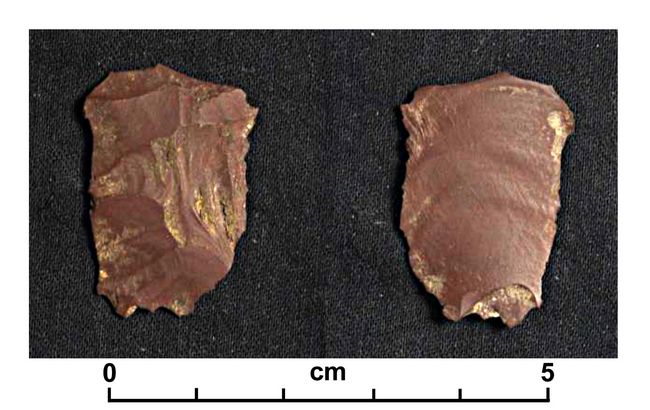
Fig.9: Channel flake fragment (left: dorsal surface; right: ventral surface).
X-Ray Fluorescence (XRF)
During this field season, and previous forays 35 geologic samples were collected from the red chert outcrops encountered by Kitchel in 2015. An additional ten samples were collected from an additional red chert outcrop encountered by Kitchel on a subsequent trip to the area following the completion of this year’s fieldwork. Sampling of these materials followed a strict protocol to ensure the geochemical heterogeneity of the exposed outcrops is represented in the samples. Outcrops are sampled across the strike with samples taken vertically in three locations across strike. Several random samples are also included in this sampling strategy.
The samples collected during this sampling regime have now been prepared for XRF analysis following the protocol laid out by Gauthier and Burke (2012). Each sample was sawn into a thin slab using a rock saw. Each slab was then sequentially polished using increasingly fine grits of silicon carbide abrasives. Polished slabs were then shaped into pucks with a Morison quartzite hammer stone, and the resulting pucks were cleaned in a bath of 50°C 200 proof ethanol for one hour in a heated sonic cleaner. The samples were submitted to the University of Wyoming Department of Geology and Geophysics, in the Fall of 2017 for analysis. Shortly after submission, however, the XRF unit was critically damaged. The repairs have only recently been completed and we have been assured that we will have results of the analysis by the Spring of 2019. It is our intention to submit a follow up report of these results.
Ground Penetrating Radar (GPR)
Following the completion of the survey and excavation work undertaken during the fall of 2017, an opportunity arose to conduct GPR survey of the quarry and workshop areas of the Stevens site. This survey was done in cooperation with Dr. Adrian Burke of the Université de Montréal and Mr. Peter Leach of Geophysical Survey Systems, Inc. (GSSI). This project also included survey at other quarry locations in the region. Ultimately we hope to better understand the utility of GPR technology on lithic quarry locations in the Northeast. While it is unlikely that this survey will detect cultural features associated with lithic workshops, we hope they will provide a better understanding of the depositional environment of the area, which will facilitate better interpretations of site formation processes and landscape evolution since the habitation of the site. The data produced during this survey are still undergoing post processing and analysis, and will be reported separately.
Conclusion:
The shovel test survey of the Stevens Site during the summer of 2017 confirmed the presence of quarry related workshops and habitation areas adjacent to red Munsungun quarry outcrops first detected in 2015. The recovery of a channel flake, diagnostic of the manufacture of fluted points, indicates that the debitage concentrations revealed by this survey relate to the production of stone tools during the fluted point period. Scraping tools in the vicinity of the channel flake also indicate that domestic activities beyond the production of stone tools took place at this location. Given these findings we suggest that the Stevens site has enormous potential to provide data, not only on fluted point technology in the Northeast, but also concerning the use of domestic spaces during this time as well. Future research is required to confirm these initial inferences, however, if accurate the Stevens site will become one of the most important fluted point sites in the Northeast.
Bibliography:
Bonnichsen, Robson, Victor Konrad, Vickie Clay, Terry Gibson and Douglas Schnurrenberger
1980 Archaeological Research at Munsungun Lake: 1980 Preliminary Technical Report of Activities. Munsungun Lake Paper, No. 1. University of Maine, Orono.
Kitchel, Nathaniel and Amanda Barker
2016 Results of a Preliminary Archaeological and Geoarchaeological Survey of the Munsungun Lake Formation, Piscataquis and Aroostook Counties, Maine. On file at the Maine Historic Preservation Commission.
Pollock, Stephen G., Nathan D. Hamilton and Robson Bonnichsen
1999 Chert from the Munsungun Lake Formation (Maine) in Paleoamerican Archaeological Sites in Northeastern North America: Recognition of its Occurrence and Distribution. Journal of Archaeological Science 26:269-293.
Recent Foundation grants: general Archaeology Grants Program w/map
Copyright © 2019 Rust Family Foundation