Rust Family Foundation: Archaeology Grants Program
Northern Mongolia Archaeology Project
Principal Investigators: Julia Clark
American Center for Mongolian Studies, Ulaanbaatar, Mongolia
Jamsranjav Bayarsaikhan, National Museum of Mongolia, Ulaanbaatar
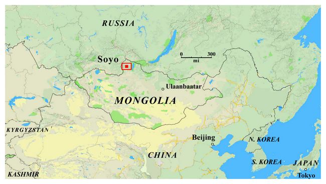
The primary Soyo archaeological site is an extensive stratified deposit rich in domestic artifacts, located in partially and periodically stabilized sand dunes on a low terrace on the south side of the Hogiin Gol (river) directly north and east of Soyo Tolgoi (hill) (figs. 1,2). The site represents the transition from an
 exclusively
hunting-gathering-fishing economy to one that included domesticated
animals (sheep, goats, cows, horses, yaks, camels)
exclusively
hunting-gathering-fishing economy to one that included domesticated
animals (sheep, goats, cows, horses, yaks, camels) Fig.1: Map of Mongolia showing location of Soyo archaeological site.
Our current understanding of this shift suggest that it initially took place between 6,000 and 4,000 years ago with a dramatic shift taking place roughly 3,000 years ago at the start of the Late Bronze Age. While it appears that Early Bronze Age (5,000 years ago) populations may have known about, had access to, and experimented with domesticated animals, dramatic shifts in settlement patterning and ritual expression in the Late Bronze Age may be reflective of other kinds of shifts (economic, political,social).
Previous Work in the Region
The site was discovered in 2003 by Dr. J. Bayarsaikhan and Dr. William Fitzhugh in a survey for Late Bronze age incised stelae known as Deer Stones.(see report for Mongolian-American Deerstone Project, available online through the Arctic Studies Center at the Smithsonian Institution).
In three previous field seasons by the NMAP, a total of 10 km2 was surveyed. In the 2016 field season the area within the base camp was surveyed using various test pits of 50x50cm along a northern tangent interspersed by 10m.
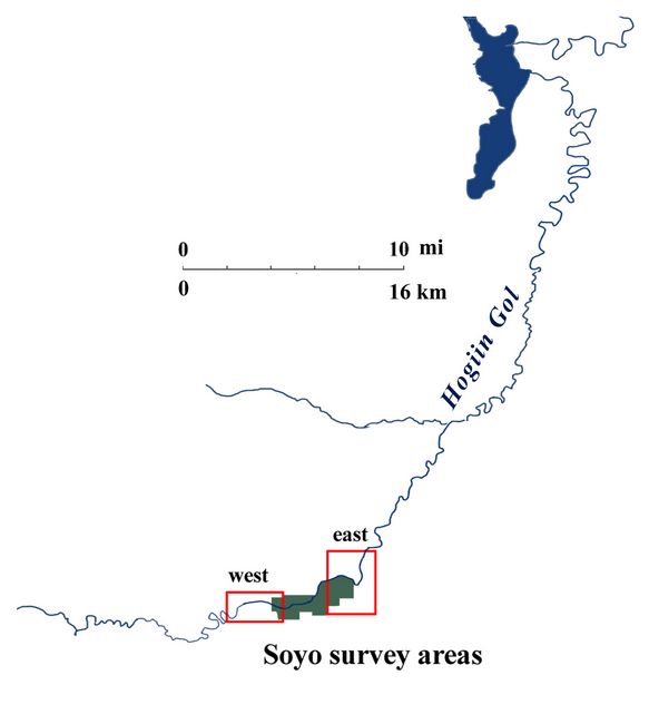
Fig.2: Location of Soyo survey areas along the Hogiin Gol.
2017 Funded Research Project (RFF-2017-46)
Goals:
The 2017 field season is the fourth consecutive summer research program at the Soyo site by NMAP. The main aims of this project are to explore the adaptations of the region’s ancient people at the transition from an exclusively hunting-gathering-fishing economy to one that included domesticated animals. In addition to the domestic activity at the site, the base and sides of Soyo Tolgoi are rich in ritual and burial features. The 2017 field season primarily focused on nearby sites and their relationship to the central Soyo site. In particular, the Bagsagiin Bulan site was the focus of much of the excavation and survey efforts of both ritual and habitation features.
Methodology and Findings:
The 2017 field season of the international interdisciplinary Northern Mongolia Archaeology Project (NMAP) took place between July 1st and July 22nd, 2017. Survey methods in 2017 included magnetometry survey, pedestrian survey, drone survey with digital photography, and surface artifact plotting using GPS and a total station. Excavation included horizontal exposure of features with full photo documentatio
 n
of excavation phases, total station recording of artifacts and
stratigraphic levels, and artifact and organic recovery using both dry
screening and flotation. Geomorphological testing ws also
performed. The NMAP project also collaborated with the National
Museum of Mongolia in their excavation and study of burials, and in
their study of Deer Stones.
n
of excavation phases, total station recording of artifacts and
stratigraphic levels, and artifact and organic recovery using both dry
screening and flotation. Geomorphological testing ws also
performed. The NMAP project also collaborated with the National
Museum of Mongolia in their excavation and study of burials, and in
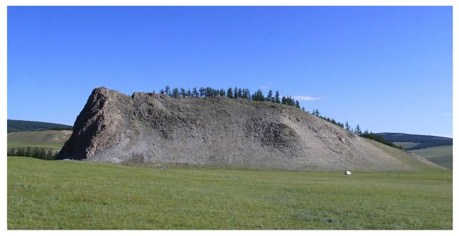
their study of Deer Stones.Fig.3: View of the hill at Soyo Tolgai from the south.
Magnetometry survey
During the 2017 field season at Soyo a magnetometry survey was conducted in order to determine the location of buried metal artefacts. A Bartington Magnetic Gradiometer 601 single sensor was used to conduct the survey over both the Soyo and BB1 sites. 20 by 20 meter sized grids were set up over the two sites and GPS points were taken for each corner of the grids.
Pedestrian Survey
During the 2017 field season, an additional 3.61 square kilometers were surveyed using systematic 20 m spaced transects. With the roughly 10 square kilometers from previous field seasons, the total systematically surveyed zone around Soyo Tolgoi is now 13.5 square kilometers. During this pedestrian survey, features are photographed, described, and their location logged with a handheld GPS and the GeoODK app.
 Bones from the surface were not collected, as it is not
possible to determine which surface bones are relative to our study and
which are modern. The primary artifact classes recovered during survey
were lithics, ceramics, and metal artifacts. Lithics recovered during
survey range from debitage and shatter – the byproducts of tool
production, to more formal tools such as projectile points, thumb
scrapers and retouched microblades.
Bones from the surface were not collected, as it is not
possible to determine which surface bones are relative to our study and
which are modern. The primary artifact classes recovered during survey
were lithics, ceramics, and metal artifacts. Lithics recovered during
survey range from debitage and shatter – the byproducts of tool
production, to more formal tools such as projectile points, thumb
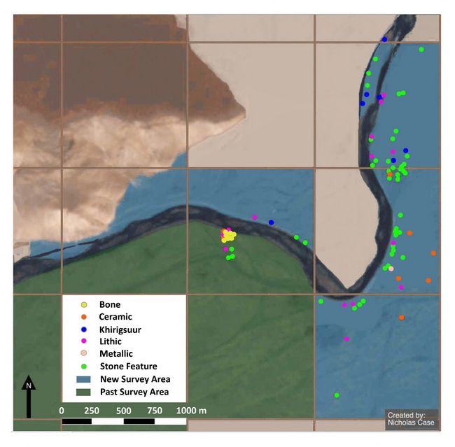
scrapers and retouched microblades.Fig.4: Map showing east survey area and locations of artifacts.
In addition to the above extensive survey, a more intensive survey of the surface artifacts at the Soyo Site and at the Bagsagiin Bulan site was conducted. At each site a 20 x 20 m grid was built, and then in each 20 x 20 m square, artifacts were flagged, mapped and collected. Additionally, an extensive lithic scatter on the north side of the river at the Soyo ford was rigorously and carefully recorded and mapped by Dr. Andrea Picin and Nils Vanwezer using the total station.
Drone survey:
Two drones, a DJI Phantom 3 and a 3DR Solo, were used to perform aerial surveys of parts of the Soyo and Bagsagiin Bulan sites and the surrounding areas. The drones were flown at altitudes between 0 and 150 meters, and were used to take aerial pictures at excavation sites at various stages of excavation. These will be used to construct three dimensional models of the sites using photogrammetry.
Photographs were also taken over approximately four square kilometers of the region surrounding the sites, which will be used to construct three dimensional models of the topography and features of the area. Additionally, photographs of the same four square kilometers were taken in near-infrared wavelengths. These will be used to create maps of the Normalized Differential Vegetation Index (NDVI), an indicator of vegetation robustness and health. Finally, aerial videos were collected at approximately 15 locations, including Soyo, Bagsagiin Bulan, surrounding areas, and looted graves in the area. These videos will be used for site overviews, marketing the project, and public education campaigns.
Excavations:
Bagsagiin Bulan Domestic Structure:
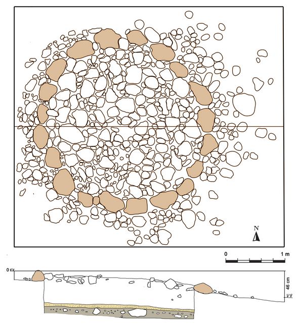
At Bagsagiin Bulan (N 51.0146, E 99.2183) we conducted excavations of a circular stone structure eroding out of the riverbank. At the time of discovery, the northernmost half of the structure was destroyed and had already washed down the slope, along with a variety of stone tools, pieces of ceramic, and bone fragments. All artifacts were plotted and collected using a precision GPS and professional survey equipment (Total Station), which showed that these artifacts were concentrated in the bottom of a small depression leading towards the river from the eroding bank.
 We
excavated a 5m x 5m grid around the feature to a level depth of 40cm
below the surface height in the SW corner, which revealed that the
structure was sitting on an ancient soil or “paleosol” – a dark organic
layer indicative of surface stability sometime in the past. The
structure consists of a shallow central pit filled wOverall, the 2017
season went very well and we are pleased with our results as we believe
that they will greatly improve our capacity to address our primary
research questions. Looking ahead, we plan to return to the region in
2018 employing our multi-disciplinary approach to this research. During
the 2017 field season we observed many looted graves and had many
conversations about this problem and hope to do a better job of
addressing this problem in future field seasons.ith large stones,
probably used as a hearth or fire pit. A second, outer ring of
structural stones were set into the ground at an approximate 45 degree
angle, and probably served as a foundation or wall supports (fig.5).
We
excavated a 5m x 5m grid around the feature to a level depth of 40cm
below the surface height in the SW corner, which revealed that the
structure was sitting on an ancient soil or “paleosol” – a dark organic
layer indicative of surface stability sometime in the past. The
structure consists of a shallow central pit filled wOverall, the 2017
season went very well and we are pleased with our results as we believe
that they will greatly improve our capacity to address our primary
research questions. Looking ahead, we plan to return to the region in
2018 employing our multi-disciplinary approach to this research. During
the 2017 field season we observed many looted graves and had many
conversations about this problem and hope to do a better job of
addressing this problem in future field seasons.ith large stones,
probably used as a hearth or fire pit. A second, outer ring of
structural stones were set into the ground at an approximate 45 degree
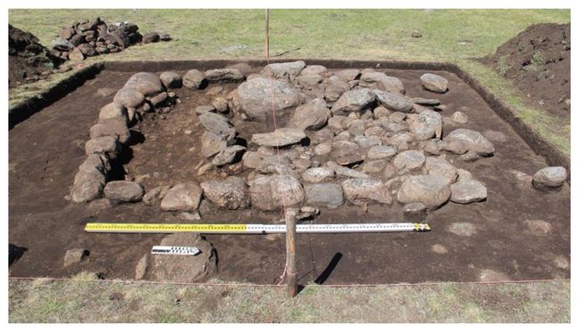
angle, and probably served as a foundation or wall supports (fig.5). Fig.5: (top:) Bagsagiin Bulan Domestic Structure after backfilling, with Soyo hill in the background. (bottom:) Digitally enhanced image of the Domestic Structure.
In the west corner of the feature, we discovered a large post hole 14 cm in diameter and reaching 13 cm below the surface, at a distance of approximately 50 cm from the edge of the structural stones. Although no similar holes were preserved in other areas of the structure, this hole probably once supported a structural timber. A smaller post hole of unknown purposes was discovered a short distance away.
All sediment from the site were screened with a 1/16” mesh (3 mm) to ensure recovery of small artifacts and bones. The site yielded a large number of ceramic artifacts and charcoal, along with a few fragments of animal bone and many microblades and other stone tools, which clearly indicate that the structure was used as a residence. Flotation was also employed. In total, we sifted and floated 170L of sediment from Bagsagiin Bulan, using buckets in conjunction with nested 1mm and 0.355 mesh geologic screens, collection 17 separate samples of organic material for archaeobotanical study.
Bagsagiin Bulan is the first well-documented habitation structure of its kind known for the early periods of Mongolian history. Based on the ceramic artifacts found at the site, it appears to date to the late Bronze Age (ca 1000 BCE). However, the site produced mostly small stone tools, which could suggested that it belongs to the early 2nd millennium BCE or earlier – a time period which probably witnessed the first emergence of mobile nomadic societies in Mongolia. The artifacts recovered from this site may provide unique and new information on the question of how societies made the transition from hunting to herding based subsistence.
Geomorphological testing:
One of the most important activities undertaken at Bagsagiin Bulan was the geomorphological characterization of the site, which reveals when and how the landforms underlying the site formed, and how the site has changed since the original structure was built. Dr. Jessie Thompson of the Colorado
School of Mines/University of Texas-El Paso excavated 5 small (50cm x 50 cm) geologic test pits – 4 in a transect perpendicular to the river, and one between the transect and the primary excavation.
The stratigraphy observed through these test pits indicates that Bagsagiin Bulan sits on a massive alluvial sand deposit (more than 70 cm in many places) underlain by glacial boulders deposited after the last glacial maximum (or around 15,000 years ago). The surface of this sandy deposit was stable for long enough to form a dark paleosol, the surface on which the structure was built. This layer is still the modern surface in most areas, but Bagsagiin Bulan was luckily buried by a large windblown sand deposit which preserved the site (and which is now eroding away). This excavation will help to identify other similar structures which were not buried, and thus have been exposed to thousands of years of trampling and damage by animals and weather. These structures are typically described as “ritual sites” and have not been identified as habitation sites by archaeologists.
Bayanii am 1: site on second terrace (elev. 1620m)
During a walk/survey on the northern side of the river in front of the base camp lithic material was found on the road and water runoffs. The artefacts were exposed due to the erosion provoked by the passage of cars, bikes and horses and rain water. Systematic survey of the area revealed that the
artefacts scatter covered roughly 40m of the second terrace of the river, with a few also on the first.
Over 360 artefacts were recovered. In order to understand the site formation processes and the depth at which the artifacts may have come from, a test pit was made in a 50x50cm grid on the second terrace in an area between many finds. During sieving of the top soil many bone and lithic pieces were recovered. Excavation extended to a depth of 64cm, with lower levels yielding no artefacts. The initial test pit was expanded to 2x2m in the north eastern direction in order to collect more bones for radiocarbon dating, ZooMS and other zooarchaeological analyses. Further expansion of the test pit revealed a large number of lithic artefacts (n=1096), charcoal (n= 17) and faunal material (n=424). Due to time constraints only three squares were completed and G6 was only partially excavated.
Bayanii am 3: lithic scatter
After looking for the dated glacial boulders of Högiyn Gol (51°00.380’N, 99°’47.994’E), dated to MIS 6 in Gillespie et al (2008), further terraces to the North West of Soyo base camp were investigated for pre LGM cultural material. One terrace (BA3) was found with 4 lithic materials made of quartz, two of which were simple unipolar flake cores, one core edge removal and one scraper fragment. These were recovered and their positions were recorded with a GPS.
Burial Excavations and Study
The Mongolian team from the National Museum of Mongolia, with whom NMAP collaborates, is primarily interested in the burials of the region.
 During the summer of 2017, they excavated 3 burials, which in spite of much modern looting, appeared undisturbed. However, the paucity of
material present in them suggests that perhaps they had been looted in
the past, which combined with taphonomic processes resulted in poor
preservation of the human remains.
During the summer of 2017, they excavated 3 burials, which in spite of much modern looting, appeared undisturbed. However, the paucity of
material present in them suggests that perhaps they had been looted in
the past, which combined with taphonomic processes resulted in poor
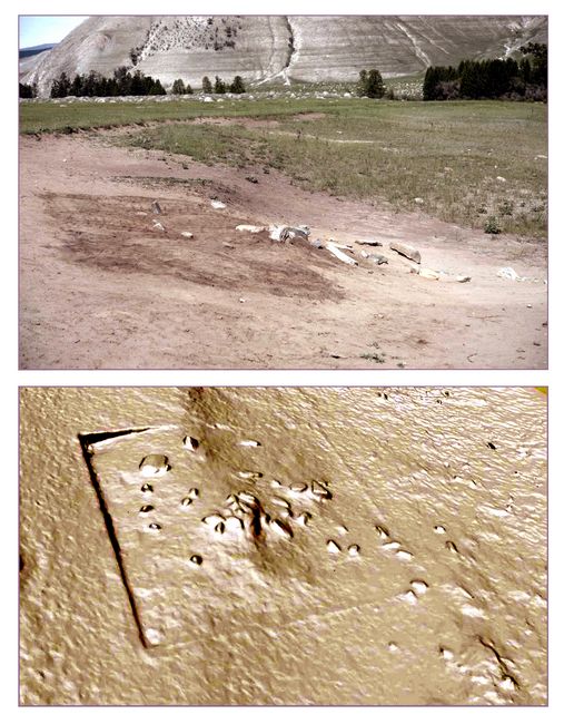
preservation of the human remains. The first burial was located 4.5 km to the east down the Khogin gol river from Soyo hill on the south side of the river, at an elevation of 1601 meters above sea level (fig. 6).
.
Fig.6: Drawing of Burial 1. showing plan view and section.
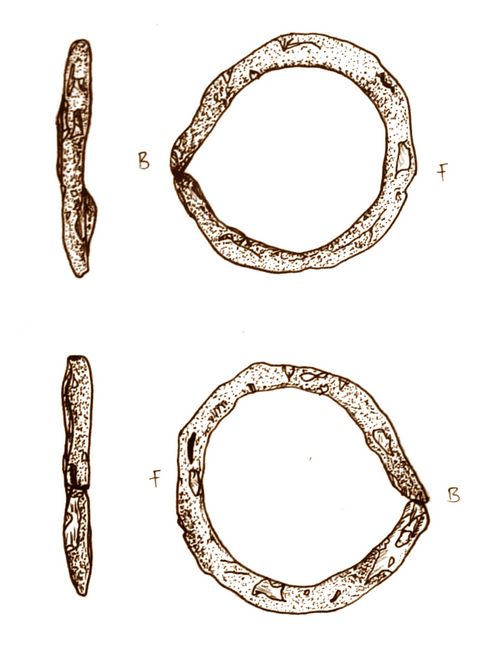
Burial 2 (fig.7) was located 4.7 km downstream from Soyo hill along the Khog River, and 200 m from
 burial 1 at an elevation of 1603 meters
above sea level. It contained various lithic artifacts as well as a bronze ring (fig.8)
burial 1 at an elevation of 1603 meters
above sea level. It contained various lithic artifacts as well as a bronze ring (fig.8)Fig.7 (right): Photo of Burial 2.
.
.
Fig.8 (left): Drawing of Bronze ring found in Burial 2 (Victoria Pham).
Burial 3 was located along the southern slope of Soyo Hill at an elevation of 1652 meters above sea level.
Deer Stone Studies:
In addition to an interest in burials, the Monglolian portion of the team was interested in pursuing Deer Stone (carved standing stelae common in Mongolia from the Late Bronze Age) research, of which Dr. Bayarsaikhan is a leading expert. Several new deerstones were discovered and recorded during the summer of 2017. One new deerstone was found at Bagsagiin Bulan, at an elevation of 1611 meters above sea level.
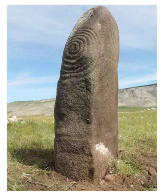 Another
Deer Stone was found in a place called Shuuregtei next to a large
khirigsuur or stone circle. This one was nearly completely buried, but Dr. Bayarsaikhan
identified one corner, excavated it, and turned it right side up. This contained a rare spiral form on one face (fig.9).
Another
Deer Stone was found in a place called Shuuregtei next to a large
khirigsuur or stone circle. This one was nearly completely buried, but Dr. Bayarsaikhan
identified one corner, excavated it, and turned it right side up. This contained a rare spiral form on one face (fig.9).Fig.9: Photo of Deerstone with spiral design found at Shuuregtei.
Artifact Cataloging and Curation:
All artifacts collected during this field season have been cataloged, photographed, and curated permanently at the National Museum of Mongolia alongside the artifacts from this site that were collected in previous field seasons. Additional analyses continues to be conducted on the artifacts from the work space at the National Museum of Mongolia. A complete digital catalog of all recorded sites and collected artifacts is attached as Appendix 3 to this report. The most impressive artifacts found may be accessed into the museum’s official collections and may be used for research or display at the National Museum of Mongolia.
Ethnographic and Ethnoarchaeological interviews:
During the summer field work of 2017, the NMAP team also conducted a series of ethnographic and ethnoarchaeological interviews. The purpose of these interviews is several-fold, and many topics are covered. For the members of the team new to Mongolia, it provides an opportunity to interact with local herders and understand their way of life better. Nearly always, herders welcome us into their home as it is an honor to host guests, and we return the favor by sharing news, and presenting small gifts. After the usual conversational niceties are shared, the team sought to understand plant use by local herders. Additionally, based on the interest of several medically trained personnel on staff, the relationship between traditional medicinal plants, shamanism, and disease, epilepsy in particular, was discussed. Understand plants from the local perspective will help us to make sense of the drone gathered NDVI data and its implications on the ground for those living there. There is a lot more to learn about plant use in the region, and this line of research will likely continue in future field seasons.
Conclusion:
Overall, the 2017 season went very well and we are pleased with our results as we believe that they will greatly improve our capacity to address our primary research questions. Looking ahead, we plan to return to the region in 2018 employing our multi-disciplinary approach to this research. During the 2017 field season we observed many looted graves and had many conversations about this problem and hope to do a better job of addressing this problem in future field seasons.
Recent Foundation grants: general Archaeology Grants Program w/map
Copyright © 2018 Rust Family Foundation