Rust Family Foundation: Archaeology Grants Program
Geoarchaeology
of the Connley Caves (35LK50) a Clovis Era Western Stemmed Tradition
Site in the Fort Rock Basin of South-Central Oregon
Principal Investigator: Dennis L. Jenkins
Museum of Natural and Cultural History, University of Oregon
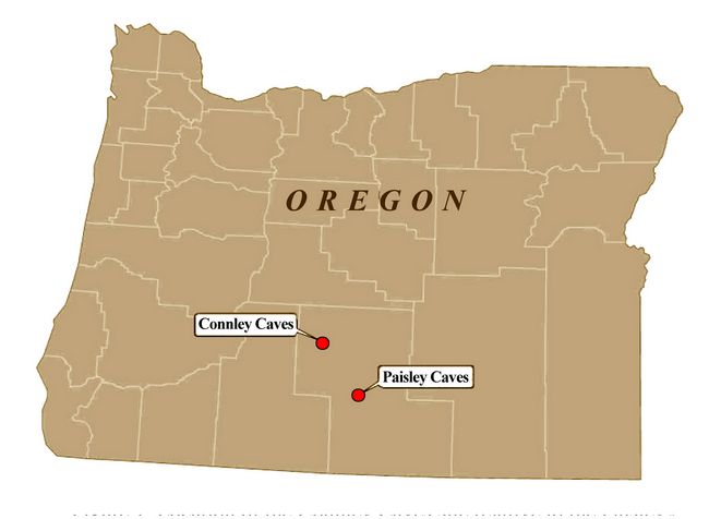
The Connley Caves (35LK50) in the Fort Rock basin of south-central Oregon (fig.1) contain deeply buried and stratified Terminal Pleistocene/early Holocene (TP/EH) cultural deposits of the Western S
 temmed Tradition.
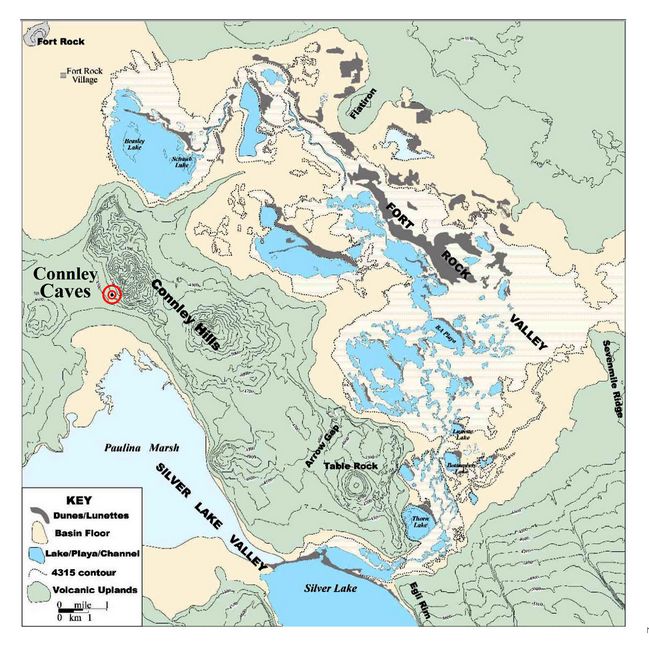
The site is composed of eight rockshelters and caves wave-cut into a
south-facing ridge of Miocene welded tuff, rhyolite and basalt by
pluvial Fort Rock Lake (Allison 1979). At a mean elevation of 1356 m
(4450 feet) the site is located in a juniper woodland on the lower
flanks of the Connley Hills some two kilometers north of Paulina Marsh
in the Silver Lake subbasin (fig.2).
temmed Tradition.
The site is composed of eight rockshelters and caves wave-cut into a
south-facing ridge of Miocene welded tuff, rhyolite and basalt by
pluvial Fort Rock Lake (Allison 1979). At a mean elevation of 1356 m
(4450 feet) the site is located in a juniper woodland on the lower
flanks of the Connley Hills some two kilometers north of Paulina Marsh
in the Silver Lake subbasin (fig.2). Fig.1: Location of the Connley Caves site relative to the Paisley Caves in Lake County, Oregon.
Surrounded at times during the TP/EH by shallow lakes and marshes, the Connley Caves are best known as the central locality from which Stephen Bedwell developed the concept of the ‘Western Pluvial Lakes Tradition’ (WPLT) (Bedwell
 1970, 1973), later expanded by Hester
(1973) to explain TP/EH settlement- subsistence patterns common
throughout the Desert West. Bedwell (1970) suggested that the
ecological situation reflected a primary subsistence focus during the
TP/EH on lacustrine resources, such as fish and waterfowl, and
terrestrial animals occupying grasslands surrounding shallow,
warm-water lakes and marshes.
1970, 1973), later expanded by Hester
(1973) to explain TP/EH settlement- subsistence patterns common
throughout the Desert West. Bedwell (1970) suggested that the
ecological situation reflected a primary subsistence focus during the
TP/EH on lacustrine resources, such as fish and waterfowl, and
terrestrial animals occupying grasslands surrounding shallow,
warm-water lakes and marshes.Fig.2: Location of the Connley Caves in the Fort Rock Basin.
However, studies have since shown that the Western Pluvial Lakes Tradition, as a foundational concept, draws too much attention to lacustrine resources and does not adequately account for sites often found in ecologically divergent settings. Consequently, it has gradually been replaced by the “Western Stemmed Tradition” (WST) which emphasizes shared technology sans the controversial ecological- subsistence constraints of the WPLT (Willig and Aikens 1988:28; Jenkins et al. 2016).
Previous research at the site:
Bedwell's excavations (1967-68)
Stephen Bedwell (1970, 1973) excavated in Connley Caves 1-6 in 1967 and Caves 4 and 5 in 1968. Bedwell’s excavations resulted in 21 radiocarbon dates ranging in age from 3080 to 11,200 BP. These dates were obtained from charcoal concentrations surrounded by artifact scatters. Each carbon sample was composed of ~5 grams of unidentified charcoal fragments where sample mixing was sometimes apparent.
Bedwell's excavations were conducted hastily and in a fashion inadequate to the task of identifying mixing of natural and cultural deposits. While the site was occupied to varying degrees during the middle and late Holocene, deposits above the 7600 cal. BP Mount Mazama tephra lens were often disturbed by vandals prior to Bedwell’s investigations. Bedwell began dating just below the Mount Mazama tephra without recognizing disturbed contexts and mixed scattered charcoal fragments of varying age to obtain standard radiocarbon dates. His radiocarbon dates for Lithic Unit 3, the stratigraphic levels associated with the Western Stemmed Tradition, span nearly 4500 years between 7900 and 11,200 BP.
Stratum 4, a thick, brown, silt deposit near the bottom of the stratigraphic sequence, was dated between 4720 and 11,200 BP. Both of the latter dates were recovered out of stratigraphic sequence. The 11,200 BP sample was recovered 60 cm above a younger sample dated at 10,600 BP. The evidence for disturbance in the deposits and Bedwell’s problems with stratigraphically inverted radiocarbon dates cast doubt on the integrity and age of the cultural deposits. This seriously depreciated the research value of the site to most Paleoindian archaeologists in the American West.
2000-2001 Investigations:
More careful and informed investigations were clearly necessary to make sense of the Western Stemmed Tradition record at the Connley Caves. The University of Oregon field school began new excavations at the Connley Caves in 2000-2001. These were resumed between 2014 and 2017 and resulted in finding undisturbed deposits in caves 5 and 6.
Project goals:
Goals of the field school were to: 1) reassess the geochronology of the earliest cultural deposits, seeking possible evidence for 11,000 BP occupations at the site, and possibly even older occupations such as at the Paisley Caves (12,000 BP); 2) investigate the function of the large stone tool assemblages in them; and 3) cast new light on subsistence choices made by WST populations at the Connley Caves.
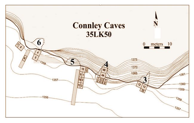
Fig.3: Map of Connley Caves excavations.
Test units placed near Bedwell’s excavations at the mouth of caves 5, and 6 (fig.3) recovered large numbers of scrapers and edge-modified flakes in association with Haskett type projectile points. A shallow rockshelter between caves 4 and 5 contained undisturbed, dry, middle Holocene deposits containing perishable cultural materials such as basketry, cordage, human and animal coprolites, bone, feathers, and wads of grass, bulrush, and sagebrush bark.
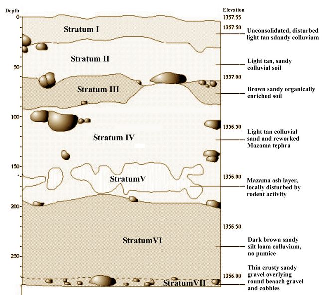
Altogether, the 2000-2001 excavations identified seven primary strata in both caves 5 and 6 (fig.4). The upper four strata are colluvium composed of angular pinkish-brown volcanic tuffs,
 a smaller quantity of dark gray
fine-grained basalt eroding out of the cliff face, and varying mixes of
cultural debris most likely ejected from the interior of the caves.
Stratum I was dated by a single shell bead date at 770 ± 40 BP,
Stratum III by eight 14C samples ranging in age between 1970 ±
40 BP and 4930 ± 70 BP, and Stratum IV by four samples
ranging in age from 7810 ± 40 BP to 9430 ± 80 BP.
a smaller quantity of dark gray
fine-grained basalt eroding out of the cliff face, and varying mixes of
cultural debris most likely ejected from the interior of the caves.
Stratum I was dated by a single shell bead date at 770 ± 40 BP,
Stratum III by eight 14C samples ranging in age between 1970 ±
40 BP and 4930 ± 70 BP, and Stratum IV by four samples
ranging in age from 7810 ± 40 BP to 9430 ± 80 BP.Fig.4: Primary strata of caves (after Beck et al. 2004).
Underlying these, Stratum V was a dense white primary air fall of Mount Mazama tephra, up to 20 centimeters thick, which has been most accurately dated in the local region at the Paisley Caves to 6790 ± 15 BP (Jenkins et al. 2012). Below it, Stratum VI is a brown sandy-silt aeolian-colluvium mix 100-140 cm thick which contains the Western Stemmed Tradition cultural deposits. At the bottom of the stratigraphic sequence, Stratum VII is a well sorted, high energy beach deposit of water-worn cobbles, boulders, sands and gravels overlying bedrock (Beck et al. 2004).
2014-2015 Investigations:
Work by the University of Oregon field school resumed at the site in 2014. Excavations at Cave 4 involved a 2x4m excavation block (fig.3) oriented along an east-west axis, abutting the south wall of Be
 dwell’s Unit 4A. At the base
was lithostratigraphic unit (LU) 1, the Pleistocene beach deposit some
300 centimeters below the modern surface previously identified as
Stratum VII in Cave 5. LU2, abruptly overlying LU1, is a 25 cm
thick, compact, orange-brown silty sediment containing up to 30%
water-worn gravels. This unit may correlate with the culturally sterile
“crusty” beach sand overlying Stratum VII in caves 5 and 6.
dwell’s Unit 4A. At the base
was lithostratigraphic unit (LU) 1, the Pleistocene beach deposit some
300 centimeters below the modern surface previously identified as
Stratum VII in Cave 5. LU2, abruptly overlying LU1, is a 25 cm
thick, compact, orange-brown silty sediment containing up to 30%
water-worn gravels. This unit may correlate with the culturally sterile
“crusty” beach sand overlying Stratum VII in caves 5 and 6.
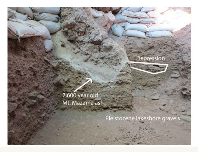
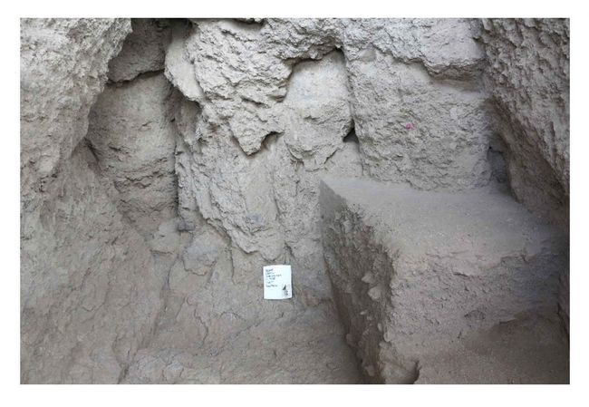
Fig.5: Intrusive Mt. Mazama ash below large roof-fallen rock.
Lithostratigraphic Unit 3 (LU3), the dark brown silty aeolian-colluvium mix deposit containing Western Stemmed Tradition cultural components, is sandwiched between LU2 and the Mt. Mazama 6790 BP tephra lens (LU4).
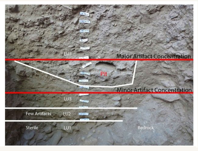 Dense concentrations of artifacts were
encountered along the east side of Cave 4. Cultural deposits in LU3 dip
down toward the west where alluvial silt lenses filled a 20 cm deep pit
apparently dug by the ancient inhabitants, as suggested by the fact
that the lip of the pit correlates with a major horizontal
concentration of artifacts (fig.6).
Dense concentrations of artifacts were
encountered along the east side of Cave 4. Cultural deposits in LU3 dip
down toward the west where alluvial silt lenses filled a 20 cm deep pit
apparently dug by the ancient inhabitants, as suggested by the fact
that the lip of the pit correlates with a major horizontal
concentration of artifacts (fig.6). Fig.6: West wall of Unit 4/1 showing strata LU1-LU3, artifact concentrations, and pit feature.
Ten single fragment, species-identified charcoal samples recovered in situ from LU2 and LU3 were 14C dated by the AMS method. These were identified as Artemisia (n=7), Pinus (n=2), and Salix (n=1). They produced dates ranging from 8833 ± 44 BP to 11,080 ± 40 BP. Five dates clustered around 10,400 BP and four dates between 10,770 and 11,080 BP (fig.7). The two youngest LU2 dates (8833 and 10,234 BP), are out of stratigraphic sequence. LU2 is dated by three internally
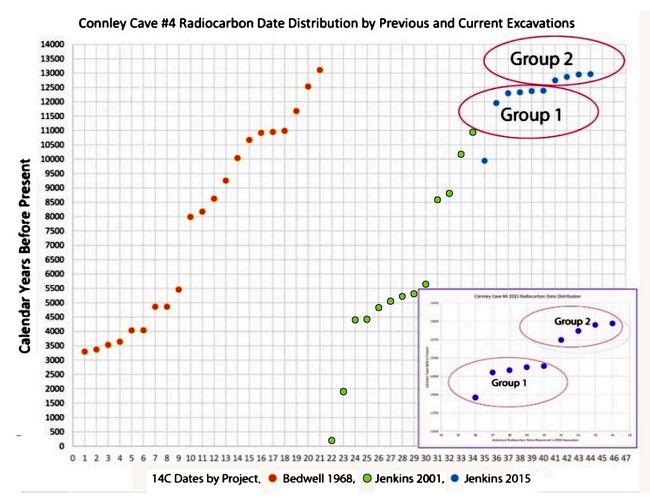 consistent
samples ranging from 10,769 ± 43 BP to 11,062 ± 40.
Similarly out of geochronological sequence is a single sample dated at
11,080 ± 42 which was recovered too high in the deposits
of LU3 where the remaining four internally consistent dates range from
10,371 ± 43 BP to 10,455 ± 39 BP. All projectile points from these deposits are WST series Haskett points (Fig.8).
consistent
samples ranging from 10,769 ± 43 BP to 11,062 ± 40.
Similarly out of geochronological sequence is a single sample dated at
11,080 ± 42 which was recovered too high in the deposits
of LU3 where the remaining four internally consistent dates range from
10,371 ± 43 BP to 10,455 ± 39 BP. All projectile points from these deposits are WST series Haskett points (Fig.8). Fig.7: Graph of 2015 radiocarbon dates.
2016-2017 Investigations:
The 2016 investigations of Cave 4 were designed to investigate cultural deposits that could possibly remain in the cave below Bedwell’s excavations. This required the removal of a massive qua
 ntity of
redeposited spoil dirt from Bedwell’s 1967-68 excavations. These
deposits were generally 200-220 cm in depth. Just beneath the disturbed
LU3 deposits, three Haskett points (one complete and two bases) were
encountered in the first controlled five centimeter level
excavated. Other artifacts recovered from these deposits include
four bone needle fragments, a few scrapers and edge-modified flakes, and biface fragments.
ntity of
redeposited spoil dirt from Bedwell’s 1967-68 excavations. These
deposits were generally 200-220 cm in depth. Just beneath the disturbed
LU3 deposits, three Haskett points (one complete and two bases) were
encountered in the first controlled five centimeter level
excavated. Other artifacts recovered from these deposits include
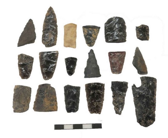
four bone needle fragments, a few scrapers and edge-modified flakes, and biface fragments.Fig.8: Haskett projectile point fragments showing variability in size and basal morphologies.
Results of Funded Project (RFF-2017-44):
The 2017 excavations revealed that all deposits in the rear half of Cave 4 had been thoroughly disturbed to bedrock (Fig.9). We left one 1 m x 2 m block unexcavated in the northeast corner of the cave as a ‘testimony block’ for possible future investigations, and removed the rest of deposits within the cave. We verified that all cultural deposits are most likely associated with LU3. Flakes and charcoal found in LU2, the oxidized gravelly silt separating the silty cultural deposits of LU3 from the water-rounded cobbles and gravels of LU1, appear size sorted (small to tiny) and likely originated with LU3.
 We obtained another seven radiocarbon
dates on single pieces of identified charcoal (5 sagebrush, 1 pine, 1
willow). Similar to previously obtained dates, these samples dated
between 10,149±48 BP and 11,104±45 BP, again indicating a
brief first occupation around the time of Clovis followed by intensive
occupations during the late Younger Dryas.
We obtained another seven radiocarbon
dates on single pieces of identified charcoal (5 sagebrush, 1 pine, 1
willow). Similar to previously obtained dates, these samples dated
between 10,149±48 BP and 11,104±45 BP, again indicating a
brief first occupation around the time of Clovis followed by intensive
occupations during the late Younger Dryas.Fig.9: Completed excavation at back of Cave 4, 2017.
Excavations in Cave 5 investigated an undisturbed overhang area which recovered basketry, cordage, bone, charcoal, coprolites, hide, and lithics. Cultural deposits reach depths between 300 and 350 cm. The 2017 excavations encountered several well-defined hearths surrounded by Cascade (serrated foliates) and Haskett projectile points, a first for this site. Radiocarbon dates for these features are 7770±44 BP, 8142±38 BP, 9171±40 BP, and 9183±48 BP. Previous excavations (2001) in these deposits reached bedrock at 400 cm and recovered radiocarbon dates of 7950±40 BP and 9430±80 BP.
We anticipate excavating cultural deposits in 2018 to about 350 cm. In the shallow rockshelter between caves 4 and 5 we plan to continue investigations to determine whether there might be cultural deposits older than 11,000 BP. The 2017 discovery of multiple hearths and high artifact density in this area suggest that it was a favorite location during the pre-Mt. Mazama period between 6790 BP and at least 9430 BP (Beck et al. 2004).
Conclusions:
Over the last three years we have carefully investigated site formation processes, dating levels with precisely identified charcoal samples from reliable contexts. We find that the earliest cultural deposits in Cave 4 span a period of roughly 1,000 radiocarbon years between 10,150 and 11,100 BP. Our sagebrush, pine, and willow samples indicate there were two predominant periods of occupation in LU3. The earliest occurred during the Clovis era between roughly 10,800 and 11,100 BP. The later occupation between 10,150 and 10,450 BP. Stratigraphic association and radiocarbon and obsidian hydration dating indicate Haskett points were prevalent during both phases of occupation. Cave 4 was likely too wet for occupation prior to ca. 11,100 BP.
Future work:
An estimated 80 cm of cultural deposits remain to be excavated during the summer of 2018. Projected 2018 excavations in Cave 5 will begin at the 9200 BP level and should reach the bottom of the shelter by summer’s end. Being presumably drier than Cave 4, Cave 5 may have been suitable for occupation at a date earlier than 11,000 BP. Thus, the 2018 University of Oregon field school excavations in Cave 5 could conceivably encounter deposits older than those in Cave 4.
References:
Allison, Ira S.
1979 Pluvial Fort Rock Lake, Lake County, Oregon. State of Oregon Department of Geology and Mineral Industries Special Paper 7. Portland.
Beck, Charlotte, George T. Jones, Dennis L. Jenkins, Craig E. Skinner, and Jennifer J. Thatcher
2004 "Fluted or Basally-Thinned? Re-Examination of a Lanceolate Point from the Connley Caves in the Fort Rock Basin." In Early and Middle Holocene Archaeology of the Northern Great Basin, edited by Dennis L. Jenkins, Thomas J. Connolly, and C. Melvin Aikens, pp. 281-294. University of Oregon Anthropological Papers 62. Eugene.
Bedwell, Stephen F.
1967 Field notes on file, Museum of Natural and Cultural History, University of Oregon, 1968 Eugene.
1970 Prehistory and Environment of the Pluvial Fort Rock Lake Area of Southcentral Oregon. Ph.D. Dissertation, Department of Anthropology, University of Oregon. Eugene.
1973 Fort Rock Basin: Prehistory and Environment. University of Oregon Books. Eugene.
Grayson, Donald K.
1979 Mt. Mazama, Climatic Change, and Fort Rock Archaeofauna. In Volcanic Activity and Human Ecology, P.D. Sheets and D.K. Grayson eds., pp. 427-458. Academic Press, New York.
1993 The Deserts Past: A Natural Prehistory of the Great Basin. Smithsonian Institution Press, Washington, D.C.
Hester, Thomas R.
1973 Chronological Ordering of Great Basin Prehistory. University of California Archaeological Research Facility Contributions 17. Berkeley.
Jenkins, Dennis L., Loren G. Davis, Thomas W. Stafford, Jr., Paula F. Campos, Bryan Hockett, George T. Jones, Linda Scott Cummings, Chad Yost, Thomas J. Connolly, Robert M. Yohe II, Summer C. Gibbons, Maanasa Raghavan, Morten Rasmussen, Johanna L. A. Paijmans, Michael Hofreiter, Brian M. Kemp, Jodi Lynn Barta, Cara Monroe, M. Thomas P. Gilbert, Eske Willerslev
2012 "Clovis Age Western Stemmed Projectile Points and Human Coprolites at the Paisley Caves." Science 337: 223-228.
Jenkins, Dennis L., Loren G. Davis, Thomas W. Stafford, Jr., Thomas J. Connolly, Michael Rondeau, Linda Scott Cummings, Bryan Hockett, Katelyn McDonough, Ian Luthe, Patrick W. O’Grady, Karl J. Reinhard, Mark E. Swisher, Frances White, Robert M. Yohe II, Chad Yost, Eske Willerslev)
2016 "Younger Dryas Archaeology and Human Experience at the Paisley Caves in the Northern Great Basin." In Stones, Bones, and Profiles: Archaeology and Geoarchaeology in Honor of C.V. Haynes, Jr. and George C. Frison, Marcel Kornfeld, Bruce B. Huckell, editors. The University Press of Colorado.
Jenkins, Dennis L., Michael S. Droz, and Thomas J. Connolly
2004 "Geoarchaology of Wetland Settings in the Fort Rock Basin, South-Central Oregon." In Early and Middle Holocene Archaeology of the Northern Great Basin, edited by Dennis L. Jenkins, Thomas J. Connolly, and C. Melvin Aikens, pp. 31-52. University of Oregon Anthropological Papers 62. Eugene.
Willig, Judith A. and C. Melvin Aikens
1988 "The Clovis-Archaic Interface in Far Western North America." In Early Human Occupation in Far western North America: The Clovis-Archaeic Interface, edited by Judith A. Willig, C. Melvin Aikens, and John L. Fagan, pp. 1-40. Nevada State Museum Anthropological Papers 21. Carson City.
Recent Foundation grants: general Archaeology Grants Program w/map
Copyright © 2018 Rust Family Foundation