Rust Family Foundation: Archaeology Grants Program
Royal City of Sais Project [Egypt]
Principal Investigator: Penelope Wilson, Senior Lecturer in Egyptian Archaeology, Department of Archaeology, University of Durham
Sais was the capital city of Egypt in the 7th
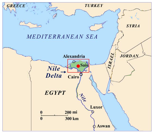 -6th century BC. Situated in
the western Nile Delta it was strategically a highly suitable place
from which to integrate Egypt into the Eastern Mediterranean and Aegean
trade networks, using the rest of Egypt as a powerful surplus-resource
base. The early stages of the city are under archaeological
investigation, charting the development of the city from a provincial
administrative centre around 1100 BC which was destroyed by seismic
activity, then rebuilt as a more robust city around 1000-900 BC, with
thick-walled
-6th century BC. Situated in
the western Nile Delta it was strategically a highly suitable place
from which to integrate Egypt into the Eastern Mediterranean and Aegean
trade networks, using the rest of Egypt as a powerful surplus-resource
base. The early stages of the city are under archaeological
investigation, charting the development of the city from a provincial
administrative centre around 1100 BC which was destroyed by seismic
activity, then rebuilt as a more robust city around 1000-900 BC, with
thick-walled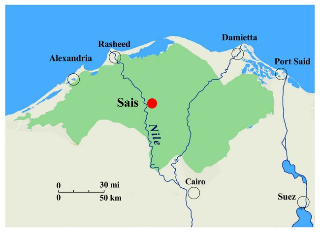 structures containing storage and domestic units, as well
as some industrialised areas. It was this town which became the
proto-capital of the Western delta. The project examines the built
environment and lifeways of the people, to determine the extent to
which they changed from administrative centre to proto-capital to
capital and, therefore, to understand how individual lives changed to
accommodate the increased political and economic power of the new
centre.
structures containing storage and domestic units, as well
as some industrialised areas. It was this town which became the
proto-capital of the Western delta. The project examines the built
environment and lifeways of the people, to determine the extent to
which they changed from administrative centre to proto-capital to
capital and, therefore, to understand how individual lives changed to
accommodate the increased political and economic power of the new
centre.Fig.1: Location of Sais in the western Nile Delta.
Previous research at the site:
The Durham University/Egypt Exploration Society/Ministry of Antiquities Mission at the site for the last 20 years has been recording the sub-surface archaeological remains and history of the Saite are. It is now known to have have been settled at least as early as the Neolith
 ic
period and was continuously settled into the modern era. Different
levels of the settlement areas have been excavated or surveyed in order
to follow the development of the town and understand the dynamics of
life in this one place over the last six thousand years.
ic
period and was continuously settled into the modern era. Different
levels of the settlement areas have been excavated or surveyed in order
to follow the development of the town and understand the dynamics of
life in this one place over the last six thousand years.Fig.2: Excavation of magazine site in 2017.
Project goals:
• to understand the way in which the built environment changed from a provincial town to a capital city;
• to understand the role played by a seismic event which destroyed the administrative centre. Was the proto-capital a reaction to this event, an example of ancient resilience in the face of disaster or a coincidental opportunity to restructure the urban and lived environment?
• to analyse the lifeways of the people in the successive towns by studying their pottery, food and built environment;
• to explore the vertical and horizontal extent of the ancient city zones and its relationship with the river and other features of the landscape;
• to provide training, discussion and experience for local Antiquities Inspectors in carrying out excavation and post-excavation work.
Results of Funded Project (RFF-2017-41):
Background
• The length of the excavation was planned to be from the beginning of August to the end of September,2017. We received our security clearance only at the beginning of August and then could plan for flights and logistical support. As a result we began work at the beginning of September and so could only spend 4 weeks in the field. We completed about half of the excavation work and analysis that we hoped for. The magnetic survey of the fields, a wider project goal, was able to proceed because of the beginning of the harvest and field clearance during September. This included a training programme for Egyptian Antiquities Inspectors and all of the students on the project.
• Specialists were able to come out to work in the field including Dr Clare Malleson (archaeobotanical analysis), Ms Esmeralda Lundius (Illustrator) and Dr Maria Cannata (magnetometry).
Methodologies and Findings:
Methodologies included excavation, post-excavation analysis of sediments, plant remains and animal bones, non-invasive magnetic mapping and geological work.
The main findings from 2017 work at Sais include:
• confirmation of a large scale seismic event visible as fissures across the site, at the level of the first floor surface of the Ramesside provincial city, exemplified by a large domestic structure and its storage magazine/food prcessing areas.
• confirmation of the date of the Ramesside area to Dynasty 20 (1189-1077 BC) by the find of a scarab with parallels in Upper Egypt.
• creation of a pottery typology, the first of this date from what will be the type-site f
 or the period in the north of Egypt.
• extensive sub-surface magnetic mapping of the city zones of the Saite period to the north and south.
Magnetic survey:
Twelve areas were surveyed in the area of Sais/Sa el Hagar including the whole of the base of the Great Pit. Sub-surface remains were detected in several areas including a dense area of structures between the two areas of Kom Rebwa (Area 2017.1). The elite Late Period cemetery at Kawady was also mapped showing several structures, limestone coffins and graves.
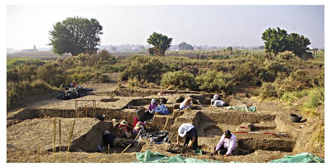
Fig.3: Plan of Excavation area. Areas excavated in 2017 (Ex. 12, 17, and 21) are heightened in red.
Excavation:
In the 2017 excavations (fig.3), important results included the discovery and confirmation of the presence of the seismic ‘fissure,’ Also confirmed is the fact that the magazine is a rather extensive building whose limits to the south are still undetermined. The remainder of the contents of the magazine are clearly still buried.
 Excavation Unit 12
Excavation Unit 12 (fig.4) is the unit containing the main magazine or storage and food processing area. In 2017 the floor layers were systematically and slowly excavated in order to establish the floor layer strata, to examine the different kinds of activity carried out in the magazine and, to some extent, to understand the length of time for which the magazine functioned.
The uppermost layer of the floor was the period of last use, sealed down by the collapsed roofing material and upon which pottery had been lying (excavated in 2012, 2014). Some structural features were also found, including mud surrounds for pot-stands or mud-bases for ovens and bowl-heaters.
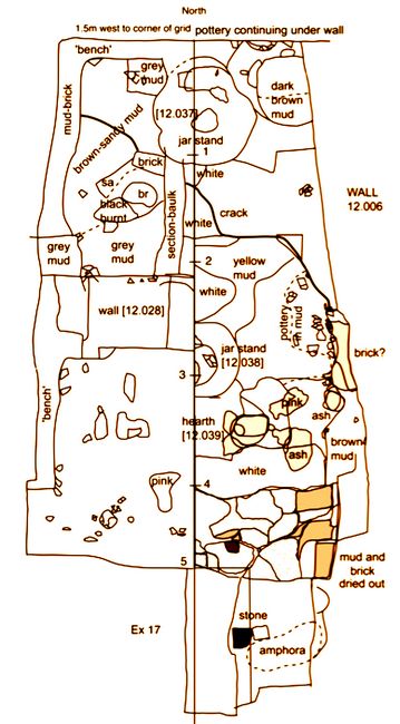
Fig.4: Plan of floor layers in Excavation Unit 12.
One of the main features exposed was a large amphora stand in the north part of the magazine. The stand may have functioned until the end of the magazine as the upper part of the pot-stand was prominent in the upper phases; there were signs of at least two other stands in the centre of the magazine and one ashy oven. A stand in the southern portion had been built over a small oven-heating feature. The jar stand had been constructed by pouring a layer of mud into the last bowl in the fireplace/heating feature and then a further mud surround was built over the small heater. The base of the stands correlated to the first phase of use of the magazine after its construction and then as the excavation proceeded down through the layers, the preparatory foundation and preceding strata were encountered.
Large amounts of broken pottery were recovered from the magazine and its foundation levels and as much material as possible was collected in order to establish the most common types used every day. They were small conical or round-base bowls, which were effectively disposable and once no longer needed when broken were thrown down onto the floor perhaps to add some strength to the floor layers. The rims varied between extremely fine and thin-walled bowls, perhaps small
 drinking
bowls to larger, more coarse and thicker walled bowls, perhaps for
serving or heating food.
drinking
bowls to larger, more coarse and thicker walled bowls, perhaps for
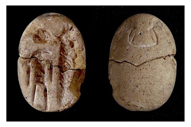
serving or heating food. The most significant find from the fill of the magazine was a scarab showing the god Thoth and a cultic emblem or maat-feather (SF 12.056, fig.5). It dates to Dynasty 20-21 and is paralleled by an example from Medinet Habu in the south of Egypt.
Fig.5: Faience scarab from Ex.12 (SF12.056), L. 1.65cm, W.1.1 cm, Th. 0.7 cm from [12.033]. It shows ibis-headed Thoth with lunar disk and crescent moon over his head (left), in front of a maat-feather (?) or tekhen-symbol (?) (right).
The most important structural find was located at the point where the first layers of the magazine floor intersected with the foundation levels. A ‘fissure’ ran across the magazine floor from east to west (fig.6). The early magazine floor levels to the south of the crack seemed to have slipped downward and been displaced. This was evidenced by white layers on the floor apparently having been split in two, tipping southward and lying at a slightly lower level than the white floor layers on the northern side of the crack.
The location of the fissure aligns with the fissure found in our earlier Excavation Unit 1 in the first layers of the house floor. The presence of the feature, running over such a long distance — at
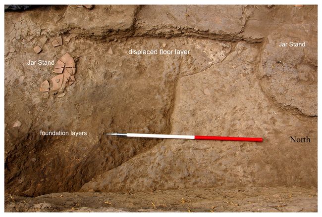 least 15m — may support the idea of an earth tremor or subsidence that
brought about the collapse of the magazine. More work is needed to
understand the effects and evidence for seismic activity in alluvial
environments, and to check whether there are any deeper sub-surface
features — such as structural voids or cavities — that may have caused
the collapse of the ground surface.
least 15m — may support the idea of an earth tremor or subsidence that
brought about the collapse of the magazine. More work is needed to
understand the effects and evidence for seismic activity in alluvial
environments, and to check whether there are any deeper sub-surface
features — such as structural voids or cavities — that may have caused
the collapse of the ground surface.Fig.6: Magazine first floor level in Ex.12, with fissure running east-west across it. Note the white displaced floor layer. The scale has 50 cm segments.
Excavation Unit 17
The area of Unit 17 lies to the south of the magazine and potentially the lower layers contain a continuation of the magazine southward. In the Upper City layers a series of small rooms were found including one square 1.5m by 1.5 m room with a white washed floor. The pottery from the rooms was indicative of a date in the Third Intermediate Period (1070-664 BC) and joined some of the other pottery found here in previous years. Beneath this level the collapsed magazine layers were reached, comprising dark brown mud fill, perhaps from collapsed mud-brick, which had been partially flattened to create a flat layer for the building of the upper s
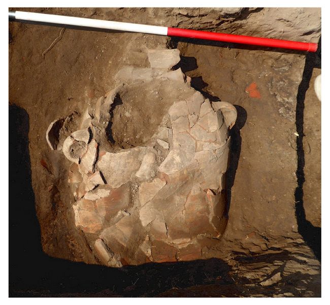 tructures.
 Within the collapsed rubble there was found a Nile silt, four-handled amphora, which was flattened and broken, but complete so that it was possible to reconstruct the jar (fig.7). The type was already known from the magazine contents found in Excavation 1. Its position, therefore, confirmed the last level of the magazine and also the fact that the magazine structure extended southward.
Fig.7: Four-handled jar (amphora) in situ in Ex.17, height ca. 83 cm, maximum diameter ca. 43 cm, rim diameter 22 cm. North to the right.
Excavation Unit 21
Work also continued in Unit 21 to the south-west of the magazine, where the floor levels of the domestic quarters were carefully removed. It had been assumed that the pile of pottery in the upper levels was connected either with the kiln production in the last phase of the Third Intermediate Period structure or with sebakhin digging (recent dirt removal from tells by farmers). The layers of the room nearest the eastern wall seemed to contain intact ancient archaeological features, but the layers on the western side of the trench towards the south-west corner seemed to consist of mixed and loose rubbish-filled soil that included some residual material such as a pottery cobra head, copper alloy rod or tool handle and an ivory stud or gaming piece.
This layer underneath the earlier pottery-filled dump seemed to confirm that the stratigraphy had been severely affected by the sebakhin digging and that they may have used the ancient walls as a place in which to live during the dismantling of the mud-brick layers. The layers at the base of the walls suggested that there were some additional structural features including a small line of mud-bricks at the wall base and extending out into the room. The floor layers comprised ashy deposits, mud and some fill, along with pottery jar and bowl fragments, some of which could be reconstructed.
Pottery
A large amount of pottery sherds kept in the EES/Durham Magazine was studied. Our Egpytian conservators began the reconstruction of the complete but broken jars and Esme Lundius finished all of the drawings of small finds ready to publication standard. The sherds were sorted according to the colour and type of fabric, their surface treatment, thickness of ware and any identifying features such as technical wheel marks, specific fabric types or burnt examples.
Several of the large amphorae were reconstructed in order to have a clear idea about the contents of the magazine. Those studied included: a red amphora with burning on the outside, a cylindrical amphora with an orange inside surface and cream outside surface, three ‘Tiger stripe’ jars, two jars with orange-cream slip on the outside, three small globular funnel-necked jars with burning on their bases, used for cooking, several small conical and round-based bowls, Levantine fabric vessels including Canaanite amphorae.
A number of residual sherds were also noted amongst the pottery material including Medum bowl fragments and red polished wares (Old Kingdom), bread moulds (First Intermediate Period to New Kingdom), a polished, fine Prehistoric sherd and distinctive bowls with red painted rims, which may date to the early New Kingdom, all relating to the deep underlying layers of the settlement.
Floral Analysis
The samples processed and studied this season all came from excavations in the Third Intermediate Period buildings, and contained assemblages of charred cereal crop processing by-products (cereal chaff, crop-weed seeds) from fireplaces and ovens in the settlement. A grape-pip was also found in one of the samples.
Conclusions:
The single-context excavation combined with the pottery recording and reconstruction and study of the small finds, enabled us to begin to establish the pottery typology and dating framework for the material. As Sais will be the type-site for this period, it is important to slowly record and reconstruct as much of the pottery as possible. The potential to reconstruct much of the last assemblage of the magazine before its collapse is being realised so that this one moment in time can be captured.
When the analysis of the floral and faunal material is completed in future seasons, the species identified in the analysis will be linked to the pottery jars and vessels. The information will be invaluable for understanding the types of foodstuffs stored and processed in the magazine/kitchen area, the diet of the Ramesside and Third Intermediate Period towns and the lifestyle of the people who lived in the city. Moreover, changes and similarities between the two towns will allow us to establish whether changes in diet and pottery forms can inform us about wider economic, social and political characteristics between the two periods, leading to the establishment of a power-base and ultimately, the capital city at Sais.
The scarab with the god Thoth can be paralleled to another from Medinet Habu of Dynasty 20-21 so is an important confirmation of the date of the magazine and also of the wider homogeneous material cuture of the Late New Kingdom.
Analysis of the fissure through discussions with seismic experts also suggest that some sort of earthquake led to the destruction of the Dynasty 20 city and implies that the whole of the area does preserve a complete city, as suspected. The rebuilding of the destroyed city may have ultimately led to the development of the proto-capital of Sais in the Third Intermediate Period and suggest that the destruction was an opportunity not a disaster for the city, suggesting that it is an ancient example of resilience and sustainability.
The magnetic survey suggests that it will be possible to map the entire sub-surface features of the site and explore specific areas in targeted future work, such as the cemetery, domestic and industrial areas as well as harbour and riverside facilities.
The site can make a significant contribution to understanding urban form(s), resilience and transformation in Egypt, specifically in the Delta. The period during which Egyptian power moved to the north of the country and to Sais can be documented and may be attributable as much as a response to a natural disaster as to the individual charisma of its rulers and to the strategic location and rich hinterland of the city of Sais.
The site also will provide a pottery typology for one of the main centres of power in the north and test the extent to which new forms emerged from old ones, or whether there was innovation based on ancient forms (archaism) or as a response to different cultural groups in the region or the necessity to create new storage forms or develop old ones because of new types of food supply.
Future work:
Ongoing Plans, final publication
The excavation and post-excavation work will continue in 2018 and into 2019.
• The main focus of the work is to find the limits of the Ramesside city magazine in order to understand the extent and scale of the storage facility. This may help to answer the question as to whether the area was part of the provincial administrative centre in Dynasty 20, belonged to a local wealthy individual, or was part of the temple complex which may have lain not far to the west of the magazine.
• With the help of seismologists we also hope to excavate more of the ‘fissure’ running through the site in order to understand whether the Ramesside area collapsed because of seismic activity or not. The zones with the fissures will be separately excavated in depth in order to understand the seismic dynamics of the area.
• The Third Intermediate Town will also provide a corpus of pottery from one of the main power centres of the Third Intermediate Period, for which nothing previously existed. The corpus will be significant in tracing the establishment of new trends in pottery and of the cultural dynamism and influences of the Saite power base amongst the City-states of the early 1st millennium BC in Egypt. The two pottery sets will provide a unique baseline from which to date and measure the developments in the northern part of Egypt against the south and understand the extent to which the homogeneous culture of Egypt was subject to change and transformation.
• The section of the floor layers showed the many micro-layers in the magazine but they are intact in the baulk through the middle of the magazine and also in the south-western sector which has not yet been excavated. In the future samples of this floor will be analysed chemically in order to identify component elements of the layers and micromorphological analysis will also be carried out in order to study the deposition of the layers at very fine degree of resolution.
• As part of the overall project we made good progress this year with the magnetic mapping of areas of the site. While fields were between crops we were able to survey and re-survey several areas with some interesting results revealing previously unknown sub-surface structures between the two main areas of Kom Rebwa, and also locating and mapping the elite cemetery of the Saite period to the north-east at Kawady. It is hoped that with more time, we will be able to complete a systematic survey of the whole site and discover the whereabouts of elements such as the main settlements, the harbour basin and storage warehouses and outlying industrial parts of the city.
Publication:
The material will be published as a monograph (Sais V: The Ramesside and Third Intermediate Period Cities) and articles detailing 1) the seismic event/subsidence and its impact on the city; 2) comparison of the two pottery corpora as a key to understanding political, social and economic change; 3) establishing the criteria for political power in archaeological remains, principally the size of walls and function of buildings; 4) foodways as a means of detecting political and economic change at Sais.
The website will be updated with the final results of the season once they have been available to the Ministry of Antiquities.
References:
Wilson, Penelope
2011 Sais I The Ramesside and Third Intermediate Period at Kom Rebwa. London: Egypt Exploration Society. Excavation Memoirs 98.
2016 ‘Two Cities at Sais: A Protocapital?’, Journal of Ancient Egyptian Interconnections 11 (December): 1-3.
Recent Foundation grants: general Archaeology Grants Program w/map
Copyright © 2018 Rust Family Foundation