Rust Family Foundation: Archaeology Grants Program
At the Crossroads of Empire: Lerik in Antiquity Archaeological Project
Principal Investigators:
Lara Fabian and Susannah Fishman
Department of Anthropology, University of Pennsylvania
Jeyhun Eminli
Azerbaijan National Academy of Science
The joint Azerbaijani-American “Lerik i
 n Antiquity Archaeological Project” (LAAP, Antik dövr üzrə
Lerik Arxeoloji Ekspedisiyası) investigates how residents chose to
negotiate life in the Lerik District of Azerbaijan’s Talış Mountains in
the Late Iron Age (IA III: 600-200 BCE, IA IV: 200 BCE – 300 CE,
following the chronology of Smith, Badalian, and Avetisian 2009), as
the region came into ever-closer contact with a variety of imperial
neighbors growing along its borders. The mountains were a physical
boundary that empires had trouble conquering, and a crossroads where
diverse people met, traded, moved, and settled. There have, however,
been few archaeological attempts to understand the priorities and
perspectives of local residents dwelling in this area.
n Antiquity Archaeological Project” (LAAP, Antik dövr üzrə
Lerik Arxeoloji Ekspedisiyası) investigates how residents chose to
negotiate life in the Lerik District of Azerbaijan’s Talış Mountains in
the Late Iron Age (IA III: 600-200 BCE, IA IV: 200 BCE – 300 CE,
following the chronology of Smith, Badalian, and Avetisian 2009), as
the region came into ever-closer contact with a variety of imperial
neighbors growing along its borders. The mountains were a physical
boundary that empires had trouble conquering, and a crossroads where
diverse people met, traded, moved, and settled. There have, however,
been few archaeological attempts to understand the priorities and
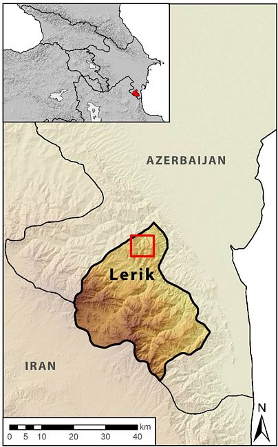
perspectives of local residents dwelling in this area. Fig.1: Map of Lerik region, with zone of fieldwork indicated by red box.
Highlands are complex and challenging spaces. They are diachronic hotbeds of cultural, ecological, and linguistic diversity (Körner 2002; Nichols 2014; Stepp, Castaneda, and Cervone 2005), and are uniquely vulnerable to conflict; half of all armed conflicts in the late twentieth century involved mountainous areas (Libiszewski and Bächler 1997), although such areas acount for only 25% of the world landmass (UNEP WCMC 2002). Yet highlands are often defined as "peripheries," excluded from the political histories of the "centers" they surround, despite their central role in regional systems.
The political complexity of the highland regions of the South Caucasus makes them exceptional places to explore the dynamics of highland-empire engagement. The LAAP investigates these highlands as a center of interaction, and thus critical to understanding regional economic, political, and cultural dynamics (Glatz and Casana 2016; Scott 2009). This project seeks to reconstruct the choices of these local residents, seeing them as part of a dynamic network of interaction that stretched through vast imperial spaces and far into the imperial ‘in-between.’
LAAP works in the Əliabad-Gürdəsər-Buruq valley system, a ca. 40 sq.km territory in Azerbaijan’s southern Lerik district, where recent explorations have demonstrated the presence of both mortuary and settlement contexts from IA III and IA IV. The project asks the questions: What were the highland populations’ engagements with and responses to imperial neighbors during the IA III (Achaemenid-Seleucid) and IA IV (Parthian-Roman) periods?
Previous Work at the Site/Region
The Talış Mountains were the site of some of the earliest archaeological work in the eastern South Caucasus, with the exploration of Henry and Jacques de Morgan in the late 1890’s. However, limited scientific archaeological research was conducted in the region following this early start.
The work of LAAP grows out of research at the site of Piboz Tәpә, located in the village of Gürdəsər, in the Lerik district of Azerbaijan. The site was first recorded in the 1980s, when it was encountered during road construction. Human remains were later found in the process of home construction, after
 which the site went undisturbed
until scientific excavation began in 2012 led by Dr. Jeyhun Eminli of
the Azerbaijan National Academy of Science. Since then, his work at the
site has uncovered over 180 burials from two broad chronological
periods: 1) the Achaemenid to Parthian Period, from which the majority
of burials date and 2) the Medieval Period, which has a smaller
presence (Eminli and Iskenderov 2016).
which the site went undisturbed
until scientific excavation began in 2012 led by Dr. Jeyhun Eminli of
the Azerbaijan National Academy of Science. Since then, his work at the
site has uncovered over 180 burials from two broad chronological
periods: 1) the Achaemenid to Parthian Period, from which the majority
of burials date and 2) the Medieval Period, which has a smaller
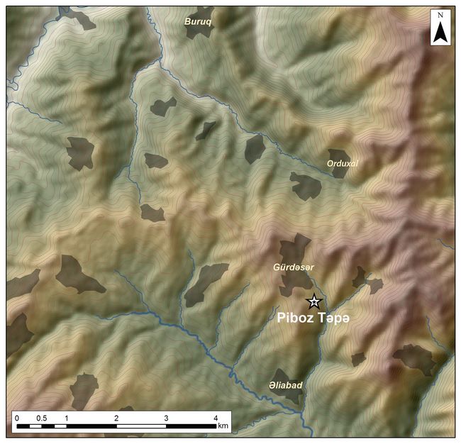
presence (Eminli and Iskenderov 2016).Fig.2: Map of Əliabad-Gürdəsər-Buruq valley system.
In 2016, Dr. Lara Fabian and Dr. Susannah Fishman joined Eminli to develop complementary and collaborative regional research under the umbrella of LAAP, exploring the wider landscape around Piboz Təpə and investigating its’ regional context.
Work in 2016 included 1) test excavation at a suspected settlement site (Yoladoy Bin) located below the cemetery and 2) survey of 18 km2 of the surrounding area. During this season, LAAP excavators exposed a pisé
 structure with mid-4th to mid-3rd century BCE
radiocarbon dates that compare with samples analyzed from Piboz Tәpә,
demonstrating contemporary low-density settlement adjacent to the
cemetery. The survey employed extensive and intensive methods to
approach the challenging, mountainous terrain of the study area. This
work included 24 200 m2 survey squares and 34 fields at 15 m transects,
encompassing the full range of terrain types from the survey zone. LAAP
mapped known archaeological sites and previously unrecorded contexts,
including cemeteries, settlements, and ceramic scatters dating
primarily between the Late Iron Age and the Medieval period (Fishman et
al. 2017).
structure with mid-4th to mid-3rd century BCE
radiocarbon dates that compare with samples analyzed from Piboz Tәpә,
demonstrating contemporary low-density settlement adjacent to the
cemetery. The survey employed extensive and intensive methods to
approach the challenging, mountainous terrain of the study area. This
work included 24 200 m2 survey squares and 34 fields at 15 m transects,
encompassing the full range of terrain types from the survey zone. LAAP
mapped known archaeological sites and previously unrecorded contexts,
including cemeteries, settlements, and ceramic scatters dating
primarily between the Late Iron Age and the Medieval period (Fishman et
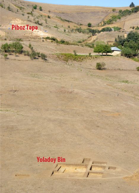
al. 2017).Fig.3: Relationship between Yoladoy Bin and Piboz Təpə.
2017 Funded Research Project (RFF-2017-39)
Goals:
LAAP seeks to build out from work conducted at the Piboz necropolis to understand the wider regional system. Work at the necropolis also continues under the direction of Eminli with the support of the Azerbaijan National Academy of Science. The main objectives of LAAP’s research are to gather archaeological data about domestic life, technological traditions, settlement patterns, and subsistence strategies in the highlands, which complement the mortuary evidence. Analysis of the data will track diachronic practices of continuity and change within social practices, demonstrating the variety of local behaviors as residents engaged with shifting imperial systems. The specific projects of the 2017 season are as follows:
1) Horizontal exposure of the structure discovered at the site of Yoladoy Bin. We succeeded in this as well as exposing surrounding features and an associated burial, excavating an area of 174 m2.
2) Test trench excavations at other settlement sites near Yoladoy Bin. This component of the project was deferred to the 2018 season, due to fieldwork delays and the decision to focus on expanding excavations at Yoladoy Bin in order to better understand the site.
3) A survey of the adjacent valley was limited due to work delays. However, we completed a randomly-sampled intensive survey of the entire Orduxal-Gürdəsər-Əliabad valley axis (approximately 18 km2) and have begun a broader intensive and extensive survey in an additional 20 km2 in the Buruq-Orduxal valley and upland regions.
4) Analyses of excavated materials (e.g. zooarchaeological, paleoethnobotanical, ceramic, bioarchaeological materials) are ongoing, but preliminary results are promising. C14 dates from the 2017 season demonstrate that the structure at Yoladoy Bin, surrounding features, and the cemetery at Piboz Tәpә are roughly contemporaneous, making it possible to compare materials used in different contexts.
Methodology and Findings:
In order to effectively target the low-density highland space of the Əliabad-Gürdəsər-Buruq valley system, LAAP incorporates a diachronic regional surface survey, horizontal exposure at two sites (Yoladoy Bin settlement and Piboz Tәpә necropolis), and laboratory analyses.
Yoladoy Bin Excavation
An area of 174 m2 was excavated in the Yoladoy Bin settlement to reveal the full extent of a domestic structure that was uncovered in a test trench in 2016, dated by two AMS C14 samples to 465-325 BCE (Samples 24.2, 30.2, Table 1) (Figs. 3-4).
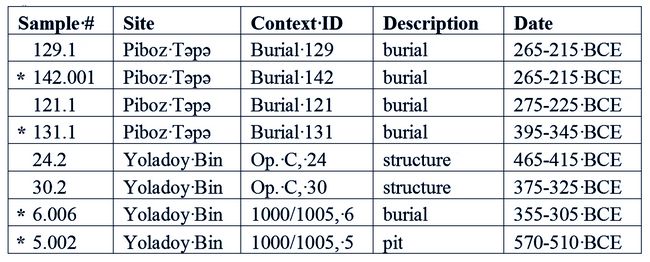
Table 1: C14 Dates
[* indicates C14 dating supported by grant RFF-2017-39.]
.
.
.
Fig.4: Yoladoy Bin excavation area (facing west).
Domestic Structure
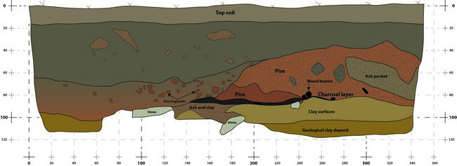
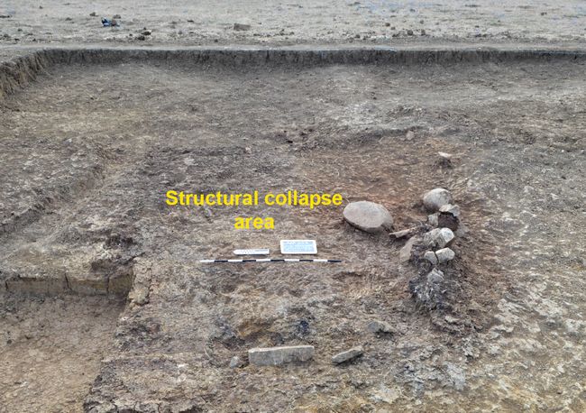
Excavation revealed the full extent of a rectilinear burnt pisé and wood beam structure with a rammed clay floor, including a line of stones that likely served as part of the foundation (figs. 5-6). While the extent of the pisé collapse covers an area of 7.96 x 8 m, the clay floor was only irregularly recovered. A circular concentration of flat stones that likely served as a post-hole was uncovered near the northern edge of the floor, and a 0.56 x 5.46 m trench was cut along the northeastern edge of the structure, probably as part of a drainage system. Ancient inhabitants prepared this area for construction by cutting a terrace into the hillside (fig. 7), with a clear transition from mottled brown construction material and later wash layers, which lay atop the natural yellow clay of the earlier hillside.
There were few artifacts associated with this structure. Finds include two heavy clay loom weights, a 30 cm grinding stone, and simple pottery. Within the structure, 224 sherds were found, of which only 20 sherds were diagnostic. Many of the sherds recovered during excavations refit with each other even along ancient break lines. They are all similar medium-fine pink ware bowls and jars with simple rims and bases. The limited artifact assemblage suggests that this structure was abandoned intentionally, with inhabitants removing the most useful and valuable items for future use elsewhere. Additionally, this suggests that burning the structure may have been an intentional part of the process of the abandonment.
.
.
.
.
Fig. 5: Section through part of pisé collapse, excavated in 2016
.
.
Fig.6: Greater extent of pisé collapse, excavated in 2017.
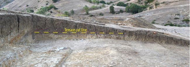
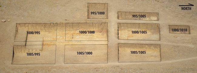
Fig.7: Terrace cut in north baulk of trenches 1000/1000 and 1000/1005.
Burial and Pit Feature
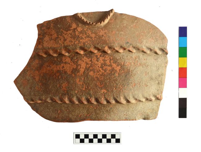
Immediately to the north of the structure, either abutting or cutting into the edge of the collapsed pisé, was a burial of a 25-40 year old male (fig. 8). This individual had an unhealed perimortem indent on the inside of his clavicle, suggesting that he died a violent death from being stabbed in the throat. This individual was interred in an unlined pit in a flexed position. The head was covered with a large ceramic redware sherd (fig. 9). Burial objects include:
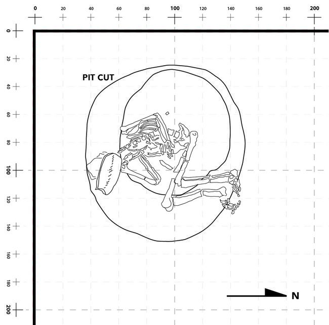 silver earrings, a silver bead, a bronze
lance head, several different types of simple ceramic vessels,
including one cooking vessels in the left hand, and at least two
grinding stone fragments. A radiocarbon sample from charcoal resting on
the pelvis was dated to 355-305 BCE (Table 1).
silver earrings, a silver bead, a bronze
lance head, several different types of simple ceramic vessels,
including one cooking vessels in the left hand, and at least two
grinding stone fragments. A radiocarbon sample from charcoal resting on
the pelvis was dated to 355-305 BCE (Table 1). Fig.8: Yoladoy Bin burial, detail of SW corner of trench 1000/1005.
A 2.45 m diameter, 1.12 m deep pit was found 2 m north of the burial. This pit was characterized by a high density of charcoal and included a few artifacts — a grinding stone fragment and carinated grey burnish
 ed
bowl with Iron Age parallels. A radiocarbon sample analyzed from the
pit dates to 570-510 BCE, making it pre-date the structure and burial
by nearly two centuries (Table 1).
ed
bowl with Iron Age parallels. A radiocarbon sample analyzed from the
pit dates to 570-510 BCE, making it pre-date the structure and burial
by nearly two centuries (Table 1). Fig.9: Sherd placed above skull of Yoladoy Bin burial.
Piboz Tәpә
In addition to the excavation of the Yoladoy Bin settlement, work continued at Dr. Eminli's excavation of the Piboz Təpə cemetery (fig. 3). In 2016 and 2017, 55 burials were excavated with individual human remains from approximately 500 BCE to 900 CE. Radiocarbon dates were analyzed from four burials, providing a date range of 395-215 BCE (Table 1), with the broader date range inferred from stylistic parallels in burial goods. These burials contain bronze weapons, jewelry, and elaborate pottery, as well as sheep, goats, and horses. Analysis of the human remains shows that this cemetery was primarily for adults. The population has high prevalence of degenerative joint disease from activity stress, dental decay related to a diet high in cereal grains, and dental wear and chipping caused by dietary grit inclusions. There are few instances of trauma mostly due to accidental injury. Animal remains included in burials were also analyzed.
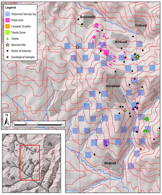
Survey
We completed a randomly-sampled intensive survey of the Orduxal-Gürdəsər-Əliabad valley axis (approximately 18 km2) and have begun a broader intensive and extensive survey in an additional 20 km2 in the Buruq-Orduxal valley and the upland Laman region (Fig. 8). All visible
 anthropogenic remains were recorded using tablet computers and
mobile phones running a purpose-built database inside of Collector for
ArcGIS, ESRI’s mobile app. The devices were connected to BadElf
Surveyor units, which enhance GPS accuracy to the range of 1-1.5m
(horizontal). Database records include geospatial data as well as
sketches, photographs and classificatory information. This approach
allowed us to substantially build on our findings from 2016 despite
having a shorter amount of time to conduct survey than initially
anticipated.
anthropogenic remains were recorded using tablet computers and
mobile phones running a purpose-built database inside of Collector for
ArcGIS, ESRI’s mobile app. The devices were connected to BadElf
Surveyor units, which enhance GPS accuracy to the range of 1-1.5m
(horizontal). Database records include geospatial data as well as
sketches, photographs and classificatory information. This approach
allowed us to substantially build on our findings from 2016 despite
having a shorter amount of time to conduct survey than initially
anticipated.Fig.10: Survey area.
Material Analyses
Analysis of excavated materials is ongoing. A short synopsis of the material collected and preliminary conclusions are below:
Petrographic analysis
A total of 43 ceramics samples, including 30 from Piboz Tәpә and 13 from Yoladoy Bin, were collected for petrographic analysis by Dr. S. Fishman. Four clay samples were collected to understand the range of local resources available. Preliminary results indicate that all of the domestic, Yoladoy Bin ceramics were produced with local materials, whereas up to 80% of the Piboz Tәpә samples appear to be non-local.
Zooarchaeological analysis
Results from the zooarchaeological study at Piboz Tәpә and Yoladoy Bin conducted by Dr. H. Lau show the close relationship between people and their animals in life and in death in the highlands in the Late Iron Age. People chose to be buried with the animals that carried them and supported their subsistence economy, including horses, cattle, pigs, sheep, and goats. A preliminary isotopic study is being conducted for three horses and nine goats. Results will shed light on ancient animals’, and through them ancient peoples’, mobility patterns.
Human osteological analysis
Dr. S. Nugent conducted osteological analysis of 55 human skeletal remains from Piboz Tәpә cemetery to determine demographic patterns and the prevalence of pathological conditions and trauma in the population. The cemetery was primarily used for adults. The population has high prevalence of degenerative joint disease from activity stress, dental decay related to a diet high in cereal grains, and dental wear and chipping caused by dietary grit inclusions. There are few instances of trauma, and those present are mostly due to accidental injury.
Botanical analysis
Flotation was employed for 14 soil samples from the Yoladoy Bin excavation, allowing for the collection of macrobotanical remains. This analysis is still ongoing by L. Proctor.
Conclusion
The work at Yoladoy Bin in 2017 explored several phases of human activity located on an earthen terrace cut into the side of the hill. Radiocarbon dates from at least three distinct activity areas indicate that the site was used for at least two centuries, overlapping with a key period of use at the Piboz Tәpә necropolis. There are, however, important contrasts between material found at Piboz Tәpә and at Yoladoy Bin. The burial assemblages of the necropolis contain a high proportion of imported ceramics based on fabric type and a selective petrographic analysis (see Material Analyses above) and also include fine metal weapons and jewelry. These types of material culture are found in the one example of a burial outside the necropolis but nearly absent from the excavated domestic contexts at Yoladoy Bin, and particularly from the ceramic assemblage of the collapsed structure, where simple shapes produced from local fabrics dominate.
Expanded work during the 2017 season also demonstrate important similarities between the sites. Artifactual data indicate that communities in the area engaged in an agropastoral economy heavily reliant on grains. An emphasis on herded animals is evident by their inclusion in burials at the necropolis and hinted at in the recovery of artifacts associated with weaving technologies at Yoladoy Bin. Future integration of these multiple complementary data sets, including forthcoming work on the archaeobotanical samples, are essential for understanding these features.
The burial from the terrace, located just north of the collapse structure is an interesting but anomalous feature. A single radiocarbon sample was dated from a secure context within the burial pit and yielded a date roughly contemporaneous with the period of use of the collapsed structure. The stratigraphic relationship between the burial pit and the collapsed structure is, unfortunately, not entirely clear. However, the presence of some degraded pise above the burial pit suggests that the burial preceded the ultimate collapse of the structure, but whether it preceded or was concurrent with the occupation of the structure could not be determined due to taphonomic processes. The burial is markedly different than those from Piboz necropolis along several parameters: (1) the position of the body; (2) the deliberate deposition of a large sherd with applied rope decoration directly atop the head of the interred individual; (3) bioarchaeological markers also differed from the skeletal remains recovered from the necropolis (per analysis conducted by Dr. Nugent). The inclusion of vessels a metal spear point parallels the type of material included in the burials at the necropolis, but their placement within the burial, and the forms of vessels differ. Unfortunately, the spear point is too poorly preserved to permit more detailed stylistic analysis.
Results from 2017 field season accomplished two important and interrelated goals in the LAAP research agenda. Firstly, the excavation of the settlement at Yoladoy Bin provide an important and unique dataset revealing daily life among Iron Age III to IV period communities in the Talış mountains. Artifactual and ecofactual data recovered from the site speak directly to ancient peoples’ material culture practices and subsistence economy. Previous work on explicitly domestic contexts, as well as more broadly on non-mortuary contexts, has been limited in this region. Future work by the LAAP project will focus on identifying and excavating similar small-scale sites associated with the period.
Secondly, our work at Yoladoy Bin has given us the opportunity to hone our methodological practices so that we may enlarge the existing archaeological dataset on this fascinating and important period in Caucasian archaeology. Archaeological survey and excavation conducted with the support of Grant RFF-2017-39 indicate that such occupations, although ephemeral and dispersed, are a feature of the Talış landscape that remain archaeologically visible and recoverable. The degree of investment indicated by the presence of a semi-permanent built structure on the excavated terrace suggests, furthermore, that future excavation in the regions around Gürdəsər village may yield even more extensive and varied traces of past communities’ daily lives.
References
Eminli, Jeyhun, and Emil Iskenderov. 2016. “Archaeological Investigations at Piboz Tapa Necropolis. Lerik, Southern Azerbaijan (Preliminary Report 2012–2013).” In Proceedings of the 9th International Congress on the Archaeology of the Ancient Near East, edited by Oskar Kaelin and Mathys Hans-Peter, 3:699–708. Weisbaden: Harrossowitz Verlag.
Fishman, Susannah G, Jeyhun Eminli, Lara Fabian, and Emil Iskenderov. 2017. “In the Mountains, Between Empires: Notes from the Lerik in Antiquity Archaeological Project.” Expedition Magazine (Spring): 47–49.
Glatz, Claudia, and Jesse Casana. 2016. “Of Highland-Lowland Borderlands: Local Societies and Foreign Power in the Zagros-Mesopotamian Interface.” Journal of Anthropological Archaeology 44, Part A: 127–147. doi:10.1016/j.jaa.2016.09.001.
Körner, C. 2002. “Mountain Biodiversity, Its Causes and Function: An Overview.” In Mountain Biodiversity: A Global Assessment, edited by C. Körner and E. M. Spehn, 3–20. New York: Parthenon.
Libiszewski, Stephan, and Günther Bächler. 1997. “Conflicts in Mountain Areas: A Predicament for Sustainable Development.” In Mountains of the World: A Global Priority, edited by Bruno Messerli and Jack D. Ives, 103–130. New York: Parthenon.
Nichols, Johanna. 2014. “The Vertical Archipelago: Adding the Third Dimension to Linguistic Geography.” In Space in Language and Linguistics, edited by Peter Auer, Martin Hilpert, Anja Stukenbrock, and Benedikt Szmrecsanyi, 38–60. Berlin: Walter de Gruyter.
Scott, James C. 2009. The Art of Not Being Governed: An Anarchist History of Upland Southeast Asia. New Haven, CT: Yale University Press.
Smith, Adam T., Rouben S. Badalian, and Parkev Avetisian. 2009. The Foundations of Research and Regional Survey in the Tsaghkahovit Plain, Armenia. Vol. 1. The Archaeology and Geography of Ancient Transcaucasian Societies. Chicago: The Oriental Institute.
Stepp, John Richard, Hector Castaneda, and Sarah Cervone. 2005. “Mountains and Biocultural Diversity.” Mountain Research and Development 25 (3): 223–227.
UNEP WCMC. 2002. Mountain Watch: Environmental Change and Sustainable Development in Mountains. Cambridge: UNEP World Conservation Monitoring Centre.
Recent Foundation grants: general Archaeology Grants Program w/map
Copyright © 2019 Rust Family Foundation