Rust Family Foundation: Archaeology Grants Program
Investigating the Quality of Life in Ancient Maya Society:
UAS Survey and Settlement Mapping at Altar de Sacrificios, Guatemala
Principal Investigator: Dr. Jessica Munson
Department of Anthropology-Sociology, Lycoming College
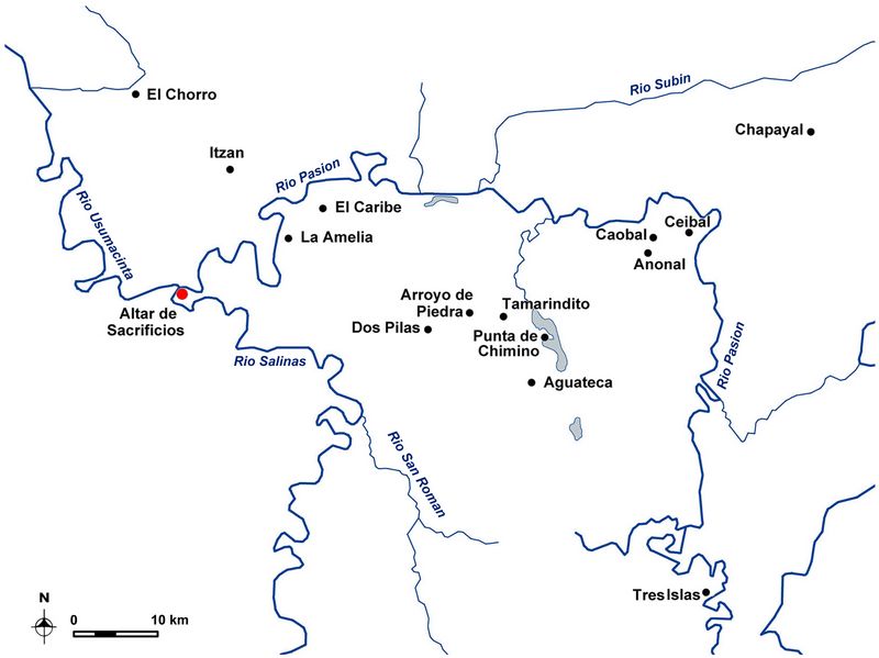
The Proyecto Arqueológico Altar de Sacrificios is a multidisciplinary research project investigating the social and economic changes associated with some of the earliest Maya settlements in the Upper Usumacinta Confluence Zone (UUCZ). Although earlier investigations at Altar de Sacrificios (fig.1)generated a substantial amount of information about the ritual activities and construction sequence of monumental buildings in the ceremonial core, there is currently little known about this prehispanic city’s sustaining population, settlement patterns, and domestic life of households living beyond the core area.
 Research
carried out to date, and supported by the current grant [RFF-2017-38],
has documented the traces of ancient human habitation in a 50 km2 study
area along the Pasión, Salinas-Chixoy, and Usumacinta drainages, which
provides important baseline information to begin investigating the
social and economic dimensions of daily life in ancient Maya society.
Research
carried out to date, and supported by the current grant [RFF-2017-38],
has documented the traces of ancient human habitation in a 50 km2 study
area along the Pasión, Salinas-Chixoy, and Usumacinta drainages, which
provides important baseline information to begin investigating the
social and economic dimensions of daily life in ancient Maya society.
Fig.1: Map of riverine region of Altar de Sacrificios.
While we eventually plan to conduct large scale household excavations, this first stage of research identifies and documents the distribution of domestic contexts we will eventually sample. Towards this end, the primary goal of the current project was to identify the areal extent of Altar’s primary settlement zone as well as the locations of Preclassic residential structures.
Previous Research:
The Upper Usumacinta Confluence Zone (UUCZ) is defined by the lower limits of the Pasíon and Salinas-Chixoy rivers where they merge to form the Usumacinta river (figs.1,2). The largest and most well-known site in the region is Altar de Sacrificios, situated on high ground along the southern bank of the Pasíon river about 2 km east of where the confluence is today.
Recognized for its potential importance as a prehispanic crossroads, the site witnessed one of the earliest large-scale projects in southern Petén. Following earlier explorations by Maler (1908) and Morley (1938), William Bullard prepared the first and to-date only detailed map of the site core during the 1959 and 1960 field seasons following earlier sketches by Shook (published in Morley 1938). This occurred as part of Gordon Willey and Ledyard Smith’s (1969) archaeological investigations at the site from 1958-1963, which established a site chronology based on an intensive excavation program and ceramic analysis (Adams 1971; Smith 1972).
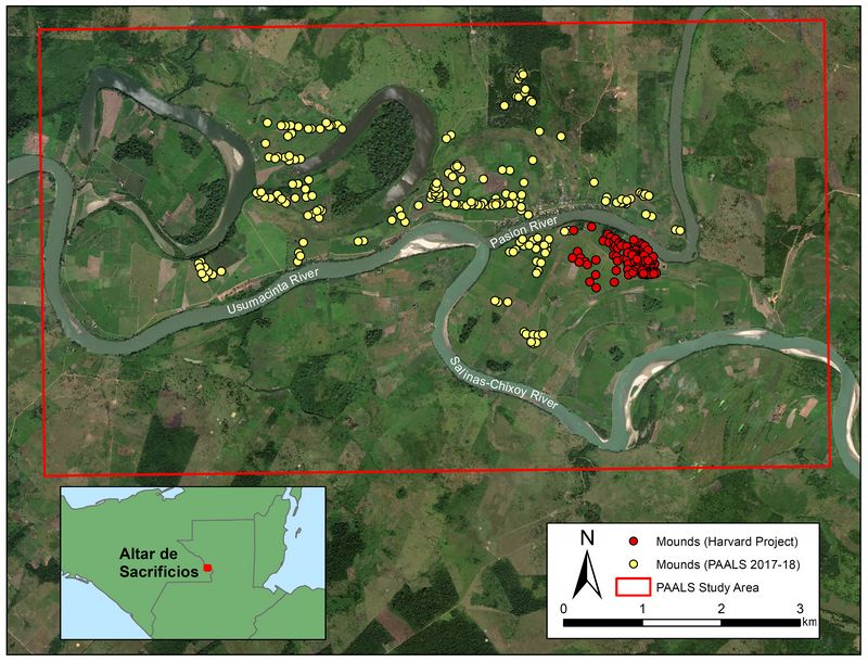
Fig.2: Study area for the Proyecto Arquelógico Altar de Sacrificos showing the location of mounds identified in the 2017-18 field seasons and those previously documented by the Harvard Project.
Funded Research Project (RFF-2017-38)
Goals:
The originally proposed project focused on the identification and documentation of ancient human settlement in a 4 km2 study area around the Maya site of Altar de Sacrificios. Given the success and efficiency of our field collection methods, we were able to expand the study area and documented 7.5 km2 in 2017 with an additional 14.5 km2 along the northern bank of the Pasíon/Usumacinta in 2018. Although the data are still being processed, we covered an additional 20 km2 along the southern bank of the Salinas-Chixoy/Usumacinta in Mexico during the 2019 field season. Here we report the field methods and findings from our 2017-18 research in Guatemala.
Methodology:
PAALS has received permission from the Departamento de Monumentos Prehispánicos y Coloniales (DEMOPRE) in Guatemala along with permissions from local landowners to conduct unmanned aerial system (UAS) surveys over a 22 km2 study area surrounding Altar de Sacrificios and along the northern bank of the Pasión/Usumacinta rivers. To conduct the aerial surveys, we used a DJI Phantom 3 Professional UAS with a 12.4 megapixel proprietary camera, and a GPS/GLONASS positioning system. The UAS was controlled with an Apple iPad mini 2 running the Map Pilot v. 2.6 app produced by Maps Made Easy/Drones Made Easy.
To maximize the amount of area surveyed, we first walked roughly to the center of the study grid of interest, and planned a survey mission using the app. The application programs the UAS such that it flies in a grid above the survey area while taking pictures at a pre-defined interval and elevation. In this case, within the peninsular area of Altar de Sacrificios, we flew at an elevation of 85 m to maximize resolution. In other areas, we flew at an elevation of 150 m above the take-off point to maximize the potential area surveyed. Once the mission is planned, the UAS is launched and flies for approximately 18 minutes due to battery limitations. Once the UAS returns to the launch site, we change the battery and it returns to resume the survey grid until all the batteries are exhausted.
Back at the field camp, the pictures were processed using Agisoft Metashape—a Structurefrom-Motion photogrammetry software—to produce 3D models and DEMs from the raw images obtained by the drone. We opted to process the images using a somewhat-reduced quality reconstruction in order to rapidly obtain DEMs that we could ground-truth in the field the next day. Regardless, such reconstructions achieved resolutions around 40 cm/pixel. Using these images, we identified potential features of archaeological interest which we were able to groundtruth with pedestrian survey and total station mapping the following day, yielding a highly efficient and cost-effective survey methodology. Additional images were later processed in the lab using an increased-quality reconstruction with all images stitched together, resulting in topographic models with a resolution of 15 cm.
Results:
High-resolution images produced from these analyses permit identification of a number of features that would not otherwise be possible. In this section we present the results from the UAS settlement survey conducted during the 2017 and 2018 field seasons. Although grant RFF-2017-38 only supported the 2017 fieldwork, our initial results required an additional year of research to confirm some of the larger-scale patterns observed from the data obtained during the first field season.
Settlement patterns:
The primary goal of the UAS survey was to efficiently detect and document the extent of past human habitation surrounding the ancient Maya site of Altar de Sacrificios. Results of these aerial surveys reveal a dispersed pattern of settlement on the western half of the peninsula and along the paleochannels and oxbow lakes to the west of the modern village of Pipiles. In total, we have identified 196 new mounds in this sector. Those on the main peninsula have been verified and mapped using the total station (25.5% n=50) and we plan to seek additional permissions to validate our new findings in future field seasons
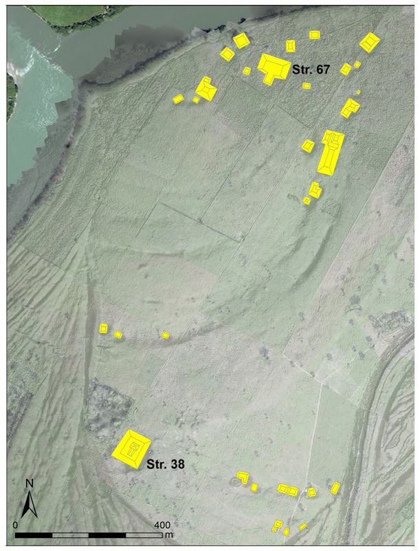
Fig.3: Closeup view of Grupo Frontera.
Most surprising, and exciting for us, was the identification of a new ceremonial group on the western edge of the Altar peninsula (fig.3) This group of mounds that we call Grupo Frontera consists of a north-south alignment of large earthen mounds located along a relic river channel. A dense cluster of smaller and medium-sized earthen mounds surrounds the second tallest mound at the site (Str. 67), located at the north end of this group. This mound stands 10.6 m tall and Str. 38, the southern mound, measures just over 7 m tall. The distance between the midpoints of these mounds is just over 1 km (1.09 km) and they are aligned 20 degrees off north. From the tops of both mounds, one is afforded 360-degree views of the surrounding landscape including clear vistas of the river juncture. The broad flat expanse of land that lies between these mounds may represent a large plaza although no formal definition of this space is visible from the modern ground surface.
Of the mounds in the northern part of Grupo Frontera, Str. 50 is the largest platform measuring 117 m long and 6.3 m tall. The layout and orientation of this mound in relation to the western mound Str. 69 is reminiscent of a possible E-group configuration, although confirmation of this interpretation rests on future investigations. Nonetheless, taken together these features (e.g., north-south axial arrangement of large earthen mounds, large open plaza, and a northeastern platform) appear to represent the minimal characteristics of the Middle Formative Chiapas pattern originally defined by Clark and Hansen (2001) and more recently discovered at nearby Ceibal (Inomata 2017). Inomata and his team have firmly dated the presence of this formalized spatial plan in the Pasíon region to as early as 950 BCE. Although we have not yet carried out any excavations in Grupo Frontera, a test pit excavated in Str. 38 by Harvard uncovered the highest concentration of Middle Preclassic (San Felix and Xe) ceramics found during their investigations lending some support for the occupation of at least one of these mounds during the time period of interest. Additional evidence for Preclassic activity at Altar comes from Harvard’s investigations in the ceremonial Group B and limited test pitting of the house mounds (Smith 1972). While these data reveal significant occupation in the Middle Preclassic, additional research is needed to determine the extent and organization of Altar’s Preclassic population.
Landscape of rivers:
Viewed from above, one of the most striking features of this landscape is the dynamic fluvial environment in which Altar is located. One can clearly make out relic river channels, areas of deposition and erosion, arroyos, and current oxbows in the high-resolution DEM (fig.4).
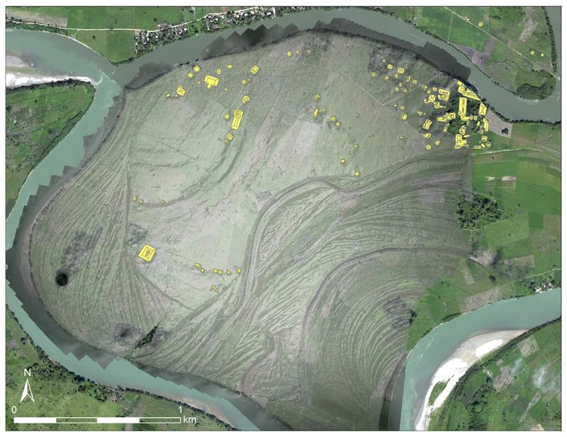 Fig.4:
Topographic model generated from the UAS survey conducted during 2017.
Notice the scroll bars along the southern and western edge of the
peninsula.
Fig.4:
Topographic model generated from the UAS survey conducted during 2017.
Notice the scroll bars along the southern and western edge of the
peninsula.Although it is difficult to date the changing meander of these rivers without additional geomorphological research, we can better understand the settlement layout if we take into consideration these hydrological features. A paleochannel oriented north to southwest cuts through the main peninsula leaving a low and flat depression on the landscape. What was once probably an ancient river course eventually filled with alluvial deposits creating fertile soils that are now used for growing maize, beans, squash, and peppers. Local informants tell us that this land periodically floods during the rainy season and is more productive than adjacent fields on the other side of the Pasión river. Given that there are no visible mounds located in this paleochannel, we suspect that this relic waterway may predate the ancient settlement and could have been an important resource for farming as it is today. Modifications to the relic river banks may have been used for flood control but testing and dating of these anthropogenic features will require future archaeological excavations.
Fluvial processes such as alluvial deposition and erosion created additional features which are clearly visible in these images. For example, the swirls and curves in the southern half of fig.3 show the previous meanders of the Salinas-Chixoy River. This swiftly moving river has eroded nearly 30 m of shoreline along its northern bank in a just a single year based on calculations from our UAS surveys. Similar erosion along the southern bank of the Pasíon cut away at least half of Str. A-I sometime prior to Maler’s rediscovery of the site in 1895. On the north bank of the Usumacinta, just west of the modern village of Pipiles, an oxbow and river cutoff can also be
observed (see fig.2) These waterways were likely formed by flooding and erosion that cutoff relic meanders to create the more direct river channel of the Usumacinta seen today. Without additional geomorphological research, it is difficult to determine when these hydrological features were formed.
Practical implications:
The results of our UAS survey allow us to detect archaeological and geomorphological features across a broad region. However, it is important to remember that these are not static landscapes. The settlement patterns we observe today are in part the result of the changing fluvial environment over the last 3000 years. It is impossible to know from these images whether episodes of erosion and deposition destroyed mounds that may have once been located along the southern peninsula. Moreover, it is difficult to estimate the size and shape of the ancient landforms and river courses along which these mounds were constructed. What these high resolution and multi-temporal images can tell us, however, is how quickly they are eroding today.
The timing of our fieldwork in 2017 coincided with field preparation for planting, which allowed us to fly the drone both before and after these fields were plowed. Since we had models of the mound elevations before and after plowing, we were able to calculate the total amount of soil removed as well as changes in the overall size, shape, and form of the earthen mounds by subtracting the post-plow model from the pre-plow model. With just a single pass of the plow, between 6-9 cm of soil was removed from some of lowest mounds resulting in a loss of more than 6% of the total mound volume. We recalculated soil erosion after the 2018 field season and learned that between 30-50 cm of soil were lost in a single year. The results are unequivocal: these mounds are under significant threat and may be completely obliterated within a few short years. It is therefore imperative to work collaboratively with local landowners, community members, and government officials to further investigate these mounds before they are lost forever.
Conclusions and Future Research:
Preliminary data collected from this regional survey provide important information about the location and density of ancient human settlement within the UUCZ. This information contributes to ongoing PAALS research by providing the baseline data needed to identify domestic contexts of interest for future excavations. As a result of this project’s findings, we are also initiating a new phase of interdisciplinary research focused on reconstructing landscape changes in this dynamic fluvial environment in collaboration with a geomorphologist and environmental scientists. Our preliminary findings also raise important methodological and ethical issues about the application of UAS technology for archaeology. A paper is currently in preparation that
addresses these important issues
A list of presentations and publications based on this research is provided below:
Presentations:
2016 Munson, Jessica. “Proyecto Arqueológico Altar de Sacrificios: Nuevas investigaciones y resultados de la primera temporada, 2016.” Paper presented at the XXX Simposio de Investigaciones Arqueológicas en Guatemala, Guatemala City. July 22.
2018 Munson, Jessica. “Mapeo de asentamientos de alta resolución con sistemas aéreos no tripulados (SANT) en Altar de Sacrificios, Guatemala.” Paper presented at the XXXII Simposio de Investigaciones Arqueológicas en Guatemala, Guatemala City. July 24.
2019 Mejía-Ramon, Andrés, Jessica Munson, and Lorena Paiz. “Métodos Multiescalares de Prospección Arqueológica Aerea: Los Recorridos) por dron de Altar de Sacrificios, Petén y Teotihuacan, Estado de México.” Roundtable presentation at the XXXIII Simposio de Investigaciones Arqueológicas en Guatemala, Guatemala City. July 17.
Publications:
2017 Munson, Jessica and Lorena Paiz Aragón (eds). Informe del Proyecto Arquelogógico Altar de Sacrificios, La Temporada 2016. Informe entregado al Instituto de Antropología e Historia de Guatemala.
2018 Munson, Jessica and Lorena Paiz Aragón (eds). Informe del Proyecto Arquelogógico Altar de Sacrificios, La Temporada 2017. Informe entregado al Instituto de Antropología e Historia de Guatemala.
2019 Munson, Jessica, Andrés Mejía-Rámon, and Lorena Paiz Aragón. Mapeo de asentamientos en alta resolución con sistemas aéreos no tripulados en Altar de Sacrificios, Guatemala. In XXXII Simposio de Investigaciones Arqueológicas en Guatemala, Tomo II. Edited by Barbara Arroyo, Luis Méndez Salinas, and Gloria Ajú Álvarez. Museo Nacional de Arqueología y Ethnología, Guatemala City.
References:
Adams, R. E. W.
1971 Ceramics of Altar de Sacrificios, Guatemala. Vol. 63, No. 1. Papers of the Peabody Museum of Archaeology and Ethnology. Harvard University, Cambridge.
Clark, John E., and Richard D. Hansen
2001 The Architecture of Early Kingship: Comparative Perspectives on the Origins of the Maya Royal Court. In Royal Courts of the Ancient Maya, edited by Takeshi Inomata and Stephen D. Houston, 2: Data and Case Studies: pp. 1–45. Westview Press, Boulder.
Inomata, Takeshi
2017 The Emergence of Standardized Spatial Plans in Southern Mesoamerica: Chronology and Interregional Interactions Viewed from Ceibal, Guatemala. Ancient Mesoamerica 28(01):329–355. DOI:10.1017/s0956536117000049.
Maler, Teobert
1908 Explorations of the Upper Usumatsintla and Adjacent Regions: Altar de Sacrificios; Seibal, Itsimté-Sácluk; Cankuen. Memoirs 4(1), Peabody Museum of American Archaeology and Ethnology, Harvard University. Harvard University, Cambridge.
Morley, Sylvanus G.
1938 The Inscriptions of Peten. Carnegie Institution Publication No. 437. Carnegie Institution of Washington, Washington, DC.
Smith, A. Ledyard
1972 Excavations at Altar de Sacrificios: Architecture, Settlement, Burials, and Caches. Vol. 62, No. 2. Papers of the Peabody Museum of Archaeology and Ethnology. Harvard University, Cambridge.
Willey, Gordon R., and A. Ledyard Smith
1969 The Ruins of Altar de Sacrificios, Department of Peten, Guatemala: An Introduction. Vol. 62, No. 1. Papers of the Peabody Museum of Archaeology and Ethnology. Harvard University, Cambridge.
Recent Foundation grants: general Archaeology Grants Program w/map
Copyright © 2020 Rust Family Foundation