Rust Family Foundation: Archaeology Grants Program
The Welsh origins of Stonehenge
Principal Investigator: Michael Parker Pearson
Professor, University College London, Institute of Archaeology
 One
of the great mysteries of prehistory is why Stonehenge’s ‘bluestones’
came from over 140 miles away in west Wales. While Stonehenge’s sarsen
stones are thought to be local to the Avebury area, 20 miles to the
north, the smaller bluestones (weighing 1-3 tons) came from the Preseli
hills of west Wales. Our aim is to find out why Stonehenge was built of
stones from such distant sources.
One
of the great mysteries of prehistory is why Stonehenge’s ‘bluestones’
came from over 140 miles away in west Wales. While Stonehenge’s sarsen
stones are thought to be local to the Avebury area, 20 miles to the
north, the smaller bluestones (weighing 1-3 tons) came from the Preseli
hills of west Wales. Our aim is to find out why Stonehenge was built of
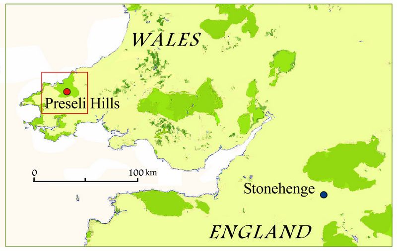
stones from such distant sources.Fig.1: Location of the Preseli Hills in Wales with relation to Stonehenge. Detailed inset of the site area is shown in fig.2.
.
Previous Work
Over the last six years, the Stones of Stonehenge project has identified and excavated two of the outcrops from which bluestones were quarried in c.3300-3000 BC, before these megaliths were erected at Stonehenge in its first stage in c.3000-2900 BC. Archaeologists and geologists have hypothesised that Stonehenge’s bluestones might have first been erected as a stone circle in west Wales, that was later dismantled and moved to Salisbury Plain, rather than being brought directly from their quarries.
2017 Funded Research Project (RFF-2017-23)
Goals:
The current project aims to establish whether there was indeed a stone circle or henge complex in west Wales from which the bluestones were taken.
The project’s overall goals are:
1. To investigate the source area of Stonehenge’s bluestone monoliths in the Preseli hills, identifying megalith quarries and locating other Neolithic sites and monuments associated with bluestones.
2. To discover whether the bluestones were incorporated initially into one or more Pembrokeshire monuments before being transported to Wiltshire.
3. To explore the quarrying of the bluestones in Preseli and their subsequent use, including their journey to Stonehenge, to clarify the purpose of Stonehenge.
In 2017 our specific goals were:
1. To establish whether a group of circular enclosures at Pensarn were remains of a complex of Neolithic henges that might have formed a regional centre of power linked to the quarrying of the bluestones.
2. To establish whether an arc of standing stones
 (Waun Mawn) formed the
remains of a dismantled Neolithic stone circle where the bluestones
were first erected before being moved to Stonehenge
(Waun Mawn) formed the
remains of a dismantled Neolithic stone circle where the bluestones
were first erected before being moved to StonehengeGeological context:
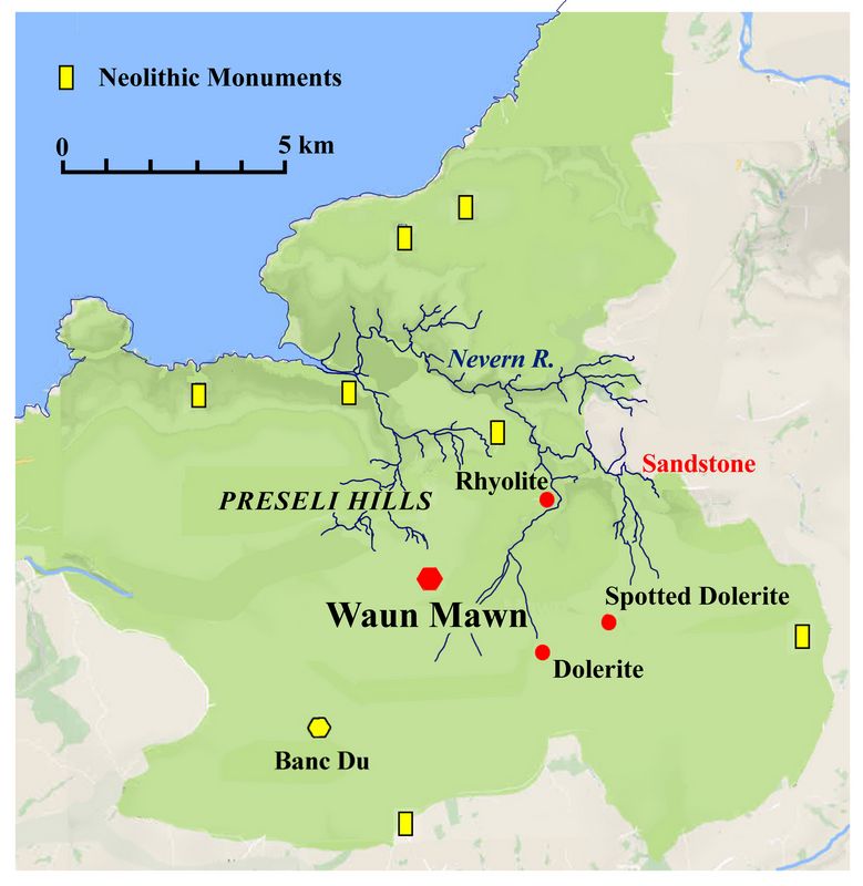
Four of Stonehenge’s different types of bluestones have been identified to their geological sources in Pembrokeshire, west Wales (fig.2). Two of these are spotted dolerite and rhyolite, provenanced to outcrops at Carn Goedog and Craig Rhos-y-felin respectively. Remains of megalith-quarrying at these two outcrops have been dated to the period shortly before 3000 BC.
Fig.2: Waun Mawn in relation to identified bluestone sources. Yellow sites are other Neolithic monuments.
The bluestones are thought to have been erected at Stonehenge shortly after 3000 BC. For nearly a century, archaeologists and geologists have wondered whether the bluestones initially formed a stone circle in Pembrokeshire that was subsequently dismantled and moved to Salisbury Plain and re-erected as Stonehenge.
Methodology:
Two sites were excavated in 2017, one of them a group of henge-like circular enclosures at Pensarn previously identified by geophysical survey in 2016, and the other an arc of four standing stones at Waun Mawn thought to be the remains of a former stone circle. We completed excavations at the suspected henge complex at Pensarn and also excavated test trenches at the suspected stone circle at Waun Mawn. Furthermore, we carried out geophysical surveys in the vicinity of Pensarn to look for new sites that might be related to Neolithic occupation in the area of the bluestone sources.
Findings:
Pensarn
All four enclosures at Pensarn were evaluated in September 2017 with excavation trenches dug to sample their enclosing ditches and, in the case of the two largest enclosures, to sample their interiors to establish whether these were Neolithic henges.
The large circular enclosure (60m-diameter) turned out to be an Early Iron Age fort (c.500 BC), located on the crown of a low hill at 135m OD. Its surrounding ditch was 1.7m deep and its rampart was formed of upright posts and large stones, all the latter having fallen into the ditch. The fort’s interior was occupied by two Iron Age roundhouses, one of which was 10m in diameter. In the centre of the fort, a small pit containing chippings of spotted dolerite could be the remains of a prehistoric standing stone, dismantled in the Iron Age.
The two smaller circular enclosures (20m and 15m diameter) date to the Late Iron Age c.100 BC. Investigation of the interior of the 20m-diameter enclosure revealed the remains of a small roundhouse (5m diameter). This enclosure’s entrance was placed adjacent to a Late Bronze Age pit (c.800 BC) which contained grinding stones and pottery.
The sub-rectangular enclosure at Pensarn was another Iron Age feature, dating to the end of the Late Iron Age (1st century BC/AD). As the Pensarn enclosures were found to date to the Iron Age, 3000 years later than the bluestone quarries, we can be sure that they were not Neolithic henges.
Waun Mawn
In contrast, the four megaliths found at Waun Mawn do indeed appear to be part of a larger stone circle dismantled in antiquity.
In September 2017 we dug six trenches at Waun Mawn, two of them around the outer two recumbent stones and two pairs of trenches on the east and west sides at each end of the arc.
Waun Mawn, as the name suggests (‘peat moorland’), is a wet, peaty upland on which blanket bog has created a continuous surface layer of peat and creating
 severely
gleyed podzol soils in which the old ground surface beneath the peat
has become demineralised. The largest recumbent stone excavated in
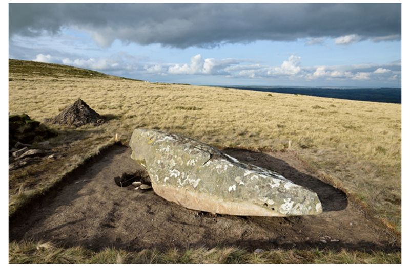
2017 is that on the west side (fig.3). Its former stone socket is
lined with many packing stones, and the peat fills of this socket
indicate that the stone fell after the onset of peat growth.
 Fig 3: The large recumbent stone (Stone 1), viewed from the south; its stone socket is on the left side beneath its end.
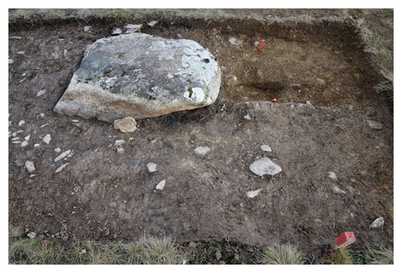
The smaller recumbent stone excavated in 2017 is on the east end of the arc and is just under 1m long (fig.4). The fill of the stone socket contains only brown loam and no peat, indicating that it filled before the growth of peat. Thus this stone came down before peat growth.
Fig.4: The small recumbent stone (Stone 4), viewed from the west; its stone socket is on the right, marked by two red plastic pegs.
Emptied stone sockets with stone packing (but no surviving monolith) were identified beyond both ends of the arc of monoliths. The socket on the west side was a circular pit (0.85 m- diameter and 0.3 m-deep) containing large packing stones set vertically. The emptied socket had filled with brown soil before any peat formation. Deformation of the edge of the pit showed that its former standing stone had been removed towards the north.
We discovered two empty stone sockets on each end of the arc, suggesting that these stones may well be the remains of a dismantled stone circle (figs.5,6). Megaliths were removed from these sockets before the onset of peat growth on this site, indicating that the stone circle was dismantled in the distant past. If this is a former stone circle, as we believe, then its diameter would have been about 380 feet. This would make it the largest known stone circle in Britain except for the outer ring of Avebury, the great henge 20 miles north of Stonehenge.
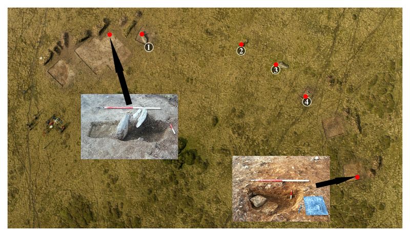
Fig.5: Vertical photograph of Waun Mawn (north is at the top). The sockets for Stones 1-4 and the two newly discovered sockets are marked in red.
The socket on the east side of the arc was a circular pit (0.95m diameter and 0.35m deep) very similar to that in the west, with a similar brown loam fill, except that the two large packing stones were angled against the side and base of the pit’s southern edge, indicating that the monolith in this instance had been removed towards the south.
The dimensions of these emptied stone sockets compare well with those of bluestone holes at Stonehenge, except that the Waun Mawn pits are slightly shallower. This may be accounted for by the more solid geology of Waun Mawn, in contrast to the soft, weathered chalk bedrock at Stonehenge.
No carbonised materials were recovered from the brown loam fills of any of the stone sockets other than a few tiny flecks of charcoal, too small for radiocarbon dating. Until absolute dates are available from excavations in future years (possibly via optically stimulated luminescence [OSL]) , the circle’s erection and dismantling cannot be dated. It can be assumed that the lack of peat in three of the stone sockets indicates that their standing stones were removed before the growth of blanket bog. This is likely to have started growing around 3,000 years ago, which would indicate that the stones came down in the Neolithic or earlier Bronze Age.
The four stones still present are likely to be of dolerite, indicating that their source lies to the east. The dolerite lithology (spotted/unspotted still being investigated), the proximity of four of Stonehenge’s bluestone sources eastwards along the ridge and within the Nevern river catchment below make Waun Mawn a very promising candidate for the former location of Stonehenge’s bluestones prior to their transport to Salisbury Plain to form Stonehenge’s first stage in 3020-2880 BC.
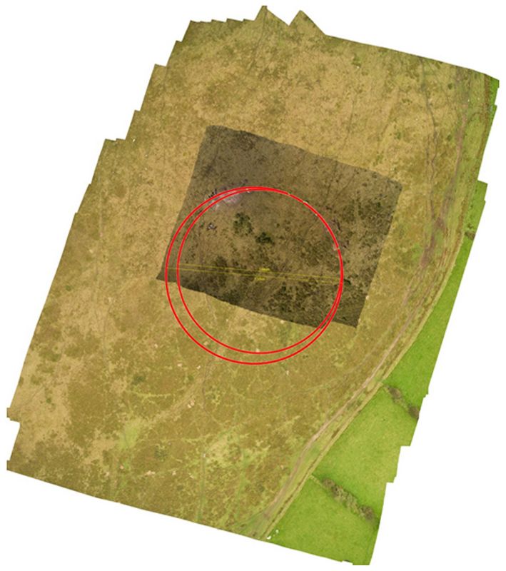
Fig.6: The hypothesised diameter (outer red ring) of the stone circle of Waun Mawn is 115m.
Conclusions:
Investigations into the stones of Stonehenge in 2017 moved from study of the bluestone quarries to exploration of the prehistoric landscape in which Stonehenge’s bluestone sources were located.
The main discovery was that four standing stones in an arc at Waun Mawn, above a source of the River Nevern, are the likely remains of a prehistoric stone circle, most of which was dismantled and removed in prehistory (fig.6). Its 80m-long arc suggests a former diameter of c.115m, which would make it the largest stone circle in Britain except for the outer ring of Avebury. Although excavations in 2017 failed to obtain a date for the stone circle’s erection or dismantling, its stone sockets were emptied and the stones removed before the onset of peat growth. We are currently awaiting radiocarbon dates from the base of the peat, though it is likely to have started forming in the Bronze Age.
Further research is planned for 2018 to confirm that Waun Mawn is a giant stone circle and, if so, when its standing stones were erected and dismantled. Using geological analysis, we aim to establish if the megaliths that once stood here can be matched with bluestones at Stonehenge.
Continuation of geophysical survey around and beyond Pensarn, where the enclosure complex was discovered by magnetometry in 2016, identified two mounds as probable prehistoric features, one to the northeast of the Pensarn complex and the other to its east. That to the east is identical in its magnetic patterning to the one excavated at Pensarn in 2016 which was found to be an Early Bronze Age kerb cairn dating to c.2000 BC.
Publications:
Burl, A. 1976. The Stone Circles of the British Isles. New Haven, Yale University Press.
Grimes, W.F. 1963. "The stone circles and related monuments of Wales." In Foster, I. Ll. and Alcock, L. (eds) Culture and Environment: Essays in Honour of Sir Cyril Fox. London: Routledge and Kegan Paul. 93-152.
Parker Pearson, M., Bevins, R., Ixer, R., Pollard, J., Richards, C., Welham, K., Chan, B., Edinborough, K., Hamilton, D., Macphail, R., Schlee, D., Simmons, E. and Smith, M. 2015. "Craig Rhos-y-felin: a Welsh bluestone megalith quarry for Stonehenge." Antiquity 89: 1331–52.
RCAHMW 1925. An Inventory of the Ancient Monuments in Wales and Monmouthshire. Volume VII. County of Pembroke. London: HMSO.
Recent Foundation grants: general Archaeology Grants Program w/map
Copyright © 2018 Rust Family Foundation