Rust Family Foundation: Archaeology Grants Program
Karphi Revisited: Excavation at a Mountaintop Defensible Town of the Bronze-Iron Age Transition (Crete) in 2021
Principal Investigators: Dr. Saro Wallace
British School at Athens/ HERITAGE
Dr. Ina Berg
University of Manchester
Trial excavations have shown considerable potential for extensive research excavation at the high-altitude site of Karphi, Crete (Late Bronze-Iron Age, c. 1200-1000 BC; figs.1-3). Future work on this large project requires high-resolution recording and mapping of surface architecture, condition observations, conservation planning, excavation setup, and strategy development at the site. This is supplemented by surface recording at an adjacent smaller site (Kera Vigla) and observations, assessment and surface recording at the neighbouring polis site of Kera Papoura, dating c. 1200-600 BC.
The project, with planned later excavation on the Papoura site itself, opens up the political, social and economic func
 tioning of surprisingly large new communities
settling in and transforming this mountainous landscape for the first
time in Crete's history, following the crisis and collapse of Bronze
Age state across much of the east Mediterranean c. 1200 BC. Excavation
at scale but with high resolution, using and building on a range of
scientific analysis techniques, can test models of exceptional
resilience and creative adaptability to crisis in Bronze-Iron Age
Cretan populations (Wallace 2010a) by revealing the mechanisms,
constraints and structures at play in building a large and complex
community and reorienting manufacture, trade and subsistence in a stark
new environment.
tioning of surprisingly large new communities
settling in and transforming this mountainous landscape for the first
time in Crete's history, following the crisis and collapse of Bronze
Age state across much of the east Mediterranean c. 1200 BC. Excavation
at scale but with high resolution, using and building on a range of
scientific analysis techniques, can test models of exceptional
resilience and creative adaptability to crisis in Bronze-Iron Age
Cretan populations (Wallace 2010a) by revealing the mechanisms,
constraints and structures at play in building a large and complex
community and reorienting manufacture, trade and subsistence in a stark
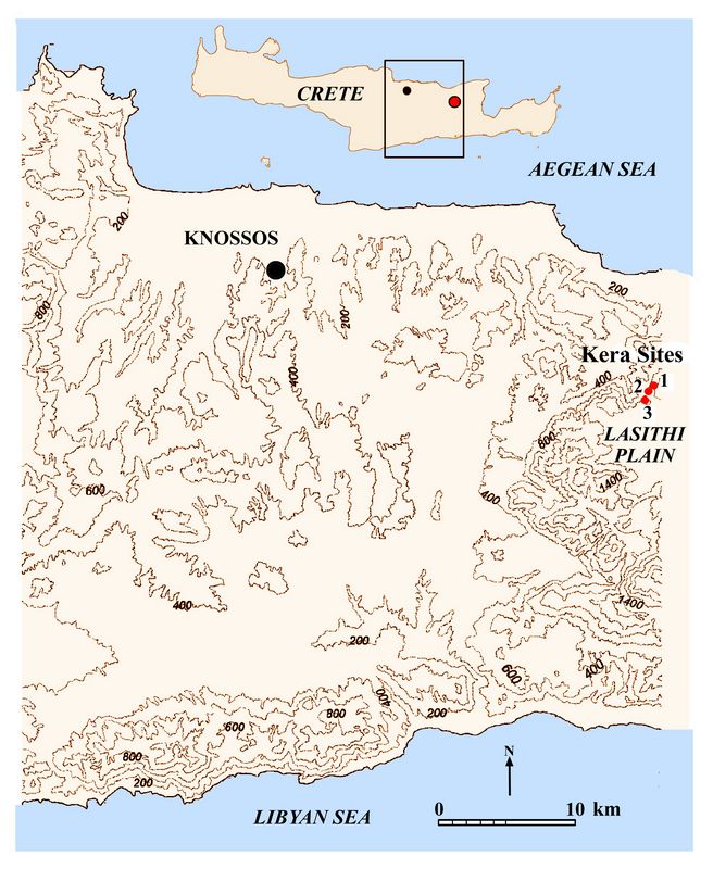
new environment. Fig.1: Location of the three sites dating from 1200 BC forming the focus of work in 2021-22: 1. Karphi; 2. Kera Vigla; 3. Kera Papoura
The mountainous cultural landscape of north Lasithi is currently both under exploited through tourism (in an island where the sustainability of tourism in other settings (e.g. Knossos) is reaching crisis point), and at risk from natural factors including increased winter rainfall, vegetation growth and decline of grazing. The project importantly incorporates studies of attitudes and engagement in local communities and designs participation and training opportunities connected to the excavation and conservation of the site. The aim is to promote the best decisions for the future of this spectacular and historic area.
Previous Research at the site.
The exceptionally large settlement of Karphi was founded high in the Lasithi mountains of Crete (1140m asl) following upheaval across the east Mediterranean c. 1200 BC. The associated rich cultural landscape of cemeteries and settlements of various sizes, ritual memorialised zones and cult places in this dramatic, strategic and defensible landscape has been studied through survey, limited excavation and artefact analysis from the 1930s and then again from the 1980s onwards including, prominently, by senior members of the project team (e.g. Nowicki 1987; 2000; Wallace 2005; 2020).
Karphi was first excavated rapidly over a fifth of its area, along with some associated tombs, by John Pendlebury for the British School at Athens, who followed Arthur Evans in selecting promising and well-preserved prehistoric sites in the area for investigation. Wallace has worked in this cultural landscape since 2002 (undertaking extensive surveys allowing dating and size estimates on settlement zones (2010b; 2020), petrographic study of surface material from six different Iron Age sites (2020), detailed architectural recording of excavated and unconserved remains at Karphi (2005), a range of artefact analyses and scientific studies on the old excavated material (2021), and successful and productive trial excavations indicating (through the first radiocarbon dates) the exact lifespan of the settlement, its revisiting and memorialisation in the later Iron Age and the rich nature of its deposits currently unexcavated (2020). Consultant on the project and planned director on the excavation from 2023, Professor Krzysztof Nowicki has contributed prospective survey and topographical research illuminating the entire north Lasithi area, including the settlement and ritual use of the spectacular and unique fertile Lasithi plain and foothills during the Bronze Age and the nature of its disturbance and relocation c. 1200 BC (Nowicki 1994).
2021 Funded Research Project (RFF-2021-161)
 Goals:
 In 2021-22 the project aims to record surface architectural remains across the site of Karphi in appropriate detail to enable excavation from 2023. In addition, it aims to complete the recording of Iron Age remains visible on the surface of Vigla (fig.3), a small satellite site founded alongside and close to Karphi on a lower mountain spur, and to evaluate and record the extent of architectural remains in detail at Papoura, a site paralleling Karphi in size, likely rehousing Karphi's population after a destruction in 1000 BC, and becoming the regional political and economic centre until c. 600 BC.
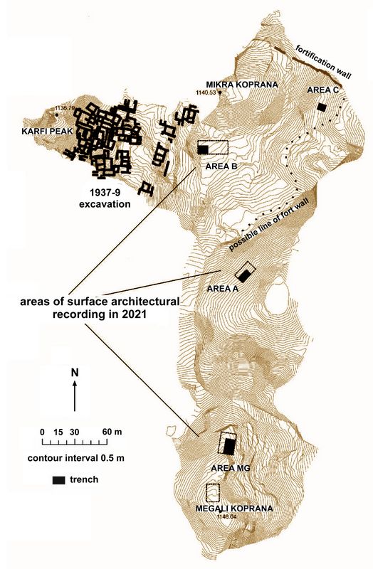
Fig.2: Map of Karphi locations where architectural recording and trench planning work carried out in 2021 (planned excavation areas).
The project aims to complete a full topographical plan of the Papoura site on which these remains can be plotted, similar to the plan already produced for Karphi, It is developing a GIS for the Karphi site to produce a full record of all features and findings in 3 dimensions which can be accessed by researchers and the public.
In parallel with this, work is being completed on quantification and targeted analysis of human remains (DNA and isotopes) metal and ceramic artefacts including textile tools and other non-pottery materials from the 1930s excavations, never fully previously analysed. In 2023-25 the goal, building on this grounding, is to excavate three areas at the Karphi site (fig.2) following their (already published) evaluation by trial excavation and full surface recording; Area B adjacent to the old excavations, where remains of a Middle Bronze Age peak sanctuary underlie the town remains; Area A where there are traces previously trial-excavated by Wallace (2020) of a major public building of a new type, and area MG, an extensive self-contained district.
The research goal is to use the history of new community formation thereby exposed to look at the social and economic adjustments required and managed in response to a region-wide crisis, in a notably extreme habitation environment. An additional goal is to engage the local community and tourism and its benefits with the process and outcome of the research in meaningful ways.
Methodology:
To document site conditions and formation and architectural techniques, quality and density on the three sites of interest, high-resolution photography is used. Alongside residual study and publication of artefact data from the old excavations at Karphi analysed using XRF, LIBS, DNA isotope analysis and aDNA analysis, the new project focuses on recording of surface-preserved architecture topographic information using high-resolution GPS antenna equipment. Architectural plans at 1:50 are manually drawn at the sites of Kera Vigla (fig.3) and Papoura, then plotted on Google Earth underlays (Vigla) and a GPS-made topographical plan (Papoura). At Karphi architectural plans at 1:20 in and beyond designated excavation areas are manually drawn for maximum resolution and mapped onto
 the existing project topographical plan using a Topcon
EDM surveying instrument.
the existing project topographical plan using a Topcon
EDM surveying instrument. In excavation at Karphi, three selection areas demonstrated by previous published trial trenching to have high levels of preservation and research formation are excavated by a trained team of staff and students using established single-context recording methods tested in the trial excavations. These include sampling for organic residues on ceramics, and recovery of archaeobotanical remains through wet sieving at a minimum 30 l sample per context. All visible charcoal and dense archaeobotanical charcoal is hand retrieved in including for C14 dating; all animal bone is retrieved by hand. Dry sieving of all floor and over-floor deposits is carried out. Artefacts go through a cleaning and conservation process at different stages of their quantitative analysis and metallographic analysis is planned at a pre-cleaning stage for selected metal finds.
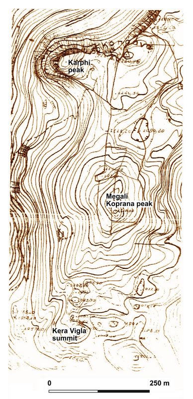
Fig.3: Map of the Kera Vigla location in relation to Karphi (annotated Greek Army Mapping Service 1:5000 map).
A range of postdoctoral and professorial specialists, most of whom worked on the 2008 project, are employed in this work. Specially trained staff and students will work to gather ethnographic accounts and feedback from members of the local community and tourist/general public visiting or otherwise interested in the Karphi site and its neighbours, using established interview and outreach methods including in local schools, with the aim of informing interactive and education work by the project. Members of the local archaeological authority and local workers are employed and trained on the project. All excavated remains are conserved in place using experimental and approved methods for this exposed, frost-affected high-altitude site, with a lime-rich mortar particularly important. Onsite and website interpretation using the research results is designed and installed by the project with the approval of local archaeological authorities.
Preliminary Findings:
 Funded
research in 2021 enabled rapid changes and adaptations in the
project in response to Covid-related and other limitations arising in
the field. A portion of the grant awarded was used as planned to set up
the excavation equipment and training environment required, to
undertake initial ethnographic interviews and observations relating to
heritage attitudes in depth, and to bring the team of 20 students and
staff to the field and train them there.
Funded
research in 2021 enabled rapid changes and adaptations in the
project in response to Covid-related and other limitations arising in
the field. A portion of the grant awarded was used as planned to set up
the excavation equipment and training environment required, to
undertake initial ethnographic interviews and observations relating to
heritage attitudes in depth, and to bring the team of 20 students and
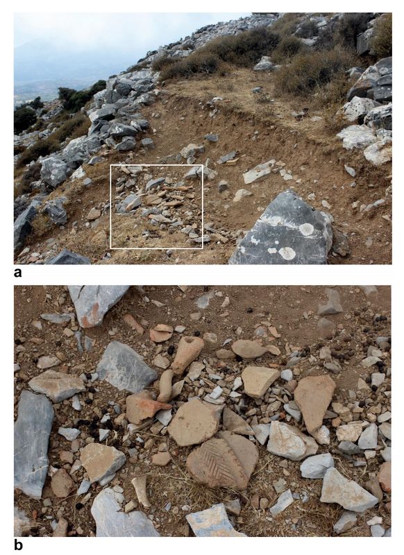
staff to the field and train them there. Fig.4: MG (Megali Koprana) area of the Karphi site discovered to be at high risk from localised climate change (including flash flooding) through condition assessment in 2021, changing future excavation and recording strategy.
As a result of constraints a more extensive range of recording exercises on the Iron Age architecture at Karphi than planned in preparation for excavation in 2023 was undertaken; work at Vigla was completed , while initial condition and extent observations and a photographic record was made at Papoura, enabling work to be planned there for 2022. A comprehensive GIS was set up in QGIS to enable rapid input and retrieval of excavation and surface data results, and students trained in its use. Work relating to Karphi excavations in the 1930s on human and animal bones was able to be completed with aDNA and isotope results expected in 2022.
Bibliography:
Haggis, D.C. 2013. Social organisation and aggregated settlement structure in an Archaic Greek city on Crete. In J. Birch, ed. From prehistoric villages to cities: settlement aggregation and community transformation. New York: Routledge: 63-86.
Nowicki, K. 1987. The history and setting of the town at Karphi. Studi Micenei et Egeo-Anatolici 26: 235-56.
Nowicki, K. 1998. Lasithi (Crete): one hundred years of archaeological research. Aegean Archaeology 3: 27-48
Nowicki, K. 2000. Defensible sites in Crete, LM IIIC-Geometric. Liege: Aegaeum.
Pendlebury, H, J.D.S. Pendlebury and M. Money-Coutts. 1938. Karphi: a city of refuge of the early Iron Age in Crete. Annual of the British School at Athens 38: 57-145.
Wallace, S. 2005. Last chance to see? Karfi (Crete) in the twenty-first century: presentation of new architectural data and their analysis in the current context of research. ABSA 100: 215-74.
Wallace, S., 2010a. Ancient Crete: from successful collapse to democracy's alternatives. New York/Cambridge: Cambridge University Press.
Wallace, S. 2010b. The roots of the Cretan polis. The histories of large settlements in central Crete 1200-700 BC. Archäologischer Anzeiger 2010/1: 13-90.
Wallace, S. 2013. Citadel and city-state. Insights from surface ceramics into sociopolitical change in Protogeometric through Archaic Crete. In W-D. Niemeier, O Pilz and I. Kaiser, eds. Kreta in der Geometrischen und archaischen Zeit. Memmingen: Deutsches Archaologisches Institut/Hirmer Verlag: 103-33.
Wallace, S. 2020, with contributions by R. Banerjea, P. Finch, S. Kyrillidou, M. Morris, D. Mylona, E. Nodarou, M. Ntinou, and M. Scarry. Karphi revisited: a post-crisis settlement in its landscape. London: British School at Athens
Recent Foundation grants: general Archaeology Grants Program w/map
Copyright © 2022 Rust Family Foundation