Rust Family Foundation: Archaeology Grants Program
Excavations at Pyla-Kokkinokremos 2021
Principal Investigator: Jan Driessen
Professor, University of Louvain
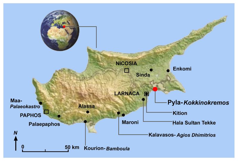
Pyla-Kokkinokremos is the name of a 50 to 63 m high rocky plateau, about 800 m from the present southeast coastline of Cyprus, located in the British sovereign base of Dhekeleia. It is located some 10 km east of Kition and some 20 km southwest of Enkomi (fig.1), two major Bronze Age centres of the 13th-12th c. BC, the period known as Late Cypriot IIC and IIIA.
Because of its limited chronological occupation, its location and its specific material culture, Pyla-Kokkinokremos has attracted a fair deal of scholarly attention and it plays a major role in the discussion on potential Aegean migrations to Cyprus and the Eastern Mediterranean and the archaeology of the Sea People, the coalition that attacked Egypt at the turn of the 13th c. BC. Various factors including the brevity of occupation, its defensible location and many of its finds such as an imported Minoan pictorial amphoroid krater with a magnificent bull caught in a net, an imported Mycenaean amphoroid krater with chariots and people chased by birds with painted signs of Cypro-Minoan script after firing, an imported Sardinian cooking pot with lead repairs, Ugaritic objects, many Canaanite jars and local Cypriot pottery all suggest an ethnic mix that still needs proper explanation.
 An imported deep
bowl from the Argolid which is dated to early LH IIIC is the thus far
latest import on the site from the Greek mainland which has provided a
date around 1190 BC or slightly later for the abandonment of Pyla, at
the close of Late Cypriot IIC or early in LC III.
An imported deep
bowl from the Argolid which is dated to early LH IIIC is the thus far
latest import on the site from the Greek mainland which has provided a
date around 1190 BC or slightly later for the abandonment of Pyla, at
the close of Late Cypriot IIC or early in LC III.Fig.1: Location of Pyla-Kokkinokremos and other sites in Cyprus.
Previous Research at the site.
The site was explored at three previous occasions: first by Dr. P. Dikaios in 1952 (Dikaios 1971) (Sector I & II), then by Dr. V. Karageorghis in 1981-1982 (Karageorghis and Demas 1984) (Sector II) and, more recently, in 2010-2013, by Dr. V. Karageorghis and Dr. A. Kanta (Karageorghis & Kanta 2014) (Sector II and III). Its proximate region also formed the focus of an intensive and systematic surface survey and geomorphological project by an American team under the direction of W. Caraher, S. Moore, J. Noller, and D. Pettegrew since 2003, focusing on the Roman and Late Antique occupation.
Based on these different explorations, it can be assumed that the entire plateau of ca. 7 ha was densely occupied. Most telling is the excavation of part of a regularly laid-out settlement in Sector II of which the outer perimeter wall forms a defensive circuit wall which is assumed to have circled the entire hill top plateau (‘casemate’). The repetition of residential units within the excavated zone seems to suggest that the establishment of the settlement was a deliberate and planned enterprise. Moreover, although some traces of fire were observed, the discovery of material culture including several hidden hoards of precious metals seems to suggest the planned and organised abandonment of the settlement. This and the international character of its finds make it an exceptional site. Moreover, during the recent explorations in the west sector (Sector IV), a possible gate was cleared close to which were found two tablets inscribed in Cypro-Minoan.
The UCLouvain’s involvement at Pyla-Kokkinokremos started in 2014, as part of a joint Belgian-Greek project co-directed by Prof. Joachim Bretschneider of the University of Gent, Dr. Athanasia Kanta of the Mediterranean Archaeological Society in Iraklion and Prof. Jan Driessen of the UCLouvain (see Bretschneider et al. 2015; 2017; 2021). The 2020 campaign, planned for April 2020, eventually had to be postponed to October 2021. The 2021 campaign, between O
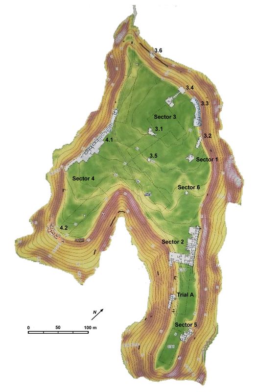 ctober 26 and November 11,
was our 7th fieldwork season. As before we thank the Cyprus Department
of Antiquities and, locally, the Museum of Larnaca for their kind
assistance and collaboration. Our project took place in collaboration
with the Cyprus Institute (Dr. S. Hermon) and we are grateful that our
ceramic team, directed by Dr. Reinhard Jung (OAS-Vienna), was able to
use the Terra Ombra facility of the Larnaca Museum for the processing
of finds. As before, the three teams continued work in the west lobe
(MAS Iraklion, Sector IV), the east lobe (UGent, Sectors V and VII) and
the central plateau (UCLouvain, Sector III) of the heart-shaped hill
(fig.2).
ctober 26 and November 11,
was our 7th fieldwork season. As before we thank the Cyprus Department
of Antiquities and, locally, the Museum of Larnaca for their kind
assistance and collaboration. Our project took place in collaboration
with the Cyprus Institute (Dr. S. Hermon) and we are grateful that our
ceramic team, directed by Dr. Reinhard Jung (OAS-Vienna), was able to
use the Terra Ombra facility of the Larnaca Museum for the processing
of finds. As before, the three teams continued work in the west lobe
(MAS Iraklion, Sector IV), the east lobe (UGent, Sectors V and VII) and
the central plateau (UCLouvain, Sector III) of the heart-shaped hill
(fig.2).Fig.2: General site plan of the Pyla Kokkinokremos Excavations with sectors indicated (N. Kress)
2020-2021 Funded Research Project (RFF-2020-140)
Goals:
The specific task of the UCLouvain is to explore the central plateau (fig. 2), the area which has been most affected by recent agricultural activities (Sector 3). Since earlier and recent excavations have provided us with a good idea of the nature of the occupation along the edges of the plateau and the two southern lobes, our team is especially interested to find out whether a different type of occupation was present in the core area of the settlement. Ideally, we hope to find traces of more complex architectural structures that would help to understand the nature of the societal organisation of the hill-top settlement since neither a palace nor a temple have thus far been identified.
Methodology:
Due to the lack of large surface features, the sampling method has been to install trenches of different sizes in a random way all over the plateau. Only rarely are there surface remains or crop marks to direct this work. Thus far, 11 tests (3.1 to 3.11) have been made, indicated in Fig.2. Some of these tests revealed bedrock immediately while in other cases, agricultural action (ploughing) has considerably damaged the walls.
In 2021, the UCLouvain team continued the work inaugurated in 2019 (Tests 3.10 and 3.11) or even before (Test 3.3).A team, comprising Nicolas Kress, Maud Libert and Christina Mylona, directed by J. Driessen (UCLouvain) consecutively opened spaces 3.3.24, 3.3.26 and 3.3.23 to the very south of the area (fig.3).
Findings:
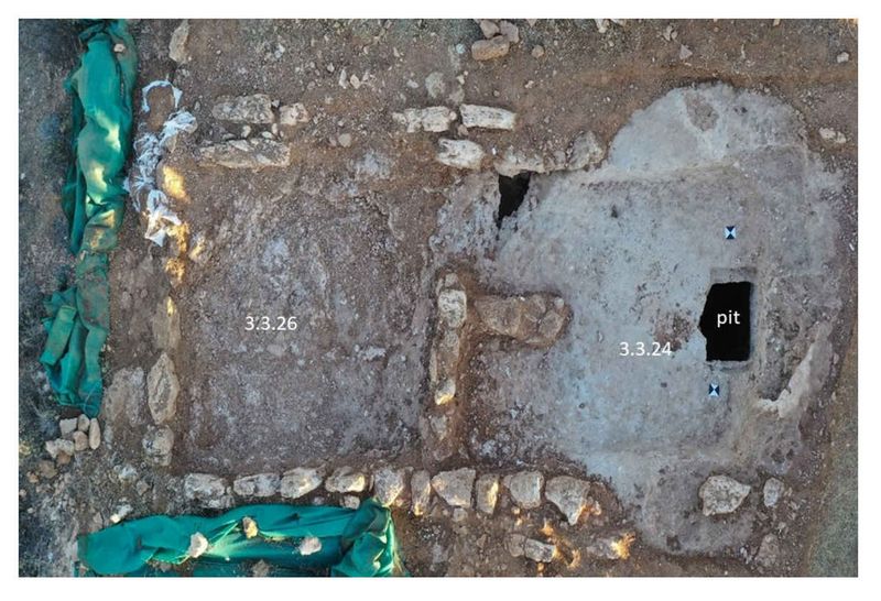
Space 3.3.24 preserves part of the outer casemate wall, which is quite rare in the area since most of it has eroded away because of the slope. Apart from a very smashed pictorial bell krater with a bull, an Argive import, and some bronze scrap on the eroded bedrock floor, the room was empty.
Fig.3: Sector 3.3: Aerial Image of Spaces 3.3.26 & 3.3.24 (north at bottom) (Image: N. Kress).
Through a doorway in a thin partition wall with return, Space 3.3.24 can be accessed directly from Space 3.3.26. Excavation revealed that both its side walls had been constructed on the carefully cut bedrock (and had hence disappeared) and that the room was accessible from the south via a step, cut into the bedrock. A few small vases were found crushed on the bedrock floor as well as a small, fragmentary stone mould, probably for jewellery. The room also had a natural depression close to the door with Space 3.3.24 but this was, apart from a few sherds, empty.
The south part, however, immediately west of the stepped entrance, has a shaft, carefully cut into the bedrock, with a ledge cut at either side of the opening, probably to support a cover in perishable material or a large slab (and part of such a slab was found within the shaft). The opening of the shaft is 0.80 by 0.50 m wide but, as one goes down, becomes larger and having hence a bottle shape. The fill of the 1.80 m deep shaft was very homogenous, comprising moist brown earth with some large stones and, apart from a small bronze vase fragment, it also yielded a spindle bottle, a Canaanite Jar and some other larger vase fragments (pithos, amphora), that are at present under restauration by C. Hadjivasili.
Shafts such as these (although not always as carefully cut) form one of the characteristics of the Pyla site but their function is disputed. Since they cannot hold water, they may have functioned as silos, cooling areas or safe-rooms. Only the surface layers of the adjoining space 3.3.23 were cleared but the outline of the room was clear at the end of the campaign, again showing the typical orthostatic construction.
The same UCLouvain team also continued work in Test 3.11 located at the south side of the central plateau where well-preserved architectural remains had been found and partly revealed in 2019. The area was now enlarged into a 10 by 10 m test and the outline of about ten different spaces was identified (Figure 3). A central space, room 3.11.1, communicates with rooms to the northeast (3.11.2) and northwest (3.11.8) as well as to the south, with space 3.11.7.
The regularity and size of the spaces suggest that the remains form part of a normal domestic building complex similar t
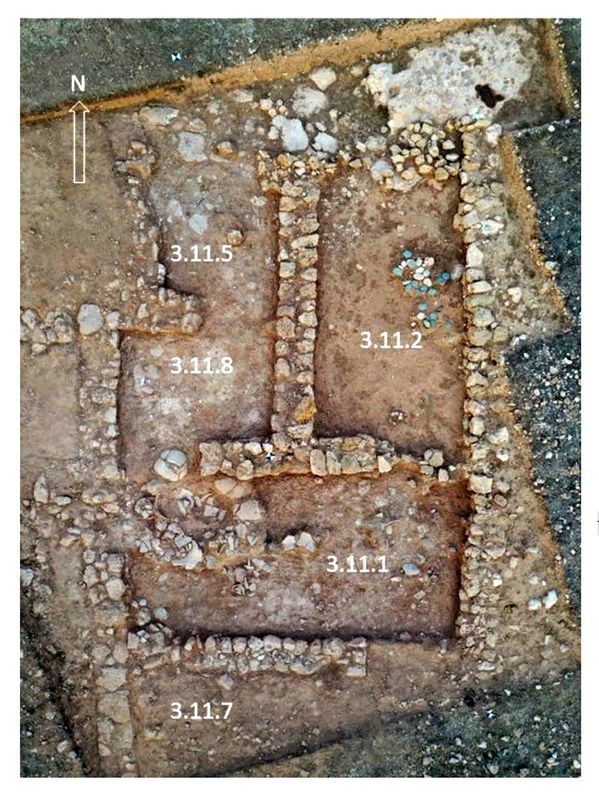 o those cleared by Karageorghis in Sector 2 in
1980-1982. Only the southwest wall of space 3.11.7 is particular in
being built of large, roughly cut slabs, which contrast with the
roughness of the rubble used normally in the wall construction
elsewhere. The entire zone illustrates quite well how the builders
proceeded on arrival: first the walls were constructed on the natural
surface and then the spaces between the walls were excavated to provide
proper floor levels. This means that many walls are in fact sitting on
earth. In areas where the bedrock was close, the latter was cut to
offer an even floor level for habitation. The material left on the
floor consists largely of normal domestic refuse and final abandonment
objects.
o those cleared by Karageorghis in Sector 2 in
1980-1982. Only the southwest wall of space 3.11.7 is particular in
being built of large, roughly cut slabs, which contrast with the
roughness of the rubble used normally in the wall construction
elsewhere. The entire zone illustrates quite well how the builders
proceeded on arrival: first the walls were constructed on the natural
surface and then the spaces between the walls were excavated to provide
proper floor levels. This means that many walls are in fact sitting on
earth. In areas where the bedrock was close, the latter was cut to
offer an even floor level for habitation. The material left on the
floor consists largely of normal domestic refuse and final abandonment
objects.Fig.4: Sector 3.11: Aerial image of the spaces revealed, with Space 3.11.1 in centre (N. Kress)
Apart from room 3.11.2, which had yielded a pithos and a few smaller vases during the 2019 campaign, we concentrated our work on the larger room 3.11.1, which forms something like a passage area connecting different spaces. Its floor deposit yielded a pithos, a Canaanite jar, a plain white jug, a pithoid crater, two trays, a complete wall-bracket and some other fragmentary vases as well as a few stone tools, some scrap bronze fragments including the tip of a blade and a small steatite button, decorated with circles and dots, of the Mycenaean type. On the floor of the room, two small burnt patches were found, perhaps suggesting original roof supports, as well as two stone gournes (perforated stone blocks, weights??). Near the entrance to space 3.11.8 was the beginning of a shallow shaft, cut into the bedrock but it had been given up already at a depth of 15 cm beneath the floor and was empty. Perhaps this work was interrupted just before the abandonment of the settlement took place? Space 8 was found empty while Space 5 yielded a smashed Canaanite jar. Only the surface levels of spaces 3,4,6, 7, 9 and 10 were cleared.
Another UCLouvain team, comprising Nikita Dauby, Alexandrine Rode and Sylvain Rosseel and directed by F. Gaignerot-Driessen (CNRS UMR 5133-Archéorient), resumed work in Sector 3.10, which is situated ca 150 m to the South-West of sector 3.3 and where a Room (3.10.1) was partly excavated in 2019. Then it had yielded, among other things, a stone potter’s wheel of a Near Eastern type.
In 2021, a larger part of the building or complex located in this area was exposed (Fig. 4). It consists of a potentially unroofed courtyard (3.10.3), reachable through an opening in Wall J1. From this area, one can access Room 3.10.1 (ext. dim. ca 2.50 m EW by 6 m NS), which yielded in its northern part several bronze fragments, potentially belonging to the same object.
One of these fragments consists of a plaque depicting the head of a male figure with a beard and wearing a headgear that recalls both the representation of the Peleset on the relief from the Medinet Habu Temple and that of a sphinx on a bronze tripod from Enkomi in the British Museum. It too may have formed part of a bronze tripod stand. A bronze chisel and a lithic tool, potentially used to sharpen metal tools were also recovered from this area, perhaps representing evidence for an industrial context involving metallurgical work.
The important quantity of fragments of plaster recovered shows that the walls of Room 3.10.1 were carefully coated. In the room adjacent to the East, Room 3.10.2 (ext. dim. ca 2.7 m EW by 6 m
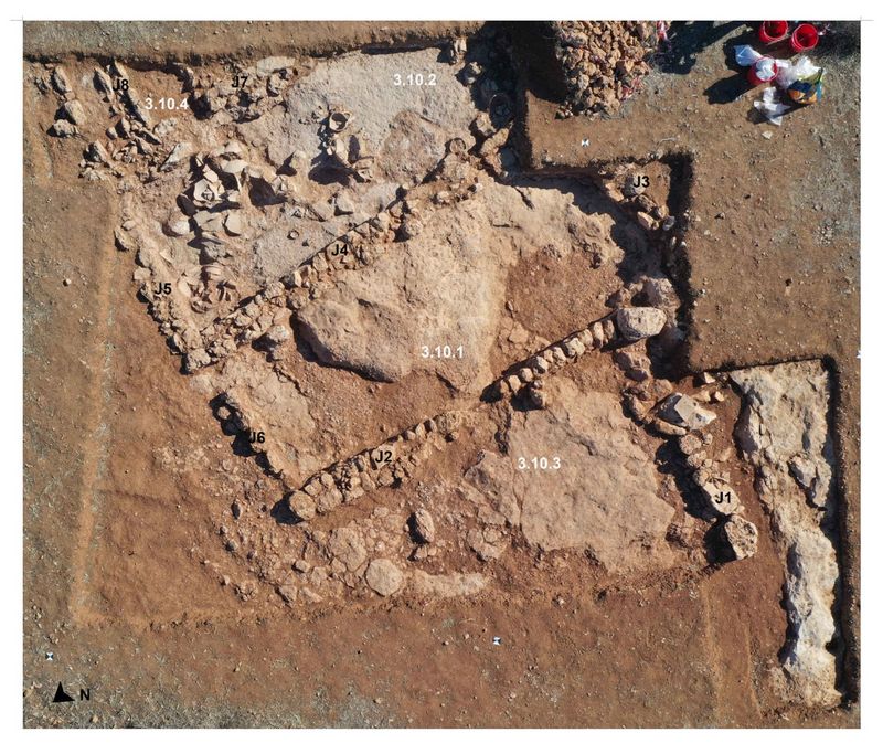 NS), an important
assemblage, notably including six loomweights, lithic tools, a stone
basin, two Canaanite jars, a Palestinian pithos, and several other
large and small vessels, was revealed. Four circular depressions cut
into the bedrock, presumably serving as stamnotheke, notably for the
Canaanite jars, were observed.
NS), an important
assemblage, notably including six loomweights, lithic tools, a stone
basin, two Canaanite jars, a Palestinian pithos, and several other
large and small vessels, was revealed. Four circular depressions cut
into the bedrock, presumably serving as stamnotheke, notably for the
Canaanite jars, were observed.Fig.5: Aerial view of Sector 3.10 (photo: N. Kress, infographics F. Gaignerot- Driessen)
A small part of a third room (3.10.3) adjacent to Room 3.10.2 to the East was also excavated. The base of a large vessel was found on the floor level. Running along Wall J5 and on the northern part of Wall J7, a channel (J8) made of two rows of orthostats and paved with small cobbles was exposed. Its function remains enigmatic. Some general observations can be proposed regarding the architecture brought to light in Sector 3.10: the bedrock is systematically used as foundation for the walls and then cut to serve as floor; as such, it is occasionally levelled with a fill of pebbles and clay; mudbrick is used into the walls and occasionally to fill gaps in the bedrock when it serves as foundation.
Conclusions
While the architectural remains in tests 3.3 and 3.11 find quite good parallels respectively in Sectors 4 and 5 for the spaces connected to the casemate structure and the complex residential architecture that is especially known through the work of V. Karageorghis in Sector 2, both the plan, size and decoration thus far revealed in Test 3.10 are quite exceptional. That this area comprises a well-organized industrial zone in which different crafts were performed in close collaboration is already clear.
The orthostatic wall construction in Sector 3 is quite unusual and may perhaps be added to the various ethnically charged features and objects that have thus far been uncovered on the site. The variety of materials found – Canaanite Jars, Mycenaean kraters etc – agrees with earlier observations and make the site an exceptional case-study to provide a better understanding of the problems connected with the collapse of Bronze Age societies at the end of the 12th c. BC in the Eastern Mediterranean and the role of the Sea Peoples in this discussion.
References:
J. Bretschneider, A. Kanta, J. Driessen, Pyla-Kokkinokremos. Preliminary Report on the 2014 Excavations, Ugarit Forschungen 46 (2015), 1-37.
J. Bretschneider, A. Kanta, J. Driessen, Pyla-Kokkinokremos. Preliminary Report on the 2015-2016 Excavations, Ugarit Forschungen 48 (2017), 35-120.
J. Bretschneider, J. Driessen, A. Kanta, Cyprus and Ugarit at the end of the Late Bronze Age: Insights from Pyla-Kokkinokremos, In V. Matoïan (ed.), Ougarit, un anniversaire. Bilans et recherches en cours, RSO Ras Shamra -Ougarit XXVIII, Leuven, 2021, 607-638.
P. Dikaios, Enkomi. Excavations 1948-1958. II. Chronology, Summary and Conclusions, Catalogue, Appendices, Mainz (1971).
V. Karageorghis, M. Demas, Pyla-Kokkinokremos: A Late 13th century BC Fortified Settlement, Nicosia (1984).
V. Karageorghis, A. Kanta, Pyla-Kokkinokremos: A Late 13th century BC Fortified Settlement. Excavations 2010-2011, Studies in Mediterranean Archaeology 141, Jonsered (2014).
Recent Foundation grants: general Archaeology Grants Program w/map
Copyright © 2022 Rust Family Foundation