Rust Family Foundation: Archaeology Grants Program
Gabii after the Romans:
History of a settlement in Late Antiquity and the Middle Ages.
Principal Investigators:
Nicola Terrenato, Paolo Maranzana, and Marco Cavalazzi
University of Michigan
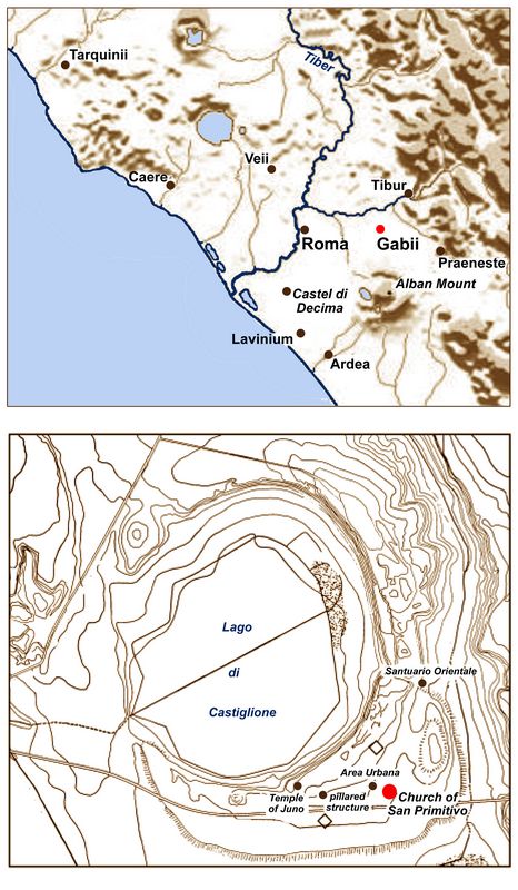
The city of Gabii is located 12 miles east of Rome, at the edge of two volcanic craters (Lakes Castiglione and Pantano), where it controlled the main road that led from the coast inland (figs.1-2). The archaeological pr
 oject “Gabii after the Romans” aims to investigate the
development of the city of Gabii during Late Antiquity and the Middle
Ages (4th-13th c. CE). This period is one of great change, where the
introduction of Christianity and the banning
of paganism (4th c. CE), the foundation of Constantinople (modern-day
Istanbul, 4th c. CE), and the fall of Rome to the Visigoths (5th c. CE)
led a significant socio-cultural, economic, and political change. This
new socio-economic order resulted in the development of smaller
political entities throughout whole of Italy which interacted with each
other. “Gabii after the Romans” intends to consider the processes of
negotiation, interaction, resilience, and resistance of one small
community within this larger framework of generalized change.
oject “Gabii after the Romans” aims to investigate the
development of the city of Gabii during Late Antiquity and the Middle
Ages (4th-13th c. CE). This period is one of great change, where the
introduction of Christianity and the banning
of paganism (4th c. CE), the foundation of Constantinople (modern-day
Istanbul, 4th c. CE), and the fall of Rome to the Visigoths (5th c. CE)
led a significant socio-cultural, economic, and political change. This
new socio-economic order resulted in the development of smaller
political entities throughout whole of Italy which interacted with each
other. “Gabii after the Romans” intends to consider the processes of
negotiation, interaction, resilience, and resistance of one small
community within this larger framework of generalized change.Fig.1 (top): Location map of Gabii.
Fig.2 (bottom): Plan of Gabii and Lake Castiglione.
Previous work at the site::
Excavations here have taken place since the 18th c. CE, but in 2008 a new project (the Gabii Project) resumed fieldwork at the site under the aegis of the University of Michigan. Large scale excavation has shown that the city emerged in 9th c. BC as part of a long negotiation between different groups, but it declined during the 2nd c. BC due to the growth of Rome’s power.
Very little attention so far has been paid to the development of the site after the Imperial Period (post-3rd CE). Since 2008, substantial traces of Late Antique and Medieval occupation have been uncovered in the southeastern section of the city and preliminary investigations have confirmed a series of substantial restorations of the structures along the road in the 4th, 5th, and 6th c. CE. Probably in the 5th c. CE, a church building (dedicated to the martyr Saint Primitivo) was erected as a result of the establishment of a bishopric at Gabii in the 460s CE. The church was only quickly excavated in the late 1990s, but a detailed study of the structure has yet to be carried out. Sometime after the 6th c. CE, a large ditch (150 m long and ca. 5-7 m wide) was carved through a large section of the eastern part of the ancient city. The function and date of this ditch are still very much unclear, but preliminary C14 testing on a limited sample extracted from the southernmost edge of the ditch suggests that it was re-filled in the 11th c. CE. After this date, scattered occupation around the main road is attested by the presence of so-called “wallettes,” small dry-stone walls of unknown function. These “wallettes” seem to cover a large portion of the southeastern section of the city, but their date and development are also still unclear.
Goals:
1) We aimed to shine new light on the extent and main structures of Gabii in Late Antiquity and the Middle Ages, as well as to detect any changes over time.
2) We intended to investigate further the large ditch discussed above. In particular, we intended to map its depth. We also planned to gather more information about the date of its fill. Until summer 2019, only a limited section (ca. 10 m) in the southernmost section had been explored in detail. A better understanding of its dimension, course, and fill may offer further cues on its function.
3) We aimed to study the so-called “wallettes,” which seem to appear all over the southern part of the settlement. We planned to excavate a section of the city that contains an unknown number of them. The intended goal was to gather more dating materials (diagnostic artifacts) as well as organic elements that can be tested for C14. As for the ditch, a better knowledge of its chronology and composition may provide further information on its function.
 The 2019 season was partially
disrupted by the death of the state officer at the local
archaeological administrative unit, Dr. Musco, which led to
significant delays in the releasing of the permit as well as to
substantial changes to our plan. Permission was not given to excavate
in Area G and I, as stated in our proposal, but we were allowed to
conduct cleaning and recording of archaeological features in the
south-eastern section of the archaeological park.
The 2019 season was partially
disrupted by the death of the state officer at the local
archaeological administrative unit, Dr. Musco, which led to
significant delays in the releasing of the permit as well as to
substantial changes to our plan. Permission was not given to excavate
in Area G and I, as stated in our proposal, but we were allowed to
conduct cleaning and recording of archaeological features in the
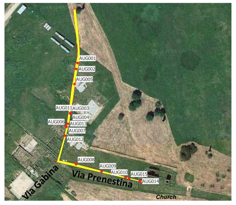
south-eastern section of the archaeological park. Fig.3: Location of the cores in the ditch at Gabii.
This sector includes the Medieval church, which had only been superficially investigated and published in the late 1990s. Thus, a substantial part of our work focused on the recording and studying of this important structure. Coring of the ditch was carried out as planned (see report below), but damage to the local water pipeline hindered our ability to float the collected samples in the field. Processing of the boreholes was carried out at the University of Ravenna, under the supervision of Dr. Cavalazzi. Selected samples will be sent to Beta Analytic for C14 testing.
Methodologies and findings:
Work at Gabii focused particularly on two main features: the coring of the ditch, which still represents a mysterious element in the city’s development, and an in-depth study of the church of Saint Primitivo.
The ditch:
The ditch was cored with a hand-auger set by Michele Abballe (fig.1), who brought to light and examined some recurring layers, fills of the ditch. Work on the ditch was divided into two transects:
- N-S, from the Gabii Project’s base camp towards the center of the Area Urbana
- E-W, from near the center of the Area Urban towards the Church of St. Primitivo.
Preliminary observations made by Abballe on both transects seem to confirm the presence of several layers in the ditch, which often goes as deep as the bedrock. Many of them yielded construction materials (brick and stone fragments), although one recurring layer (SU 2, N-S transect) showed no evidence of artifacts. SU 2 is, however, located in between layers that yielded ancient materials, and therefore requires further investigation. In Transect E-W, a
 new recurring layer (SU 9) appeared
in the boreholes extracted. It is very heterogeneous, orangish in
color, and appears to be composed of small fragments of rocks, mortar,
and other anthropic artifacts. This layer may indicate the presence of
a possible layer of mortar at the base of the ditch, just above the
tufo bedrock (SU 6). As for SU 2, this hypothesis needs to be verified,
perhaps with a larger excavation of the ditch.
new recurring layer (SU 9) appeared
in the boreholes extracted. It is very heterogeneous, orangish in
color, and appears to be composed of small fragments of rocks, mortar,
and other anthropic artifacts. This layer may indicate the presence of
a possible layer of mortar at the base of the ditch, just above the
tufo bedrock (SU 6). As for SU 2, this hypothesis needs to be verified,
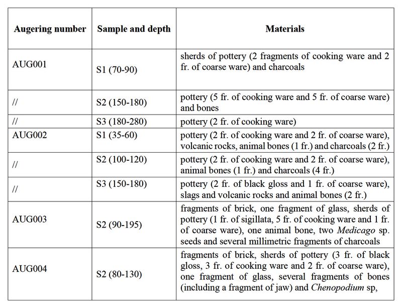
perhaps with a larger excavation of the ditch.Table 1: Preliminary list of finds in the ditch at Gabii.
Finds in the ditch:
Celeste Fiorotto, archaeobotanical expert from the Universities of Ghent and Verona, carried out the processing and preliminary analysis of the finds in the boreholes. This examination was conducted in the facilities at the University of Ravenna using bucket flotation technique. A preliminary list of finds is in table 1.
The church:
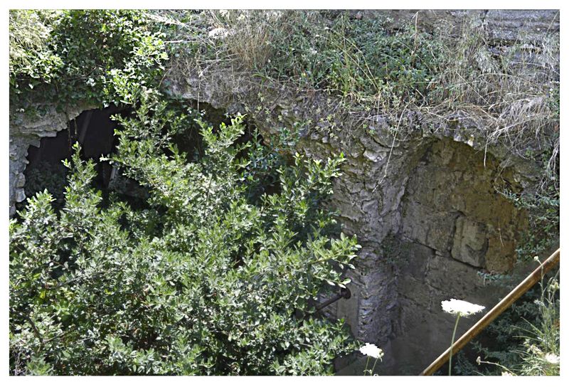
The church (fig.4) was fully documented for the first time since the late 1990s. Up-to-date technology, such as drone photography and 3D modeling, was applied to the study of the building. Documentation was also carried out in order to detect and assess the state of preservation of the church, which appears to be precarious. Additionally, the team partially cleaned and photographed some of the old trenches excavated in the late 1990s. This work was conducted to clarify the extent of previous field archaeological investigations as well as to plan further excavation in the next years. Below is a list of all that was accomplished in the 2019 season:
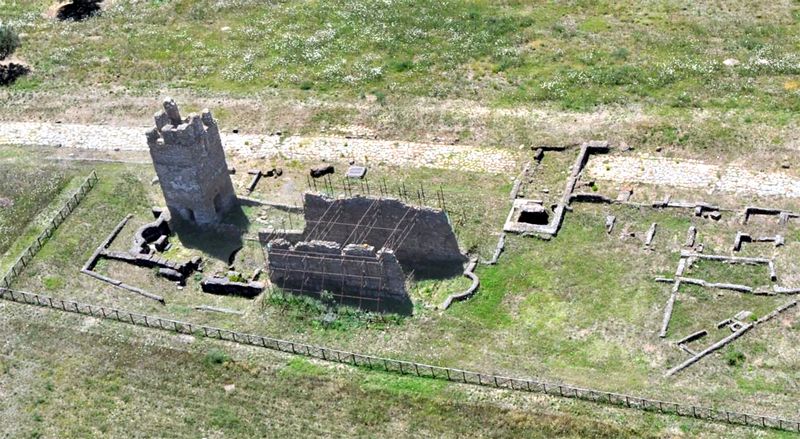
Fig.4: Aereal view of the Church.
1. Drone photos allowed the creation of a full plan of all the structures left. Based on this documentation, we created a 3D model of remains. We also carried out a detailed examination of the standing structures, which includes walls, stratigraphy, as well as its current state of masonry deterioration.
2. The church is an overall in poor state of preservation: the side walls (N and S) are the better preserved in height (ca. 5/6 m) and these were reinforced with iron bars in the 1990s. Structurally, the central- western section of the church seems in precarious conditions, and it certainly necessitates substantial restoration work to allow further study.
Fig.5: Crypt in the church at Gabi.
3. The S and N walls of the church also sit on a pre-existing structure, which was turned into a vaulted room that is now completely underground (fig.5). We were able to recognize as many as 5 vaults which are all collapsed and filled with debris. Work in the 1990s revealed two of those vaults (in the central part of the church), but vegetation has now grown everywhere in the underground room. A tree is now visible in the central part of the room. This is certainly the
 area of the church
in greatest need of conservation work.
area of the church
in greatest need of conservation work.4. Further analysis of the underground room has shown that the N and S walls rest on a pre-existing structure in opus quadratum (probably of Roman origin, given its characteristics). The vaults visible in the 1990s trench rest on pillars (stone) abutting against the opus quadratum walls.
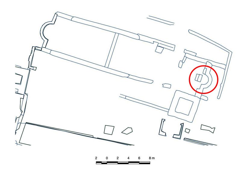
Fig.6: Plan of the Church at Gabii. The position of the apse is marked in red.
5. Further analysis of the church masonry led to the identification of 3 possible reconstructions. A preliminary prospectus of them was made, and Dr. Zoni sketched (by hand) the development of both S and N wa
 lls
sections based on our future observations.
lls
sections based on our future observations.Cleaning of old trenches in the church:
1) The team has produced a map of the eastern apse with a detailed legend of wall stratigraphy and patterns of structural deterioration.
Fig.7: Photo of the two floor levels in the Church at Gabii.
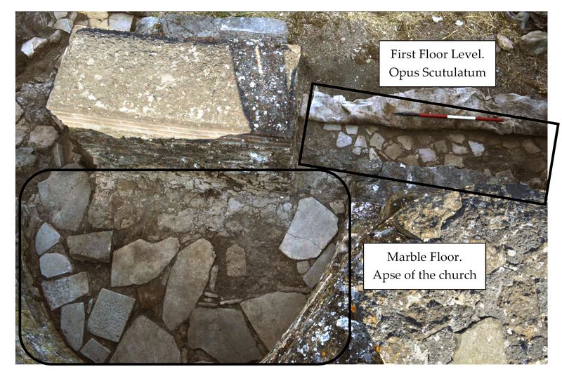
2) Cleaning of the old 1990s trenches has been carried out in various sectors of the church, and particular emphasis was given to the altar area and the western apse (fig. 6). The latter was carried out in order to identify possible traces of a façade, which is now missing. Unfortunately, the area was too small to give any clear conclusion, and more work needs to be done. The uncovering of the altar, on the other hand, has revealed much information on the church. Two floor levels were re-discovered; 1) a marble
 pavement is located in the eastern apse
(fig.7) and 2) a multi-color tile floor (opus scutulatum) covers the
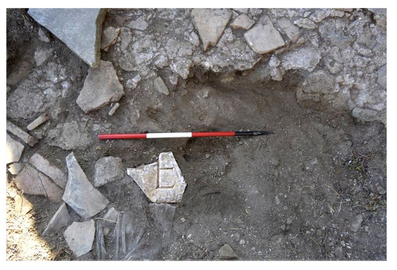
space west of the altar (its full extent is unknown). Further
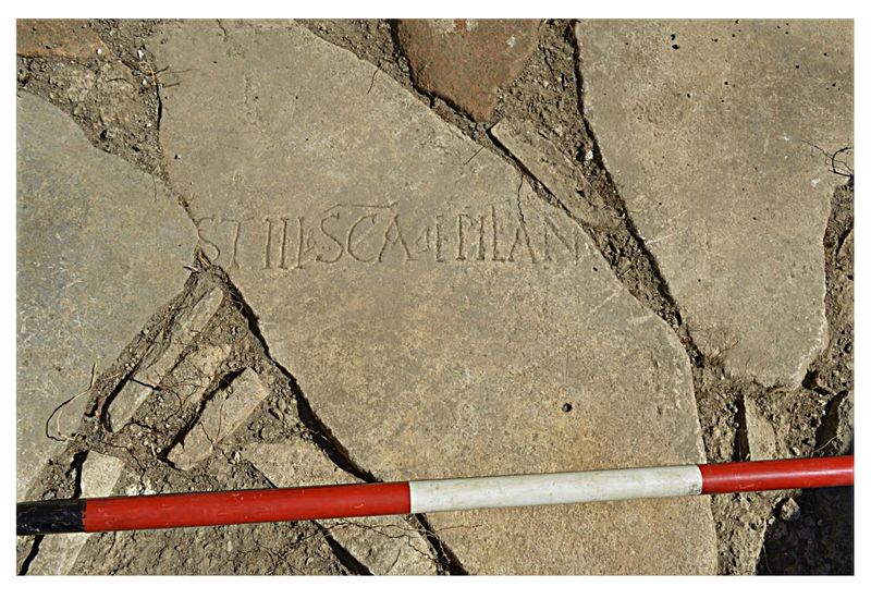
examination of the marble floor revealed the use of spolia, such as a
column base, as well as two fragments of two inscriptions (fig.8). The
longer one, located just east of the altar, mentions a Saint Epifania,
and may be dated to the 5th c. CE (based on a preliminary examination
of the letters) (fig.9).
pavement is located in the eastern apse
(fig.7) and 2) a multi-color tile floor (opus scutulatum) covers the
space west of the altar (its full extent is unknown). Further
examination of the marble floor revealed the use of spolia, such as a
column base, as well as two fragments of two inscriptions (fig.8). The
longer one, located just east of the altar, mentions a Saint Epifania,
and may be dated to the 5th c. CE (based on a preliminary examination
of the letters) (fig.9).Fig.8: Inscription found in the Church at Gabii.
Conclusions and ongoing plans:
Our 2019 season clearly demonstrated that the community at Gabii in the Late Roman and Medieval Periods was very active, and constantly interacted and re-negotiated its relations with the Roman built environment. Our new understanding of the church shows clearly that southeastern sector of the city was already in use as a Christian center as early as the 4/5th c. CE.
Fig.9: Inscription with “Saint Epifania.” Church at Gabii.
More work is needed to clarify the connection between this development and the Roman structures, but the results achieved in 2019 look very promising. Boreholes extracted along the ditch and analysis of the ditch’s fill are the first step to understand the development and function of this feature. A possible mortar layer, for example, may suggest the presence of a built structure within it, but further excavations will be necessary to test this hypothesis.
Dissemination of results:
The team is currently planning a number of publications and conference presentations in the next academic years 2019/2020-2020/2021. In particular, we are currently preparing a final publication of the preliminary work carried out during this summer. Once the analysis of the botanical samples is completed, we will submit this article for review. We are also preparing a review article on previous research, which will be re-interpreted in the light of our discoveries.
Recent Foundation grants: general Archaeology Grants Program w/map
Copyright © 2022 Rust Family Foundation