Rust Family Foundation: Archaeology Grants Program
2019 Field Research in Southcentral Alaska
Principal Investigators: John T. White and Dr. Ted Goebbel
Center for the Study of the First Americans
Department of Anthropology, Texas A & M University
The Americas were the last continental landmasses to be colonized by humans (Goebel et al. 2008; Waters 2019). However, the timing and routes employed during this migration remain unclear. The debate regarding a coastal versus inland (ice-free corridor) migration route into North America is now several decades old (Fladmark 1979; Potter et al. 2018) but continues to attract proponents to both sides (Dixon 2013a; Froese et al. 2019; Potter et al. 2018).
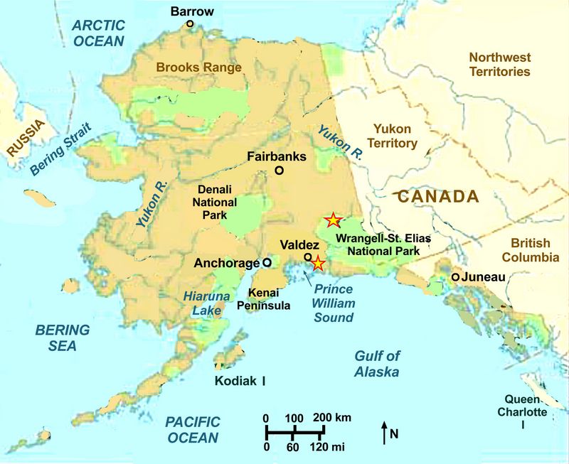
The Center for the Study of the First Americans undertook fieldwork in southcentral Alaska during the summer of 2019 to investigate geologic and archaeological evidence related to the initial human occupation of the region during the late Pleistocene. These investigations were conducted in two parts: excavation of Nataeł Na’, a subsurface multicomponent prehistoric site named for a Native Alaskan placename located in northern Wrangell-Saint Elias National Park and Preserve (Reininghaus 2019) and sediment coring of isolation basins around Prince William Sound (Figs.1,9).
Currently, very little is known about the prehistory of Prince William Sound and southcentral Alaska (Dixon 2013), t
 hough this region would have, by necessity, been important to any coastal migration from
Asia into the Americas. Moreover, the Copper River basin, which is the
primary watershed in the region, may have served to connect coastal and
interior Alaska during the late Pleistocene (see Reininghaus 2019). The
topographic relief present along the outer coast
of Prince William Sound (Figs.1,9) (Kesti et al. 2005) makes it an
ideal area to apply the techniques of Fedje et al. (2018) and McLaren
et al. (2014, 2019) to the reconstruction of regional sea level change.
hough this region would have, by necessity, been important to any coastal migration from
Asia into the Americas. Moreover, the Copper River basin, which is the
primary watershed in the region, may have served to connect coastal and
interior Alaska during the late Pleistocene (see Reininghaus 2019). The
topographic relief present along the outer coast
of Prince William Sound (Figs.1,9) (Kesti et al. 2005) makes it an
ideal area to apply the techniques of Fedje et al. (2018) and McLaren
et al. (2014, 2019) to the reconstruction of regional sea level change.Fig.1: Map of Alaska, showing the locations of fieldwork described in this report..
This methodology was created by decades of painstaking fieldwork by these research teams and has yielded remarkable results, pushing the record of human habitation back to 13,000 calendar years ago (cal BP) or even earlier (McLaren et al. 2018, 2019; Waters 2019) but it has yet to be extensively applied outside of British Columbia (McLaren et al. 2019). The importance of understanding localized sea levels cannot be overstated when attempting to predict the potential of landforms to contain buried Pleistocene-aged cultural materials because the position of the coast would have dictated the environment (Carlson and Baichtal 2015; Fedje et al. 2018; McLaren et al. 2019). Thus, anything other than a thorough and systematic reconstruction of the paleo-landscape is unlikely to result in a properly informed predictive model. The admittedly daunting logistics of such a reconstruction have prevented researchers from addressing questions about the earliest habitation of the southern coast of Alaska to date. This situation requires an immediate remedy.
Previous work at the sites::
The excavations at Nataeł Na’ seek to clarify the age of the earliest occupation of the site, which was located by National Park Service archaeologists in 2016 and preliminarily dated to approximately 12,000 cal BP (Reininghaus 2019), as well as the human behaviors represented by the archaeological record at this site. The sediment coring program, which was continued during the 2021 field season following a delay in 2020 due to the global pandemic, will facilitate the creation of a detailed regional sea-level curve which will be used to create a predictive model identifying landforms with the potential to preserve late Pleistocene-aged archaeological materials (see McLaren et al. 2019). The recovered cores will also provide evidence of glacial dynamics in the Prince William Sound region and may elucidate the local history of deglaciation. Work of this nature has not previously been attempted on Hinchinbrook Island to our knowledge. This project will ultimately expand our understanding of the early human occupation of southcentral Alaska, an important region which has received relatively little archaeological investigation to date.
Current Project (RFF-2019-107)
Goals:
The goals of the excavation at Nataeł Na’ in Wrangell-Saint Elias National Park were to:
1. Conduct limited test excavation to investigate the geologic context of Nataeł Na’ and determine the extent and preservation of the site’s oldest occupation, 12,000 years ago;
2. Recover samples appropriate for radiocarbon dating to confirm the age of the hearth feature in Locality A and establish ages for bracketing strata;
3. Analyze artifacts recovered to assess the technological organization and behaviors represented at this site, as well as the archaeological-complex attribution (i.e. is this a Denali complex occupation or something else?).
The goals of the coring program in the Prince William Sound region were to:
1. Determine the optimal locations to recover sediment cores appropriate for diatom analysis designed to determine the timing and extent of local sea-level dynamics;
2. Recover sediment cores from targeted basin lakes that will inform the necessary extent of the coring program in successive field seasons;
3. Analyze the recovered cores for environment-specific diatoms as well as varve sequences to establish deglaciation and sea-level change events to inform the full coring program.
Methodology:
Nataeł Na’ Excavations
The excavations at Nataeł Na’ were conducted using hand tools and standard scientific archaeological techniques. Spatial data representing site context and distribution were recorded using a total station. Analysis of the recovered lithic artifact assemblage shows that this assemblage contains only limited technologies diagnostic of specific archaeological complexes. It does, however, inform upon the behaviors performed by the site’s ancient occupants.
Prior to the initiation of the project we supplied the NPS with a detailed research design including expected field dates and excavation methodologies. We applied for and received a permit, overseen by the Superintendent of Wrangell-Saint Elias National Park and Preserve and the Alaska Department of Natural Resources, under the auspices of the Archaeological Resource Protection Act. NPS archaeologists and heritage managers conducted government-to-government consultations with local representatives of the Ahtna Corporation to secure Native Alaskan approval of our permit, as required by the Alaska Native Claims Settlement Act. These consultations were resumed during 2020 and 2021 to discuss giving the site an official name. This resulted in the site being named Nataeł Na’ after a nearby traditional placename. Our agreement with NPS also detailed the treatment of samples intended for destructive analysis, including charcoal samples for radiocarbon dating..
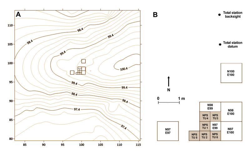
TThe excavation of Nataeł Na’ expanded upon the test excavations conducted by the National Park Service archaeologists during 2016-2018. The existing trench, composed of six connected 50x50-centimeter test units, was enlarged to create a 2x2-meter block excavation. Additionally, two outlying 1x1-meter excavation units were opened to the north and west of the main excavation block (fig.2) to investigate the lateral extent of the buried cultural materials and localized site stratigraphy. Each 1x1-meter unit was excavated using trowels and fine hand tools. Excavation units were divided into quadrants that were excavated individually to improve the
 precision of spatial data associated with recovered artifacts.
Fig.2: (A) Topographic map of Nataeł Na’ and the landform the site is located on. Measurements are in meters and relative to the site datum.
(B) Planview of the excavations at Nataeł Na’. NPS test units are marked in tan.
Units were excavated in arbitrary 5-centimeter levels within natural stratigraphic units and truncated as needed to maintain the stratigraphic association of artifact deposition. After encountering the primary cultural component, we switched to 2.5-centimeter levels and continued to confine excavation to natural stratigraphic levels. Artifacts recovered in situ were mapped in place in three dimensions using a Leica total station and all results were recorded by individual excavation unit. When artifacts were uncovered without significant disturbance surveyors’ compasses were used to record the three-dimensional orientations (trend and plunge) to assist our analysis of the site context and depositional integrity. All recovered sediments were dry-screened through 1/8-inch mesh and any artifacts recovered from the screen were recorded according to elevation range, excavation unit, quadrant, and stratigraphic level. Samples of suspected tephra were collected as they were encountered, and each identified stratigraphic unit was sampled for sedimentological analysis prior to backfilling the excavation. All artifacts were assigned field specimen (FS) numbers, bagged with associated spatial information recorded on paper tags, and taken to Texas A&M for accessioning and analysis
Charcoal samples recovered for radiocarbon dating were transferred directly from the sediment matrix to envelopes of aluminum foil, using hand tools to minimize contact with excavators’ skin. These samples were recorded and assigned FS numbers as described above. The envelopes were sealed in artifact bags for transport back to Texas A&M. We selected seven samples, representing three stratigraphic layers and recovered from a variety of elevations, for radiocarbon dating. These samples were chosen based on their confident association with individual stratigraphic layers and cultural materials. Radiocarbon samples were sent to the Center for Applied Isotope Studies at the University of Georgia to be assayed using accelerator mass spectrometry. All samples were pre-treated using the Acid-Alkali-Acid method and prepared using the standard AMS methods of Vogel et al. (1984). Resulting age estimates were calibrated using the IntCal13 curve described by Reimer et al. (2013).
Three tephra samples were also recovered during excavation. All were located in the upper sediments, either within the modern O-horizon or close to the O/A contact in Stratum 1. These samples have been sent to Dr. Stephen Kuehn at Concord University for analysis. We initially hypothesized that they represent the north lobe of the White River Ash derived from an eruption of Mount Churchill dating to approximately 1750 cal BP (Lynch et al. 2018). Four micromorphology samples were also recovered during the excavations and have been sent to Dr. Lindsay DiPietro at Baylor University to identify sedimentological and pedogenic processes impacting the formation of the site. One sample may also contain remnants of the presumed hearth feature, and thus may serve to confirm the processes responsible for the creation of this feature.
All lithic artifacts were gently washed in warm water to remove major accumulations of sediment still adhered to their surfaces. A soft-bristled toothbrush was used to break up cemented sediments. Thin layers of fine sediment were left adhered to the artifacts to avoid removal of residues that could prove useful to successive analyses. All artifacts were counted and weighed using a digital scale according to the NPS curation standards. Lithic tools and debitage were visually analyzed at Texas A&M. Each artifact was assigned to a tool type or reduction stage based on size and morphology using the methods described by Andrefsky (1994, 2005, 2009) and Sullivan and Rozen (1985). Raw material was determined for each artifact based on visual analysis. Any artifacts recovered in direct association were analyzed to determine if they refit together. Once all artifacts were accessioned refit analysis was conducted on the full assemblage, including materials recovered during the 2016-2018 NPS excavations.
Sediment Coring:
Optimal coring locations were determined by first examining the region on USGS topographic maps obtained through the USGS online map locator system. These areas were also examined using Google Earth when resolution allowed. We sought to locate isolation basins likely to preserve sediment columns containing diatoms indicative of marine transgression and regression events. Upon arriving in the area in June we performed pedestrian reconnaissance to determine the accessibility of individual basins and the best locations along the banks to stage our coring equipment and any recovered cores.
Sediment coring was accomplished using a five-centimeter-diameter Livingstone square-rod piston coring device. We recovered cores from silted-in basins and the banks of extant ponds and lakes this season. The Livingstone corer is manually operated and allows for the recovery of cores in segments of up to one meter. This coring system has the advantage of being portable, adjustable, and is operated by hand, which allowed us to recover cores from basins which are not directly accessible by vehicle.
The Livingstone coring system is operated by manually inserting a tube with an integral piston and attached drive-rod into the sediments of a lakebed or other coring location. The drive rod can be extended as much as necessary by adding additional segments to continue coring through deeply stratified sediments. The drive rod and piston ensure that sediments are only recovered from the desired depths and significant portions of the cores are not lost to suction during recovery (Myrbo and Wright 2008). The presence of organic and mineral debris as well as vegetation near the shores of the basins we selected for coring, however, impeded the progress of the core tube through the sediments, and we had to recover cores in segments shorter than one meter in most cases.
All recovered sediments were immediately wrapped in cellophane and enclosed in PVC core boxes, which were then thoroughly sealed with duct-tape for transport back to Texas A&M University. Detailed notes were recorded throughout the process, and all cores were thoroughly labeled to ensure proper identification and analysis.
Preparation and analysis of the sediment cores is ongoing and will be completed using the methods described by Battarbee (1986). Each core must be sub-sampled, which involves splitting the core and removing sediments form the center to ensure minimum possible contamination. The resulting sediments are treated with heated weak acid to separate the diatoms from the matrix. The resulting fraction is then centrifuged to fully separate the diatoms from other materials. The remaining liquid may require sonication before microscope slides can be successfully prepared. Once the sample slides are prepared, abundance of diatom species is counted under microscopic magnification.
Findings:
Results of Nataeł Na’ Excavations:
Our excavations at Nataeł Na’ expanded on the initial testing performed by the NPS archaeologists during the 2016-2018 field seasons (Reininghaus 2019). We excavated a 2x2-meter block that encompassed all of the NPS test units except TU 5, which extended out from the western wall of ou
 r excavation block (Fig.2B). Additionally, we excavated 1x1-meter units to the north
and west of the main block to determine the lateral extent of cultural
deposition. We terminated excavations upon reaching the basal deposits
of coarse grey sand, which we interpreted as glacial outwash (see also
Reininghaus 2019), which occurred between 65 and 80 centimeters below
the ground surface.
r excavation block (Fig.2B). Additionally, we excavated 1x1-meter units to the north
and west of the main block to determine the lateral extent of cultural
deposition. We terminated excavations upon reaching the basal deposits
of coarse grey sand, which we interpreted as glacial outwash (see also
Reininghaus 2019), which occurred between 65 and 80 centimeters below
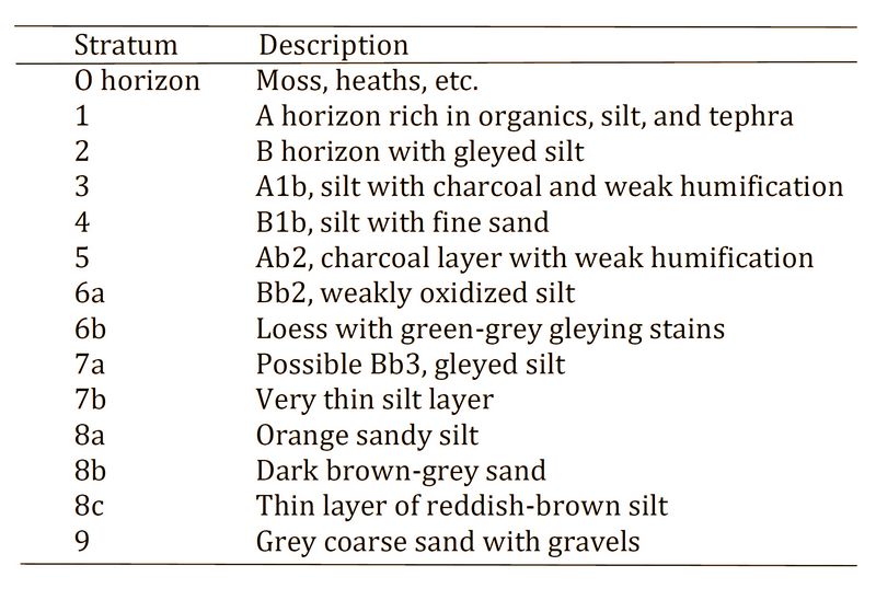
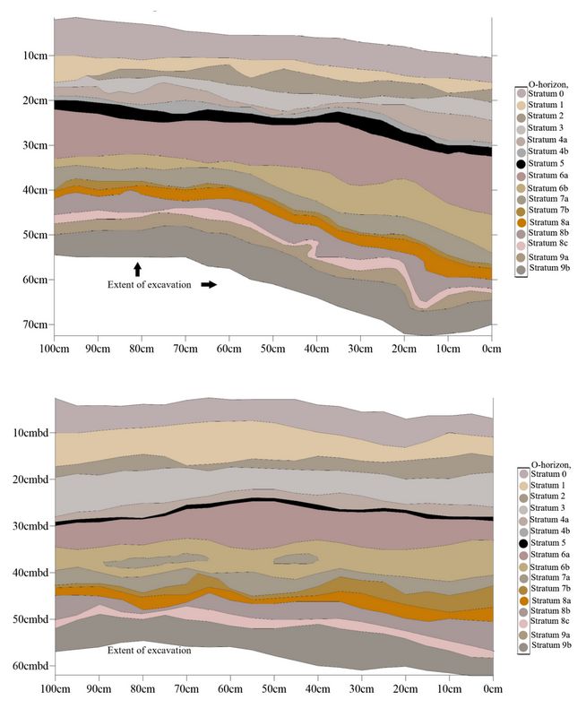
the ground surface.Table 1: Stratigraphic descriptions designated during 2019 fieldwork.
We identified 14 discreet sediment layers (table 1) in the excavation profile at Nataeł Na’, as did the NPS archaeologists during their initial testing (Reininghaus 2019). However, we interpreted these profiles as representing several periods of stability and soil development which were not reported from the NPS testing program.
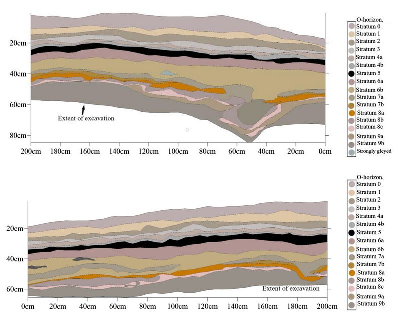
Fig.3 (top): Profile of the east wall of the main excavation block.
Fig.4 (bottom): Profile of the north wall of the main excavation block.
Below the thick O horizon, which has developed under modern boreal forest conditions, we identified modern A and B horizons composed primarily of eolian silt. Below this is a buried A horizon whi
 ch
has undergone low levels of humifaction and an associated B horizon
which contains a small proportion of fine sand within a matrix of
eolian silt. We also identified an intact buried surface that displays
evidence of a forest fire overlying a stable loess package that has
experienced moderate oxidation and intermittent weak gleying. Below
these layers is a series of interspersed silts and sandy silts which
may represent another buried surface and associated B horizon that
overlies the basal sands. We interpret the sediments identified in this
profile as primarily eolian, with the exception of the basal stratum
(Stratum 9) which we believe to be glacial outwash. These strata are
illustrated in figs.3-6.
ch
has undergone low levels of humifaction and an associated B horizon
which contains a small proportion of fine sand within a matrix of
eolian silt. We also identified an intact buried surface that displays
evidence of a forest fire overlying a stable loess package that has
experienced moderate oxidation and intermittent weak gleying. Below
these layers is a series of interspersed silts and sandy silts which
may represent another buried surface and associated B horizon that
overlies the basal sands. We interpret the sediments identified in this
profile as primarily eolian, with the exception of the basal stratum
(Stratum 9) which we believe to be glacial outwash. These strata are
illustrated in figs.3-6.Fig.5 (top): Profile of the east wall of N97E97.
Fig.6 (bottom): Profile of the south wall of N100E100.
Radiocarbon dates:
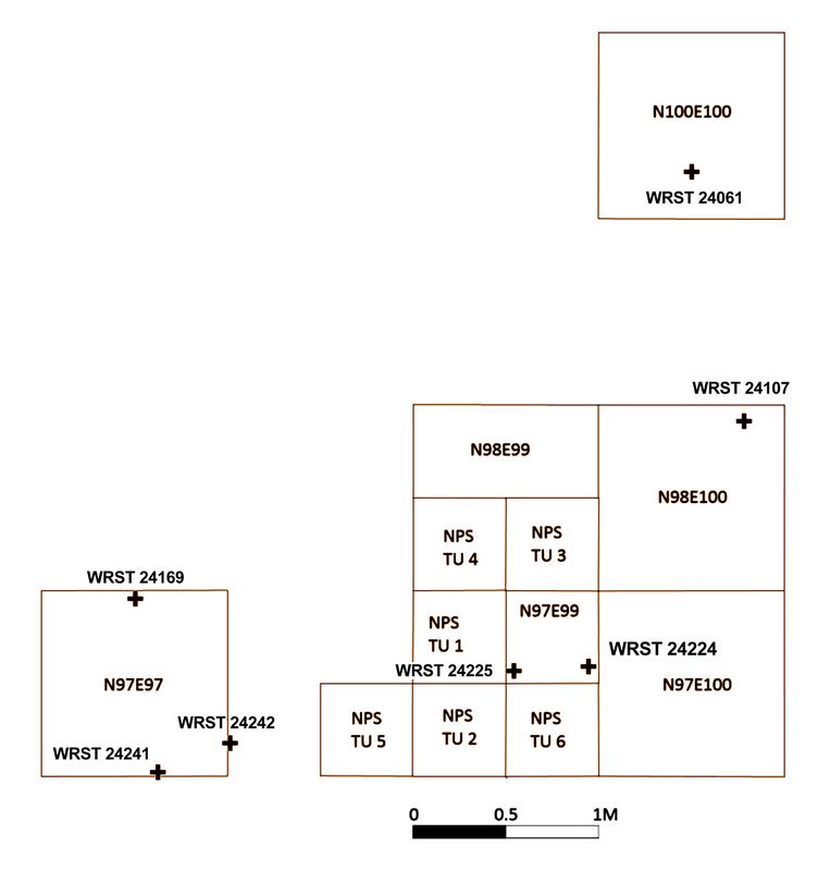
We recovered charcoal samples opportunistically throughout the course of the excavation, attempting to gather sufficient samples to date every discrete sediment layer we encountered as necessary. These efforts yielded a total of 35 charcoal samples, though they represent only four of the identified sediment layers. To date, seven have been dated by the Center for Applied Isotope Studies at the University of Georgia. Although the samples were recovered from across the excavation block (fig.7), the age estimates they yielded are in stratigraphic order (table 2).
Table 2: Radiocarbon Dating of Samples Recovered during the 2019 Field Season.
While we did not locate any obvious remnants of the presumed hearth excavated from TU 1 by the NPS archaeologists (fig.7), we were able to recover charcoal samples from the strata above and below the feature. We also recovered one charcoal sample, WRST-24225, from previously unexcavated sediments adjacent to the presumed hearth feature and in the same stratigraphic unit. The age estimate derived from this s
 ample
(11,400-11,768 cal BP) falls within the date range established for the
hearth feature by the NPS testing program. The overlying strata have
yielded dates ranging from the terminal Pleistocene to
the late Holocene in stratigraphic order. Portions of each charcoal
sample were sent to Auréade Henry of the French National Center for
Scientific Research in Nice for identification to species, suggesting
that the site was not yet located in a boreal forest environment during
the first two occupations.
ample
(11,400-11,768 cal BP) falls within the date range established for the
hearth feature by the NPS testing program. The overlying strata have
yielded dates ranging from the terminal Pleistocene to
the late Holocene in stratigraphic order. Portions of each charcoal
sample were sent to Auréade Henry of the French National Center for
Scientific Research in Nice for identification to species, suggesting
that the site was not yet located in a boreal forest environment during
the first two occupations. Fig.7: Distribution of dated charcoal samples.
Lithic artifacts:
Our excavations recovered a total of 848 lithic artifacts. Of these, five were diagnostic of specific lithic technologies including two biface fragments (fig.8, items C and F), a broken scraper (fig.8, item J), a microblade fragment (fig.8, item Q), and a burin spall (fig.8, item P). The bifaces and the scraper were manufactured on locally available basalt, which is by far the most common lithic raw material recovered from Nataeł Na’, while the microblade and burin spall were manufactured on a cryptocrystalline silicate (CCS) and are some of the only examples of this material recovered from the site. We also recovered a small, sub-rounded green pebble of unknown material. It is unclear if this object is of cultural origin, although it is the only example of this material present in the Nataeł Na’ assemblage and may represent an exotic stone transported to the site by humans.
Additionally, we recovered 843 pieces of lithic reduction debitage. This included eighteen pieces of obsidian, four chert flakes, one quartzite flake, and one flake manufactured on an unidentified crypto-crystalline silicate material. All artifacts manufactured on exotic lithic raw materials were recovered from Stratum 6 and excavation unit N97E97, the western outlying unit. All other lithic artifacts were manufactured on local basalt. Though a limited number of primary reduction flakes and cortical spalls are included in the assemblage, the majority of the debitage is related to secondary and tertiary reduction. The assemblage also contains one blade-like flake and three biface thinning flakes. No artifacts were recovered from the northern excavation unit, N100E100. All field specimens recovered from this unit were charcoal or sediment samples.
Further lithic analysis of the assemblage recovered from Nataeł Na’, including refitting of lithic artifacts, was undertaken at Texas A&M University in spring and summer 2020, and included the assemblage recovered from the initial NPS testing in the 2016, 2017, and 2018 field seasons. This analysis has helped to elucidate the extent of post-depositional disturbance present at the site, thereby clarifying the quantity and integrity of the buried components, including the earliest occupation of the site. This has also more clearly demonstrated the association of the cultural materials recovered from different strata and confirmed that they truly represent separate occupations. Obsidian was geochemically analyzed by Jeff Rasic of the National Park Service to determine the source(s) of this lithic raw material. All obsidian recovered from Nataeł Na’ have been assigned to the Wiki Peak source near the Canadian border. We also conducted geochemical analysis of a sub-set of the basalt artifacts and determined that at least four separate basalt types are present, though at present we cannot connect them to a specific geologic source.
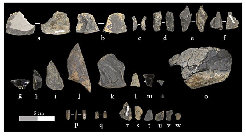
Fig.8: Artifacts from Component 2 (a, c-q) and Component 1 (r-w): (a) early-stage biface fragment, (b) early-stage biface fragment recovered from rodent-burrow cast, (c) indeterminant-stage biface fragment, (d) mid-stage biface fragment, (e-f) late-stage biface fragments, (g) graver/notch, (h) scraper/adze fragment, (i-j) side scraper fragments, (k) retouched flake, (l, n) utilized flake fragments, (m) utilized flake, (o) reconstructed flake core with spalls refit, (p) burin spall, (q) retouched microblade fragment, (r) cortical spall, (s, v-w) biface-reduction flakes, (t-u) flake shatter.
A single basalt flake was recovered from the screen in material associated with Stratum 1. It is unclear if this flake was recovered from original depositional context, or if it perhaps relates to the NPS test excavations in previous seasons. Strata 2 and 3 were culturally sterile.
Stratum 4 yielded eight field specimens. Two were debitage recovered from the western-most outlying excavation unit, N97E97. Two other pieces of debitage were recovered from N97E99, the southwestern excavation unit of the 2x2-meter block. This unit was composed of a single, isolated quadrant in the northeastern corner. The remainder of N97E99 was previously excavated as NPS test units 1, 2, and 6. A single piece of frost-shatter was recovered from this stratum, located on the boundary between N97E99 and N97E100. Finally, stratum 4 also yielded one piece of debitage and a biface-thinning flake recovered from unit N97E100. Additionally, a single basalt cortical spall was recovered in the screen from materials assigned to Stratum 4. Stratum 5 did not yield any cultural materials, though we did recover numerous charcoal samples from this level.
Stratum 6 contained the majority of the cultural assemblage, including all four tools and the unidentified green pebble (Fig.8). This stratum yielded 632 pieces of debitage, a single biface-thinning flake, 15 pieces of suspected fire-cracked rock, a thermal spall, four pieces of frost-shatter, and two fragments of unidentified bone, one of which was burned. These bone specimens were not recovered in association with the presumed hearth feature excavated by the NPS archaeologists during initial testing. They were recovered in association with lithic artifacts, but it has not been definitively demonstrated that these bones are associated with human activity. Stratum 6 also yielded four pebbles of unknown origin. Three of these specimens are granite, which does not occur naturally at the site. While these are not definitively cultural, they are larger than any of the observed clasts of other raw materials occurring in this stratum. While the artifacts recovered from Stratum 6 were recovered from across the excavation block, the greatest density of artifacts was concentrated in excavation unit N97E99.
Stratum 7 contained one charcoal sample and 56 field specimens including materials recovered from the screen. Of these, one was a fragment of a blade-like flake, and 132 were debitage. The remaining item recovered from Stratum 7 was a piece of frost-shatter. The greatest density of artifacts was located in excavation unit N97E99, as in Stratum 6.
Stratum 8a contained only two field specimens in situ. One was a piece of reduction debitage and the other was a piece of frost shatter. Both of these specimens were recovered from excavation unit N97E100. Three basalt flakes were also recovered in the screen from sediments associated with Stratum 8a, one from unit N97E99 and two from N98E99. Stratum 8b was sterile of cultural materials.
Stratum 8c is a thin layer of eolian silt that conformably overlies the basal sands. Though this stratum is intact, like the overlying strata they have experienced significant solifluction. This stratum yielded four charcoal samples and a sediment sample in addition to 19 pieces of debitage. Four of these were recovered from excavation unit N98E99, six from N97E100, a single flake and a piece of FCR were recovered from N97E99, and the remaining seven pieces of debitage were recovered from the western excavation unit, N97E97. A single thermal spall was also recovered from stratum 8c in unit N98E99.
Stratum 9 represents the basal sands. These sediments are culturally sterile. This stratum is sub-divided in some excavation units into a fine upper layer, 9a, and a coarse lower layer, 9b, which is visible at the base of the entire excavation. These sands contain 5-15% rounded and sub-rounded gravels by volume.
Coring Results:
We successfully recovered cores from five mainland locations near the municipality of Valdez, Alaska (fig.9). Two were small isolation basins west of Mineral Creek, to the northwest of Valdez. The remaining three locations were along the western shore of Robe Lake, a large basin lake to the east of Valdez.
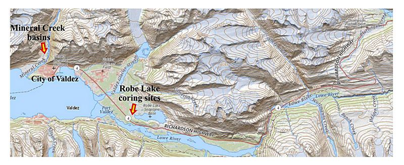 Fig.9: Location of coring sites around Valdez.
Core 1 was recovered from a silted-in kettle pond, now a marsh, west of Mineral Creek. We recovered approximately 80 centimeters of sediment from our first drive, which were primarily peat deposits with fine grey silt at the base. A second drive yielded roughly 30 centimeters of grey silt. The third drive was unsuccessful, but the fourth, fifth, and sixth drives yielded short (20-30 centimeter) sections of interbedded grey silt and peat lenses. One such section from the fifth drive bulged out beyond the core box during the extrusion of the core. This was repositioned to allow the core box to be properly sealed. The sixth drive yielded a transition from silt to sand roughly ten centimeters above the base. The seventh and final drive yielded a section approximately 47 centimeters in length. This section was entirely composed of grey silty sand with small gravels. An eighth drive was attempted but did not recover any sediment. We encountered something solid, likely a small boulder, that precluded further coring at this location.
Core 2 was recovered from a small, perched isolation basin containing a heavily vegetated pond. This basin was located on a small hill rising above the surrounding coastal plain. The bank was covered with thick growth of sphagnum moss which extended out onto the surface of the pond, making it very difficult to find solid footing. The bed of the pond was soft and unstable, making it equally difficult to core from within the pond. A suitable location was identified at the western edge of the pond and a core approximately 85 centimeters in length was recovered in four drives. Underlying a thick organic layer at the top, this core contained brown, organic-rich sandy silt that graded to grey-brown sandy silt at about 30 centimeters from the base. The moss comprising the bank at our recovery site continued to sink with the recovery of each section, and we were unable to reach the basal sands at this location.
Core 3 was recovered from a heavily vegetated marsh west of Robe Lake. This core was 176 centimeters in total length and required seven drives to fully recover. This core was composed of fine grey silt with minor clay content. Two thin peat lenses were recovered between depths of 25 and 50 centimeters. Below approximately 60 centimeters the silt became increasingly coarse, with inclusions of fine sand. This material became progressively less consolidated and was heavily saturated upon recovery. After the seventh drive we encountered a solid object or heavily cemented surface that precluded further coring.
Core 4 was recovered from a second location west of Robe Lake. This core was taken directly through the floating moss that covers the marsh on the western edge of the lake. Core 4 was 160 centimeters in length and required twelve drives to recover. The first several centimeters of the core were moss and rootlets. Below that was roughly one meter of interbedded fine grey silts with clay and lenses of peat ranging from two to six centimeters thick. We encountered a decaying piece of wood at a depth of approximately 45-50 centimeters but were able to core through it. At 111 centimeters depth we observed a transition to grey silty sand with rounded gravels. At a depth of 119 centimeters there was a thin layer of greyish-brown silt that quickly transitions back to grey silty sand.
Core 5 was recovered from our third and final location in the marsh at the western edge of Robe Lake. This core was 175 centimeters in total length and required fourteen drives to fully recover. The first several centimeters of the core were moss and roots. Below this the core contained interbedded grey silt with clay and peat lenses. At a depth of 61 centimeters there was a band of grey sand that transitioned quickly back to silt with interbedded peat layers. At approximately 135 centimeters the silt and clay transitioned to basal sand with gravels. Though the results of the diatom analysis are not yet complete, initial examination of the cores during recovery suggests that the region around Valdez experienced significant glaciation, likely during the late Pleistocene. Several cores yielded gritty, dark grey sand at the base of the stratigraphic column. These materials closely resemble glacial outwash deposits known from numerous locations across Alaska. The depth of the overlying sediment, including the development of thick peat deposits in several basins, suggests that the glacial retreat which deposited these sediments occurred in antiquity, though these sedimentological transitions have not yet been directly dated. Diatoms are expected to be present in the fine sediments that form the majority of the cores. However, diatoms are likely to be absent from the basal sands, which we interpret as originating from a glaciofluvial context.
We sampled each core at numerous locations for diatom analysis, generally following the methodology of Battarbee (1986). After processing, these samples were examined under magnification up to 600x using light microscopes in the Palynology Laboratory at Texas A&M University’s Department of Anthropology. All identified genera are diagnostic of somewhat acidic, freshwater environments, as would be expected in an environment dominated by coniferous forests. We did not identify any saltwater genera, or any significant changes in diatom communities by elevation within any of the cores.
Conclusions:
Discussion of Nataeł Na’ Excavations
Our excavations at Nataeł Na’ yielded several significant results. The results of our radiocarbon dating program suggest that the initial estimates of the age of the presumed hearth feature (Reininghaus 2019) are correct. Additionally, the cultural materials recovered from Stratum 8c appear to represent an earlier occupation of the site, which we have dated to ~13,000 cal BP. While these dates were derived from dispersed charcoal, one piece was in direct contact with a basalt flake fragment and Stratum 8c is sealed, meaning it has maintained stratigraphic integrity since the late Pleistocene. Our refit analysis did not locate any refits between strata, so we believe that 8c retains its stratigraphic integrity despite evidence of cryoturbation. This find represents the earliest culturally affiliated date presently known from the state of Alaska south of the Alaska Range. We also recovered evidence suggesting that there may have been successive occupations of the site during the deposition of the loess package containing the primary cultural component. Future excavations at the site may one day elucidate this possibility.
The late Holocene age estimate for Stratum 5 likely represents a minimum date for the last use of this locus of the site prior to the Holocene, although it is not entirely clear if the few artifacts recovered above this layer represent a later occupation or if they have been translocated by turbation processes. We initially believed that Stratum 5 separated the Pleistocene occupation of the site from the mid-Holocene occupation identified by the NPS archaeologists at Locality B (Reininghaus 2019), some one hundred meters to the northeast. However, a charcoal sample recovered from this presumed ancient surface dated to approximately 1,300 to 1,390 cal BP, some 1,700 years younger than the age estimates of the Holocene occupation at Locality B (Reininghaus 2019). Thus, the few artifacts we recovered from Stratum 4 may represent a fourth occupation of the site.
We were successful in recovering a charcoal sample from sediments adjacent to the presumed hearth feature excavated by the NPS archaeologists during their initial testing. This sample yielded an age estimate that falls within the range established by the initial NPS testing program at one-sigma. These results appear to confirm the initial age estimates for the occupation associated with the hearth feature. Our efforts to determine the integrity of the site context have also helped to clarify the history of occupation at Nataeł Na’, and appear to confirm that the cultural materials recovered from Stratum 8c represent a distinct late Pleistocene occupation.
We also sought to determine the lateral extent of the cultural materials associated with each occupation of the site. We were partially successful in this effort. It is unclear how far to the east deposition of cultural materials extends, but we successfully determined that the cultural materials do not extend significantly to the north of the initial NPS test trench. They do extend to the west at least two meters beyond the test trench, possibly farther. Cultural materials most likely extend to the south as well, though these would be in secondary depositional context due to the slope of the landform on which the site is located.
It appears that Locus A at Nataeł Na’ was occupied at least twice, probably three times, and potentially even four times (though only three occupations are represented at Locus A). Stratum 8c is a thin layer of eolian silt that conformably overlies the basal sands of Stratum 9. Stratum 8c is less than two centimeters thick in most areas, and its contacts with underlying Stratum 9 and overlying Stratum 8b are both sharp and distinct despite being wavy in many areas due to solifluction. Stratum 8c does not appear to have undergone significant pedogenic processes. This suggests rapid deposition and subsequent burial by the overlying eolian material, which would result in the stratum and any cultural materials contained within it being rapidly sealed. While there is evidence of cryoturbation in the lower levels of Nataeł Na’, it does not appear that Stratum 8c experienced significant bioturbation which may have impacted overlying strata to some degree (Reininghaus 2019).
The artifacts recovered from Stratum 8c may have undergone some post-depositional movement but remain confined within an intact natural stratigraphic layer, in association with well-preserved charcoal. This suggests that the age estimates derived from the associated charcoal accurately represent an occupation predating the creation of the presumed hearth feature in Stratum 6. The dates associated with the cultural materials recovered from Stratum 6 indicate that there was at least one occupation post-dating the deposition of Stratum 8c. We believe that the dates derived from the hearth feature excavated by NPS archaeologists represent a second occupation of Nataeł Na’, and that cultural materials deposited during this occupation experienced post-depositional disturbance from solifluction. This has resulted in displacement of artifacts into Strata 7 and 8a, as well as throughout Stratum 6.
The assemblage recovered from Nataeł Na’ does not contain tools indicative of butchering activity and is composed primarily of unmodified debitage. There were essentially no faunal remains recovered from the site during the 2019 excavations. While the acidic nature of the soils which developed following the colonization of the region by boreal forests during the Holocene may have led to differential preservation of lithic versus osseous artifacts, the extant assemblage is suggestive of tool repair and manufacturing activities. The presence of the presumed hearth feature may suggest limited cooking activities as well, particularly in light of the burned bone recovered during the NPS test excavations (Reininghaus 2019). This evidence suggests that the site was occupied for short periods of time and used primarily as a special-task camp. Its position adjacent to the shoreline of Glacial Lake Ahtna (Reininghaus 2019) indirectly supports this interpretation, as it would have provided quick access to the resources of the surrounding uplands as well as those of the lake itself. We tentatively interpret this site as a seasonally occupied logistical camp for hunting, fishing, and/or gathering, and possibly the procurement of basalt nodules from nearby Tanada Creek. The presence of the single microblade fragment suggests that the ~12,000 cal BP occupation at Nataeł Na’ can be assigned to the Denali Complex, though further confirmation during possible future excavations will strengthen this conclusion.
Discussion of Coring:
Geomorphological evidence present in our initial cores suggests that the mainland around Prince William Sound was covered by the advance of the continental ice sheets during the Last Glacial Maximum. Our initial results appear to confirm the presence of glaciers in the lowlands around Valdez, although we have not dated their retreat from that region. The presence of glacial outwash sediments in isolation basins adjacent to the modern coast suggests that glacial ice covered the lowlands that now comprise Prince William Sound during the late Pleistocene. The presence of this ice likely resulted in the isostatic depression of the surrounding lowlands, and the floor of the sound itself may have been inundated by marine transgression at the ice edge as a result (see McLaren et al. 2014, 2019). Identifying the extent and location of the resulting forebulge effect will be critical to future efforts to locate ancient cultural materials in this area. This will be a primary goal of the coring program during the 2022 field season. Diatom analysis failed to locate any species or genera known to inhabit saltwater environments, further suggesting that the lowlands around Valdez were under glacial ice during the Pleistocene and did not experience direct inundation by any localized sea level transgression events.
Analysis of our cores has provided sedimentological evidence of local deglaciation history, and an important baseline upon which to base future coring efforts. Further coring efforts were conducted on Hinchinbrook Island in Prince William Sound during 2021. These cores did not contain glacial outwash sands, but also did not contain diatom communities diagnostic of sea level transgression. This evidence suggests that large portions of the southcentral Alaskan coast remained covered by glacial ice through much of the Pleistocene. Additionally, the sea level hinge (McLaren et al. 2014; Shugar et al. 2014) may have been located further south of the modern outer coast than initially hypothesized.
Concluding Thoughts:
Southcentral Alaska is a vast and remote region that has received relatively little archaeological research attention to date (Dixon 2013). This is partially due to the dauting logistics of working in the region, and partially to the long-held assumption that the region was confined beneath glacial ice until the early Holocene (Dyke 2004; Kaufman and Manley 2004). As new studies continue to reveal the early availability of the Pacific coast at the end of the Pleistocene for human settlement (Darvill et al. 2018; Froese et al. 2019; Lesnak et al. 2018) and the probability of emergent coastlines preserving Pleistocene-aged deposits (McLaren et al. 2014, 2019; Potter et al. 2018; Shugar et al. 2014), it will become increasingly important to thoroughly investigate these regions. This research represents the first step in initiating such investigations.
Future Research and Plans:
Our results, particularly the obsidian sourcing, will inform future studies related to the transport and procurement of high-quality lithic raw materials in southcentral and interior Alaska as well as the connection of early sites south of the Alaska Range to known sites of similar age in the Tanana River basin and the interior. Our efforts to characterize differences in intra-site basalt use may prove useful in interpreting settlement and mobility patterns of ancient hunter-gatherers exploiting lithic-rich landscapes like southern Alaska in the future.
Results from the excavation of Nataeł Na’ have been presented at the Copper River Basin Symposium held at the Copper Center headquarters of Wrangell-Saint Elias National Park in February 2020, and the Society for American Archaeology Annual Meeting which was held virtually in 2020. They will be presented again at the Annual meeting of the Canadian Archaeological Association in 2022. The final report, including results of the refit analysis, the pyrotechnological analysis, and the tephra analysis, will be submitted to Quaternary International for publication in 2022.
Diatom analysis of the cores recovered from the coastal region around Valdez was facilitated by preparation and sampling training that John White received at the Paleolimnology Laboratory at Indiana State University in December 2019. Additional coring on Hinchinbrook Island and around the city of Cordova will take place during summer 2022. Once these cores have been recovered and analyzed, the local sea-level dynamics can be reconstructed, and a predictive model created using ArcGIS.
References:
Andrefsky, William 1994. The Geological Occurrence of Lithic Material and Stone Tool Production Strategies. Geoarchaeology: An International Journal 9(5): 375-391.
________ 2005. Lithics: Macroscopic Approaches to Analysis (Cambridge Manuals in Archaeology). Cambridge University Press, Cambridge, UK.
________ 2009. The Analysis of Stone Tool Procurement, Production, and Maintenance. Journal of Archaeological Research 17:65–103.
Battarbee, R.W. 1986. Diatom Analysis. In Handbook of Holocene Paleoecology and Palaeohydrology edited by B.E. Birgland. John Wiley and Sons, Chichester, U.K., pp. 527-570.
Carlson, R.J., Baichtal, J.F. 2015. A Predictive Model for Locating Early Holocene Archaeological Sites Based on Raised Shell-Bearing Strata in Southeast Alaska, USA. Geoarchaeology: An International Journal 30: 120–138.
Darvill, C. M., B. Menounos, B. M. Goehring, O. B. Lian, and M. W. Caffee 2018. Retreat of the Western Cordilleran Ice Sheet Margin During the Last Deglaciation. Geophysical Research Letters 45:9710-9720.
Dixon, E. James 2013. Arrows and Atl Atls: A Guide to the Archaeology of Beringia. National Park Service, Shared Beringian Heritage Program.
Dyke, A.S. 2004. An Outline of North American Deglaciation with an Emphasis on Central and Northern Canada. In Quaternary Glaciations - Extent and Chronology. Part II, edited by J. Ehlers, P.L. Gibbard. Elsevier, Amsterdam, pp. 373-424.
Fedje, Daryl, Duncan McLaren, Thomas S. James, Quentin Mackie, Nicole F. Smith, John R. Southon, and Alexander P. Mackie. 2018. A Revised Sea Level History for the Northern Straight of Georgia, British Columbia, Canada. Quaternary Science Reviews 192: 300-316.
Fladmark, Knut R. 1979. Routes: Alternate Migration Corridors for Early Man in North America. American Antiquity 44(1), 55-69.
Froese, Duane, Joseph M. Young, Sophie L. Norris, and Martin Margold 2019 Availability and Viability of the Ice-Free Corridor and Pacific Coastal Routes for the Peopling of the Americas. SAA Archaeological Record 19(3): 37-33.
Goebel, Ted, Michael R. Waters, Dennis H. O’Rourke 2008. The Late Pleistocene Dispersal of Modern Humans in the Americas. Science 319:1497- 1502.
Kaufman, D.S., Manley W.F. 2004. Pleistocene Maximum and Late Wisconsinan glacier extents across Alaska, U.S.A. In Quaternary Glaciations - Extent and Chronology. Part II, edited by J. Elhers and P.L. Gibbard. Elsevier, Amsterdam, pp. 9-27.
Kesti Susan, Milo Burcham, Bruce Campbell, Rob DeVelice, Heather Hall, Carol Huber, Tim Joyce, Dirk Lang, Bill MacFarlane, Dixon Sherman, Ricardo Velarde 2005. Big Islands Landscape Assessment, Cordova Ranger District. Chugach National Forest.
Lesnek, Alia J., Jason P. Briner, Charlotte Lindqvist, James F. Baichtal, and Timothy H. Heaton 2018. Deglaciation of the Pacific Coastal Corridor Directly Preceded the Human Colonization of the Americas. Science Advances 4.
Lynche, Joshua J., Ted Goebel, Kelly E. Graf, Jeffery T. Rasic, Stephen C. Kuehn
2018. Archaeology of the Upper-Most Tanana Basin: Results of a Survey of the Nabesna and Chisana Rivers, East-Central Alaska. Alaska Journal of Anthropology 16(1): 21-43.
McLaren, Duncan, Daryl Fedje, Murray B. Hay, Quentin Mackie, Ian J. Walker, Dan H. Shugar, Jordan B.R. Eamer, Olav B. Lian, Christina Neudorf 2014, A Post-Glacial Sea Level Hinge on the Central Pacific Coast of Canada. Quaternary Science Reviews 97: 148-169.
McLaren, Duncan, Daryl Fedje, Quentin Mackie, Loren G. Davis, Jon Erlandson, Alisha Gauvreau, and Colton Vogelaar 2019. Late Pleistocene Archaeological Discovery Models on the Pacific Coast of North America. PaleoAmerica 5(4).
Myrbo, A. and H.E. Wright 2008. Livingstone-Bolivia. SOP Series. Limnological Research Center Core Facility, Minneapolis.
Potter, Ben A., James F. Baichtal, Alwynne B. Beaudoin, Lars Fehren-Schmitz,
C. Vance Haynes, Vance T. Holliday, Charles E. Holmes, John W. Ives, Robert L. Kelly, Bastien Llamas, Ripan S. Malhi, D. Shane Miller, David Reich, Joshua D. Reuther, Stephan Schiffels, Todd A. Surovell 2018. Current Evidence Allows Multiple Models for the Peopling of the Americas. Science Advances 4.
Reimer, Paula J, Edouard Bard, Alex Bayliss, J Warren Beck, Paul G Blackwell, Christopher Bronk Ramsey, Caitlin E Buck, Hai Cheng, R Lawrence Edwards, Michael Friedrich, Pieter M Grootes, Thomas P Guilderson, Haflidi Haflidason, Irka Hajdas, Christine Hatté, Timothy J Heaton, Dirk L Hoffmann, Alan G Hogg, Konrad A Hughen, K Felix Kaiser, Bernd Kromer, Sturt W Manning, Mu Niu, Ron W Reimer, David A Richards, E Marian Scott, John R Southon, Richard A Staff, Christian S M Turney, and Johannes van der Plicht 2013. INTCal13 and Marine13 Radiocarbon Age Calibration Curves 0-50,000 Years cal BP. Radiocarbon 55(4): 1869-1887.
Reininghaus, Lee 2019. Preliminary Results of Recent Archeological Investigations of Glacial Lake Atna Shorelines in Wrangell-Saint Elias National Park and Preserve, Alaska. Alaska Journal of Anthropology 17(1&2): 28-43.
Shugar, Dan H., Ian J. Walker, Olav B. Lian, Jordan B.R. Eamer, Christina Neudorf, Duncan McLaren, and Daryl Fedje 2014. Post-Glacial Sea Level Change Along the Pacific Coast of North America. Quaternary Science Reviews 97: 170-192.
Sullivan, Alan P. III and Kenneth C. Rozen 1985. Debitage Analysis and Archaeological Interpretation. American Antiquity 50(4): 755-779.
Vogel, J.S., J.R. Southon, D.E. Nelson, and T.A. Brown 1984. Performance of Catalytically Condensed Carbon for use in Accelerator Mass Spectrometry. Nuclear Instruments & Methods 225(B5): 289-293.
Waters, Michael R. 2019. Late Pleistocene Exploration and Settlement of the Americas by Modern Humans. Science 635(138).
Recent Foundation grants: general Archaeology Grants Program w/map
Copyright © 2022 Rust Family Foundation